Bryn Moel

Hill, Mountain in Montgomeryshire

Wales

Bryn Moel

The track is impassable due to water and mud  Probably due to 4x4 activity. An alternative path has been created on the bank on the right.
The track is impassable due to water and mud Credit: David Medcalf

Bryn Moel is a prominent hill located in the county of Montgomeryshire, Wales. Standing at an elevation of approximately 1,444 feet (440 meters), it is classified as both a hill and a mountain, offering stunning views of the surrounding landscape. The hill is situated in the western part of Montgomeryshire, near the village of Llangadfan.

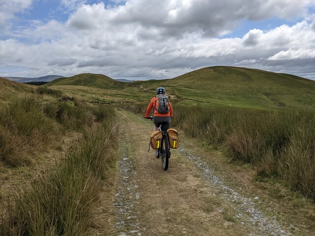
Bryn Moel is known for its distinctive shape and rugged terrain. Its slopes are covered in a mixture of grass, heather, and rocky outcrops, providing a habitat for various plant and animal species. The hill is popular among hikers and nature enthusiasts, who are drawn to its natural beauty and challenging trails.

From the summit of Bryn Moel, visitors can enjoy panoramic views of Montgomeryshire and the surrounding areas. On a clear day, one can see the rolling hills, green valleys, and distant mountains that make up the picturesque Welsh countryside. The hill is also a great vantage point for observing wildlife, such as birds of prey and grazing sheep.

Access to Bryn Moel is relatively straightforward, with several footpaths and trails leading to the summit. These paths can be steep and uneven in some areas, requiring a moderate level of fitness and proper hiking gear. As with any outdoor activity, it is important for visitors to be prepared and take necessary safety precautions.

Overall, Bryn Moel offers a rewarding and scenic experience for those seeking to explore the natural beauty of Montgomeryshire.

If you have any feedback on the listing, please let us know in the comments section below.

Bryn Moel Images

Images are sourced within 2km of 52.50473/-3.809212 or Grid Reference SN7791. Thanks to Geograph Open Source API. All images are credited.

The track is impassable due to water and mud  Probably due to 4x4 activity. An alternative path has been created on the bank on the right.
The track is impassable due to water and mud
Probably due to 4x4 activity. An alternative path has been created on the bank on the right.
This is a track? It is more like an obstacle course, due to erosion - quite possibly from 4x4s.
This is a track?
It is more like an obstacle course, due to erosion - quite possibly from 4x4s.
Approaching the plantation The path on the ground, such as it is, does not follow the line shown on the map. The small plantation is in an isolated place - I wonder why it is there?
Approaching the plantation
The path on the ground, such as it is, does not follow the line shown on the map. The small plantation is in an isolated place - I wonder why it is there?
The 'path' across the moor There is the vestige of a path on this line, but no trace of a path on the line shown on the map. This area is not often frequented!
The 'path' across the moor
There is the vestige of a path on this line, but no trace of a path on the line shown on the map. This area is not often frequented!
Looking down into the moorland valley
The moorland slopes of Foel Grafiau
The moorland track stretches out ahead The OS Map labels this track, close to here, as being 'Lon Las Cymru', but Lon Las Cymru doesn't pass this way and there are no other such labels on other parts of this track. Very strange!
The moorland track stretches out ahead
The OS Map labels this track, close to here, as being 'Lon Las Cymru', but Lon Las Cymru doesn't pass this way and there are no other such labels on other parts of this track. Very strange!
The track along the east side of Foel Uchaf
Looking east near Foel Uchaf
The Hyddgen Valley viewed from Plynlimon With Cadair Idris on the horizon.
The Hyddgen Valley viewed from Plynlimon
With Cadair Idris on the horizon.
Banc Llechwedd-mawr and the Hyddgen Valley Viewed from Plynlimon.
Banc Llechwedd-mawr and the Hyddgen Valley
Viewed from Plynlimon.
Carn Gwilym from the south west The pair of relatively modern cairns were built from the remains of the original ancient cairn. They are instantly recognisable from points afar, and are useful navigation aids in this remote and fairly featureless country.
Carn Gwilym from the south west
The pair of relatively modern cairns were built from the remains of the original ancient cairn. They are instantly recognisable from points afar, and are useful navigation aids in this remote and fairly featureless country.
Sunlight on Carn Hyddgen On a cold mixed autumnal day, a sunlit patch appears on the hill.
Sunlight on Carn Hyddgen
On a cold mixed autumnal day, a sunlit patch appears on the hill.
The summit of Carn Hyddgen Dominated by the twin cairns known as Cairn Gwilym. Rebuilt from ancient burial cairns, they are visible from miles around and thus aid navigation, which is probably their purpose. An old route from the upper Wye valley to Machynlleth crosses Pumlumon and passes to the west.

Cadair Idris stands out in the distance.
The summit of Carn Hyddgen
Dominated by the twin cairns known as Cairn Gwilym. Rebuilt from ancient burial cairns, they are visible from miles around and thus aid navigation, which is probably their purpose. An old route from the upper Wye valley to Machynlleth crosses Pumlumon and passes to the west. Cadair Idris stands out in the distance.
Hyddgen [Farm] At shearing time.
Hyddgen [Farm]
At shearing time.
Gate on the road south through Cwm Hyddgen
Ford across Llygnant Llygnant has a confluence with Nant Goch just by Hyddgen farm at <a href="https://www.geograph.org.uk/gridref/SN7804891085">SN7804891085</a> to form Afon Hyddgen which itself runs south for just a couple of kilometres before joining Afon Hengwm.
Ford across Llygnant
Llygnant has a confluence with Nant Goch just by Hyddgen farm at SN7804891085 to form Afon Hyddgen which itself runs south for just a couple of kilometres before joining Afon Hengwm.
Rough ground on Mynydd Bychan Supposedly following a right of way through the forestry but the path disappeared and I had to fight my way through the undergrowth. Wish I had my machete with me!
Rough ground on Mynydd Bychan
Supposedly following a right of way through the forestry but the path disappeared and I had to fight my way through the undergrowth. Wish I had my machete with me!
Show me another place!

Bryn Moel is located at Grid Ref: SN7791 (Lat: 52.50473, Lng: -3.809212)

Unitary Authority: Powys

Police Authority: Dyfed Powys

What 3 Words

///juggled.formed.blankets. Near Machynlleth, Powys

Nearby Locations

Bryn Moel

Related Wikis

Battle of Mynydd Hyddgen

The Battle of Mynydd Hyddgen took place between the Welsh and English in June 1401. It was part of the Welsh Revolt of 1400-1415 led by Owain Glyndŵr against...

Clipyn Du

Clipyn Du is a mountain in northern Powys in Wales. Also known as Tarren Bwlch-Gwyn or Siambwr Trawsfynydd, it is one of the higher summits of the area...

Siambr Trawsfynydd

Siambr Trawsfynydd is a mountain in Ceredigion, Wales, located to the north of Pumlumon. It is 582 m (1,910 ft) above sea level and one of the higher summits...

Pistyll y Llyn

Pistyll y Llyn is one of the tallest waterfalls in Wales and the United Kingdom. It is a horsetail style set of falls which are located in the Cambrian...

Nearby Amenities

Located within 500m of 52.50473,-3.809212
Bryn Moel
Created By: POI Editor
Ele: 490
Natural: peak
Source: npe
Lat/Long: 52.5047427/-3.8093434
The data included in this document is from www.openstreetmap.org. The data is made available under ODbL.

Have you been to Bryn Moel?

Leave your review of Bryn Moel below (or comments, questions and feedback).