Bryn-pig

Hill, Mountain in Merionethshire

Wales

Bryn-pig

South-western slopes of Moel y Feidiog Following the fence SW from the summit.
Bryn-pig is the hill ahead.
The public footpath that crosses the fence just south of here has no trace on the ground, but there is a stile.
South-western slopes of Moel y Feidiog Credit: Vivien and Geoff Crowder

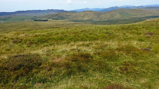
Bryn-pig is a prominent hill located in the county of Merionethshire in Wales, United Kingdom. Standing at an impressive height of approximately 300 meters (984 feet), it is considered a significant landmark in the area. The hill is situated near the small village of Bryn-pig, which takes its name from this natural feature.

The hill offers breathtaking panoramic views of the surrounding countryside, making it a popular destination for both locals and tourists alike. Its strategic location allows visitors to enjoy stunning vistas of the rolling green hills, picturesque valleys, and the nearby coastline.

Bryn-pig is covered in lush vegetation, featuring a diverse range of flora and fauna. The hill is home to various species of birds, including red kites, buzzards, and peregrine falcons, making it a haven for birdwatchers and nature enthusiasts. The area surrounding the hill is also known for its wildflowers, providing a burst of color during the spring and summer months.

For outdoor enthusiasts, Bryn-pig offers several walking trails and footpaths, allowing visitors to explore the hill and its surroundings at their own pace. These trails cater to different fitness levels, making it accessible for people of all ages and abilities.

Overall, Bryn-pig in Merionethshire is a natural landmark that offers stunning views, diverse wildlife, and opportunities for outdoor activities. Whether it's a leisurely stroll or a challenging hike, this hill provides a memorable experience for all who venture to its summit.

If you have any feedback on the listing, please let us know in the comments section below.

Bryn-pig Images

Images are sourced within 2km of 52.859073/-3.8328922 or Grid Reference SH7630. Thanks to Geograph Open Source API. All images are credited.

South-western slopes of Moel y Feidiog Following the fence SW from the summit.
Bryn-pig is the hill ahead.
The public footpath that crosses the fence just south of here has no trace on the ground, but there is a stile.
South-western slopes of Moel y Feidiog
Following the fence SW from the summit. Bryn-pig is the hill ahead. The public footpath that crosses the fence just south of here has no trace on the ground, but there is a stile.
View from Bryn-pig summit Bryn-pig is a 500m hill that is reached only by tortuous walking through rough tussocky grass and reeds, an unremarkable top with views no better than other high ground hereabouts.
View from Bryn-pig summit
Bryn-pig is a 500m hill that is reached only by tortuous walking through rough tussocky grass and reeds, an unremarkable top with views no better than other high ground hereabouts.
Patches on the military road At the junction with a less well maintained track. All relics of military training.
Patches on the military road
At the junction with a less well maintained track. All relics of military training.
A junction of military roads
A stream near Defeidiog-uchaf Unnamed on the map, but one of the sources of the Nant Ganol. 'Uchaf' means 'upper'. There is the nearby ruin of Defeidiog-ganol, with 'ganol' meaning 'middle'. There does not appear to be a Defeidiog-isaf (lower), but presumably there was at one time.  Defeidiog possibly is derived from 'Defaid', meaning sheep, so maybe the meaning is 'Upper sheep place' and 'Middle sheep place'.
A stream near Defeidiog-uchaf
Unnamed on the map, but one of the sources of the Nant Ganol. 'Uchaf' means 'upper'. There is the nearby ruin of Defeidiog-ganol, with 'ganol' meaning 'middle'. There does not appear to be a Defeidiog-isaf (lower), but presumably there was at one time. Defeidiog possibly is derived from 'Defaid', meaning sheep, so maybe the meaning is 'Upper sheep place' and 'Middle sheep place'.
Moorland near Defeidiog-uchaf
A lonely tree at Defeidiog-uchaf
The stream below Defeidiog-uchaf It's not obvious in the photo, but the pool had been constructed as a sheep dip.
The stream below Defeidiog-uchaf
It's not obvious in the photo, but the pool had been constructed as a sheep dip.
All that remains of Defeidiog-uchaf
The remains of Defeidiog-uchaf
Quite a fine specimen The Defeidiog-uchaf tree must have been protected from sheep by the ruins and is now a fine, but lonely, mature tree in the moorland.
Quite a fine specimen
The Defeidiog-uchaf tree must have been protected from sheep by the ruins and is now a fine, but lonely, mature tree in the moorland.
Forest clearing has restored the view Looking over the Afon Bryn-llin-fawr.
Forest clearing has restored the view
Looking over the Afon Bryn-llin-fawr.
Recently cleared land above the Afon Bryn-llin-fawr Many of the felled trees seem to have been abandoned where they fell. Left for collection later, probably.
Recently cleared land above the Afon Bryn-llin-fawr
Many of the felled trees seem to have been abandoned where they fell. Left for collection later, probably.
The grassy and boggy track near Defeidiog-uchaf It probably dates from the military training era and is more suitable for tanks than for bicycles!
The grassy and boggy track near Defeidiog-uchaf
It probably dates from the military training era and is more suitable for tanks than for bicycles!
The cleared area above Afon Bryn-llin-fawr The piles of logs that were here in 2021 have been taken away. See: <a title="https://www.geograph.org.uk/photo/7407938" href="https://www.geograph.org.uk/photo/7407938">Link</a>
The cleared area above Afon Bryn-llin-fawr
The piles of logs that were here in 2021 have been taken away. See: Link
Ordnance Survey Cut Mark This OS cut mark can be found on the barn south of the road. It marks a point 318.806m above mean sea level.
Ordnance Survey Cut Mark
This OS cut mark can be found on the barn south of the road. It marks a point 318.806m above mean sea level.
Ordnance Survey Pivot This OS pivot can be found on a stone SW side of the road. It marks a point 330.672m above mean sea level.
Ordnance Survey Pivot
This OS pivot can be found on a stone SW side of the road. It marks a point 330.672m above mean sea level.
Ordnance Survey Cut Mark This OS cut mark can be found on a stone north side of the road. It marks a point 344.878m above mean sea level.
Ordnance Survey Cut Mark
This OS cut mark can be found on a stone north side of the road. It marks a point 344.878m above mean sea level.
Show me another place!

Bryn-pig is located at Grid Ref: SH7630 (Lat: 52.859073, Lng: -3.8328922)

Unitary Authority: Gwynedd

Police Authority: North Wales

What 3 Words

///cupboards.tipping.spicy. Near Bronaber, Gwynedd

Nearby Locations

Bryn-pig

Related Wikis

Abergeirw

Abergeirw is a hamlet located in Gwynedd, North Wales. The village of nine properties is located between Dolgellau and Trawsfynydd. On 19 December 2008...

Merionethshire

Merionethshire or Merioneth (Welsh: Meirionnydd or Sir Feirionnydd) is one of thirteen historic counties of Wales, a vice county and a former administrative...

Gwynfynydd Gold Mine

Gwynfynydd Gold Mine is near Ganllwyd, Dolgellau, Gwynedd, Wales. The lode, which was discovered in 1860, was worked from 1884. It has produced more than...

Moel Oernant

Moel Oernant is a 503-metre (1,650 ft) high hill in the community of Trawsfynydd in the county of Gwynedd in North Wales. It has a number of western tops...

Pistyll Cain

Pistyll Cain, also written as Pistill Cain and Pistill Y Caen, is a renowned waterfall in Meirionnydd (Sir Feirionnydd) in north Wales. It lies north-east...

Snowdonia

Snowdonia, or Eryri (pronounced [ɛrəri] ), is a mountainous region and national park in northwestern Wales. It contains all 15 mountains in Wales over...

Harlech Dome

The Harlech Dome is a geological dome in southern Snowdonia in north Wales. It extends approximately from Blaenau Ffestiniog in the north to Tywyn in the...

Afon Mawddach

The Afon Mawddach (English: River Mawddach) is a river in Gwynedd, Wales, which has its source in a wide area SH820300 north of Dduallt in Snowdonia. It...

Nearby Amenities

Located within 500m of 52.859073,-3.8328922
Bryn-pig
Ele: 523
Natural: peak
Wikidata: Q20585143
Wikipedia: cy:Bryn-pig
Lat/Long: 52.85908/-3.8328947
The data included in this document is from www.openstreetmap.org. The data is made available under ODbL.

Have you been to Bryn-pig?

Leave your review of Bryn-pig below (or comments, questions and feedback).