Beinn a' Bhuchanaich

Hill, Mountain in Nairnshire

Scotland

Beinn a' Bhuchanaich

Braeval Farm
Braeval Farm Credit: JThomas

Beinn a' Bhuchanaich is a prominent hill located in the county of Nairnshire, Scotland. With a summit elevation of 862 meters (2,828 feet), it falls under the category of a Corbett, which refers to a Scottish hill between 2,500 and 3,000 feet in height.

Situated in the Monadhliath Mountains, Beinn a' Bhuchanaich offers stunning panoramic views of the surrounding landscape. It is located about 10 kilometers southeast of the town of Newtonmore and is easily accessible for hikers and mountaineers.

The ascent of Beinn a' Bhuchanaich is relatively straightforward, with several well-defined paths leading to the summit. The starting point for most walkers is usually the small village of Laggan, located to the west of the hill. From here, a path meanders through heather-clad slopes, gradually gaining elevation until reaching the ridge. The final approach to the summit involves some steeper sections, but nothing too challenging for experienced walkers.

Once at the top, visitors are rewarded with breathtaking views of the Cairngorms National Park, the Grampian Mountains, and the surrounding glens. On clear days, it is even possible to catch a glimpse of Ben Nevis, the highest mountain in the British Isles. The hill is also home to a variety of wildlife, including red deer, mountain hare, and golden eagles, adding to the natural beauty of the area.

Overall, Beinn a' Bhuchanaich offers outdoor enthusiasts a rewarding and accessible hiking experience, with its stunning vistas and diverse wildlife making it a must-visit destination in Nairnshire.

If you have any feedback on the listing, please let us know in the comments section below.

Beinn a' Bhuchanaich Images

Images are sourced within 2km of 57.435136/-4.0667837 or Grid Reference NH7640. Thanks to Geograph Open Source API. All images are credited.

Braeval Farm
Braeval Farm
Braeval Farm
Braeval Farm
Looking up the fence line Looking up the fence line on the inaugural Monadhliath Challenge, September 2007. It's a bit boggy but runnable and sort of ok on a bike.
Looking up the fence line
Looking up the fence line on the inaugural Monadhliath Challenge, September 2007. It's a bit boggy but runnable and sort of ok on a bike.
Railway Subway near Braeval Farm Track and burn goes under railway here.
Railway Subway near Braeval Farm
Track and burn goes under railway here.
Footbridge with  Burn under it in Railway Subway I saw this while looking for farm road subway near Braeval.  I always thought these were tunnels
Footbridge with Burn under it in Railway Subway
I saw this while looking for farm road subway near Braeval. I always thought these were tunnels
Burn Coming Off Grouse Moor on Beinn a' Bhuchanaich There was a lot of water in burn and on moor although you had to be beside it to see it.
Burn Coming Off Grouse Moor on Beinn a' Bhuchanaich
There was a lot of water in burn and on moor although you had to be beside it to see it.
Craggie Burn Tributary going down Towards Braeval Craggie Burn Tributary from Clava Forest deer fencing looking towards Auchnahillin
Craggie Burn Tributary going down Towards Braeval
Craggie Burn Tributary from Clava Forest deer fencing looking towards Auchnahillin
Ford Across Craggie Burn Tributary The gate at other side of ford was locked. The track at the side went under railway near Braeval Steadings.  Only gate I've had to climb in whole area, it was also the only place I was challenged for being there. I was told it was private although there was no notices.
Ford Across Craggie Burn Tributary
The gate at other side of ford was locked. The track at the side went under railway near Braeval Steadings. Only gate I've had to climb in whole area, it was also the only place I was challenged for being there. I was told it was private although there was no notices.
Railway Subway near Braeval Farm
Old Shooting Butt on Grouse Moor near Clava Forest Beinn Bhreac can be seen in background.  Photo was taken from Clave Forest deer fencing.
Old Shooting Butt on Grouse Moor near Clava Forest
Beinn Bhreac can be seen in background. Photo was taken from Clave Forest deer fencing.
Looking Up Fence Line in Autumn The colours were fantastic when the sun was shining.  Not only was it the trees in their Autumn colours but the mosses and glasses where the heather had been burnt were also fantastic
Looking Up Fence Line in Autumn
The colours were fantastic when the sun was shining. Not only was it the trees in their Autumn colours but the mosses and glasses where the heather had been burnt were also fantastic
Looking SW Across Grouse Moor beside Clava Forest Strathnairn can be seen below from SW of Beinn a' Bhuchanaich summit
Looking SW Across Grouse Moor beside Clava Forest
Strathnairn can be seen below from SW of Beinn a' Bhuchanaich summit
Extension to Finglack Track on  Beinn a' Bhuchanaich Track is leading up to Beinn Bhuidhe Mhor
Extension to Finglack Track on Beinn a' Bhuchanaich
Track is leading up to Beinn Bhuidhe Mhor
Boundary Cairn and Marker on Grouse Moor PM is cut into on marker, as fence goes on to Beinn a' Bhuchanaich summit
Boundary Cairn and Marker on Grouse Moor
PM is cut into on marker, as fence goes on to Beinn a' Bhuchanaich summit
Very Boggy Path on Grouse Moor This path crosses moor from Clava Forest to footbridge across the Dalriach Burn
Very Boggy Path on Grouse Moor
This path crosses moor from Clava Forest to footbridge across the Dalriach Burn
Old Fence Crossing Grouse Moor Photo taken from NH761396 looking SSW the whole moor is very flat here and quite featureless
Old Fence Crossing Grouse Moor
Photo taken from NH761396 looking SSW the whole moor is very flat here and quite featureless
Post on Moor near Dalriach Burn These posts were all over the moor.  They were all next to a peat ditch and had a white granular substance beside them.  Does anyone know what they are for?
Post on Moor near Dalriach Burn
These posts were all over the moor. They were all next to a peat ditch and had a white granular substance beside them. Does anyone know what they are for?
Looking west across Beinn Bhreac to Carn Dubh Mor The moor was featureless except for these posts, water course of Dalriach Burn and track. I had to pace, take compass reading and mark hills to be sure of where I was.
Looking west across Beinn Bhreac to Carn Dubh Mor
The moor was featureless except for these posts, water course of Dalriach Burn and track. I had to pace, take compass reading and mark hills to be sure of where I was.
Show me another place!

Beinn a' Bhuchanaich is located at Grid Ref: NH7640 (Lat: 57.435136, Lng: -4.0667837)

Unitary Authority: Highland

Police Authority: Highlands and Islands

What 3 Words

///films.gilding.clips. Near Westhill, Highland

Nearby Locations

Beinn a' Bhuchanaich

Related Wikis

Daviot railway station

Daviot railway station served the village of Daviot, Highland, Scotland, from 1897 to 1965 on the Inverness and Aviemore Direct Railway. == History... ==

Daviot Castle

Daviot Castle was a 15th-century castle, about 6 miles (10 kilometres) southeast of Inverness, Highland, Scotland, and west of the River Nairn at Daviot...

Daviot, Highland

Daviot (Gaelic: Deimhidh) is a village in the Highland council area of Scotland. It is about 8 kilometres (5 mi) south east of the city of Inverness, next...

Clava cairn

The Clava cairn is a type of Bronze Age circular chamber tomb cairn, named after the group of three cairns at Balnuaran of Clava, to the east of Inverness...
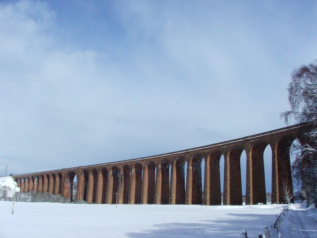
Culloden Viaduct

The Culloden Viaduct is a railway viaduct on the Highland Main Line, to the east of the city of Inverness, in the Highland council area of Scotland. It...

Battle of Culloden

The Battle of Culloden (; Scottish Gaelic: Blàr Chùil Lodair) was the final confrontation of the Jacobite rising of 1745. On 16 April 1746, the Jacobite...

Moy Hall

Moy Hall near the village of Moy, south of Inverness, is the home of the chiefs of the Clan Mackintosh, a Highland Scottish clan. == History == The original...

Culloden Moor railway station

Culloden Moor railway station served the village of Culloden, Highland, Scotland from 1898 to 1965 on the Inverness and Aviemore Direct Railway. ��2�...

Nearby Amenities

Located within 500m of 57.435136,-4.0667837
Beinn a' Bhuchanaich
Ele: 399
Natural: peak
Source: OD Streetview
Lat/Long: 57.4345525/-4.0639159
The data included in this document is from www.openstreetmap.org. The data is made available under ODbL.

Have you been to Beinn a' Bhuchanaich?

Leave your review of Beinn a' Bhuchanaich below (or comments, questions and feedback).