Ben Clach

Hill, Mountain in Perthshire

Scotland

Ben Clach

Ben Clach View from the south with Meall a' Choire Riabhaich in the middle distance.
Ben Clach Credit: Richard Webb

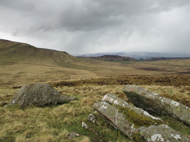
Ben Clach is a prominent hill located in Perthshire, Scotland. Standing at an elevation of approximately 776 meters (2,546 feet), it offers breathtaking panoramic views of the surrounding countryside. Situated within the Grampian Mountains, Ben Clach is a popular destination for hikers, nature enthusiasts, and outdoor adventurers.

The hill is characterized by its distinct rocky terrain, which gives it its name, as "Ben Clach" translates to "rocky mountain" in Gaelic. The slopes of Ben Clach are covered in heather and grasses, providing a habitat for various plant and animal species. The hill is particularly known for its diverse birdlife, including the golden eagle, peregrine falcon, and red grouse.

The ascent to the summit of Ben Clach can be challenging, but the rewards are worth it. On a clear day, visitors are treated to stunning views of the surrounding mountains, rolling hills, and shimmering lochs. It is recommended to bring appropriate hiking gear and be prepared for changing weather conditions.

The hill is easily accessible from nearby towns such as Pitlochry and Aberfeldy, with several marked hiking trails leading to its summit. These trails vary in difficulty, catering to both experienced hikers and beginners. The most popular route starts at the Rannoch Station, taking hikers across moorland before ascending the steep slopes of Ben Clach.

Overall, Ben Clach in Perthshire offers an incredible outdoor experience, allowing visitors to immerse themselves in the natural beauty of the Scottish Highlands.

If you have any feedback on the listing, please let us know in the comments section below.

Ben Clach Images

Images are sourced within 2km of 56.313351/-4.0074712 or Grid Reference NN7515. Thanks to Geograph Open Source API. All images are credited.

Ben Clach View from the south with Meall a' Choire Riabhaich in the middle distance.
Ben Clach
View from the south with Meall a' Choire Riabhaich in the middle distance.
Ben Clach, summit Ben Clach has a rough plateau like summit, covered in deep heather.
Ben Clach, summit
Ben Clach has a rough plateau like summit, covered in deep heather.
Ben Clach hillside The approach to Ben Clach from the east is across wet ground leading to rough lower slopes.  The top of the hill is hard going too for walkers, but in between there is some pleasant walking amongst these boulders.  A faint path works its way uphill.
Ben Clach hillside
The approach to Ben Clach from the east is across wet ground leading to rough lower slopes. The top of the hill is hard going too for walkers, but in between there is some pleasant walking amongst these boulders. A faint path works its way uphill.
Wet path The path crossing the valley of the Allt an-t Seillich has a reputation for being wet.  This is a particularly bad section - it's not all like this.
Wet path
The path crossing the valley of the Allt an-t Seillich has a reputation for being wet. This is a particularly bad section - it's not all like this.
The Carse Wetland under Ben Clach.
The Carse
Wetland under Ben Clach.
Ben Clach (summit) Looking towards Ben Vorlich and Stuc a' Chroin from the summit of Ben Clach.
Ben Clach (summit)
Looking towards Ben Vorlich and Stuc a' Chroin from the summit of Ben Clach.
Old Milestone by the B827, south of Tigh na Blair, Muthill parish Stone post by the B827, in parish of Muthill ( District), South of Tigh na Blair, on roadside verge, East side of road.

Inscription reads:-
: ARDOCH / 6 : : COMRIE / 5 :

Surveyed

Milestone Society National ID: PK_CMAR05
Old Milestone by the B827, south of Tigh na Blair, Muthill parish
Stone post by the B827, in parish of Muthill ( District), South of Tigh na Blair, on roadside verge, East side of road. Inscription reads:- : ARDOCH / 6 : : COMRIE / 5 : Surveyed Milestone Society National ID: PK_CMAR05
Corriebeagh Burn
Corriebeagh Burn
Track beside Corriebeagh Burn The well marked track leads into Findhu Glen and on to Glen Artney.
Track beside Corriebeagh Burn
The well marked track leads into Findhu Glen and on to Glen Artney.
Corriebeagh Burn
Corriebeagh Burn
Track leading through Findhu Glen to Glen Artney
The Carse, a wet grassy hollow
Ben Clach
Ben Clach
Bog pool on moorland below Ben Clach The house and buildings at Tigh-na-Blair are visible in the middle distance, with wintry showers passing over the distant hills on an unseasonably cold day for the start of May.
Bog pool on moorland below Ben Clach
The house and buildings at Tigh-na-Blair are visible in the middle distance, with wintry showers passing over the distant hills on an unseasonably cold day for the start of May.
Corriebeagh Burn Pictured on a chilly day at the start of May. Cuckoos were calling from the trees on the right-hand bank.
Corriebeagh Burn
Pictured on a chilly day at the start of May. Cuckoos were calling from the trees on the right-hand bank.
Northern slopes of Meall a' Choire Riabhaich Meall a' Choire Riabhaich is the rounded hill of the brindled (grey/brown) corrie, and the colours are certainly muted in this photograph, with a bright start having given way to wintry showers to the north.
Northern slopes of Meall a' Choire Riabhaich
Meall a' Choire Riabhaich is the rounded hill of the brindled (grey/brown) corrie, and the colours are certainly muted in this photograph, with a bright start having given way to wintry showers to the north.
Rocks on Meall a' Choire Riabhaich Meall a' Choire Riabhaich is the rounded hill of the brindled (grey/brown) corrie, and the colours are certainly muted in this photograph, with a bright start having given way to wintry showers to the north.
Rocks on Meall a' Choire Riabhaich
Meall a' Choire Riabhaich is the rounded hill of the brindled (grey/brown) corrie, and the colours are certainly muted in this photograph, with a bright start having given way to wintry showers to the north.
Allt an t-Seilich Slow running burn draining bogs beneath Ben Clach. View down the glen to the Ochils.
Allt an t-Seilich
Slow running burn draining bogs beneath Ben Clach. View down the glen to the Ochils.
Show me another place!

Ben Clach is located at Grid Ref: NN7515 (Lat: 56.313351, Lng: -4.0074712)

Unitary Authority: Perth and Kinross

Police Authority: Tayside

What 3 Words

///unwound.vanished.probing. Near Comrie, Perth & Kinross

Nearby Locations

Ben Clach

Related Wikis

Beinn nan Eun (Perth and Kinross)

Beinn nan Eun is a hill in the Glen Artney Hills range immediately south of the Highland Boundary Fault, part of the Central Lowlands of Scotland. The...

Glen Artney

Glen Artney or Glenartney is a valley in Perthshire, Scotland.Several ships have been named Glenartney: SS Glenartney (1869), an iron-hulled steamship...

Cultybraggan Camp

Cultybraggan Camp lies close to the village of Comrie, in west Perthshire, Scotland. It was first used as a prisoner of war (PoW) camp during World War...

Braes of Doune Wind Farm

Braes of Doune Wind Farm is a wind farm located close to Stirling, Scotland and opened in 2007. == History == The farm was built by Alfred McAlpine in...

Nearby Amenities

Located within 500m of 56.313351,-4.0074712
Ben Clach
Corbett: no
Description: Hill of the stone (from Beinn Clach)
Ele: 533
Graham: no
Marilyn: yes
Munro: no
Natural: peak
Prominence: 230
Lat/Long: 56.3134446/-4.0068382
The data included in this document is from www.openstreetmap.org. The data is made available under ODbL.

Have you been to Ben Clach?

Leave your review of Ben Clach below (or comments, questions and feedback).