Bentudor

Hill, Mountain in Kirkcudbrightshire

Scotland

Bentudor

Bengairn A rough hill seen from the Torr peninsula.
Bengairn Credit: Richard Webb

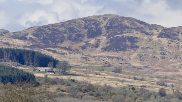
Bentudor is a hill located in Kirkcudbrightshire, Scotland. It is part of the Southern Uplands range and stands at an elevation of 252 meters (827 feet) above sea level. The hill is known for its rugged and rocky terrain, making it a popular destination for hikers and outdoor enthusiasts looking for a challenging climb.

Bentudor offers stunning panoramic views of the surrounding countryside, including rolling hills, lush green valleys, and the nearby Solway Firth. On a clear day, visitors can even catch a glimpse of the Isle of Man in the distance.

The hill is home to a variety of plant and animal species, including heather, bracken, and various birds of prey. Due to its remote location and rugged landscape, Bentudor provides a peaceful and tranquil escape from the hustle and bustle of everyday life.

Overall, Bentudor is a beautiful and scenic hill that offers a unique opportunity to explore the natural beauty of Kirkcudbrightshire and enjoy a challenging outdoor adventure.

If you have any feedback on the listing, please let us know in the comments section below.

Bentudor Images

Images are sourced within 2km of 54.867132/-3.9358178 or Grid Reference NX7554. Thanks to Geograph Open Source API. All images are credited.

Bengairn A rough hill seen from the Torr peninsula.
Bengairn
A rough hill seen from the Torr peninsula.
B727, Shielahill The road passing deciduous woodland which is growing on a wetland. Lots of willows.
B727, Shielahill
The road passing deciduous woodland which is growing on a wetland. Lots of willows.
Pasture below Corra Hill Wet grazing on higher ground between Kirkcudbright and Castle Douglas.
Pasture below Corra Hill
Wet grazing on higher ground between Kirkcudbright and Castle Douglas.
Sunset over Bengairn & Screel
Corra Hill Above the B727.
Corra Hill
Above the B727.
Summit of Bengairn
Summit of Bengairn
Castlehill Farm buildings
Track to Loch Dougan
Looking northeast B 727
Looking northeast
B 727
Road junction at Sheillahill, Kirkcudbright Sheillahill is behind the photographer  with the road ahead leading to Nether Linkins.
Road junction at Sheillahill, Kirkcudbright
Sheillahill is behind the photographer with the road ahead leading to Nether Linkins.
Blackbreast Hill. Looking across to Barcloy Hill from Blackbreast Hill.
Blackbreast Hill.
Looking across to Barcloy Hill from Blackbreast Hill.
Glenhead, Auchencairn View northwest along track to Glenhead Farm. In the distance is Hass Farm nestling under Dungarry and Bentudor hills.
Glenhead, Auchencairn
View northwest along track to Glenhead Farm. In the distance is Hass Farm nestling under Dungarry and Bentudor hills.
Rough Track Rough Track.
Rough Track
Rough Track.
Ben Tudor, Bengairn, Midhill, and Screel (left to right) The range of hills as seen from above Gibbs Hole Wood on Almorness peninsula.  At the left hand end of the range is the impressive Dungarry hill fort (NX 757 535)
Ben Tudor, Bengairn, Midhill, and Screel (left to right)
The range of hills as seen from above Gibbs Hole Wood on Almorness peninsula. At the left hand end of the range is the impressive Dungarry hill fort (NX 757 535)
Bengairn View from the summit of Screel Hill.
Bengairn
View from the summit of Screel Hill.
Cairn in centre of Dungarry Fort The fort is on the hilltop and consists of a roughly circular drystane wall, somewhat derelict.
Cairn in centre of Dungarry Fort
The fort is on the hilltop and consists of a roughly circular drystane wall, somewhat derelict.
Pasture above Hass, looking out to the Solway
Pond by Nether Linkins Sheepfolds Looking Southeast with Bentudor on the left and Dungarry just visible left of centre, and Knoits of Bentudor on the right.
Pond by Nether Linkins Sheepfolds
Looking Southeast with Bentudor on the left and Dungarry just visible left of centre, and Knoits of Bentudor on the right.
Show me another place!

Bentudor is located at Grid Ref: NX7554 (Lat: 54.867132, Lng: -3.9358178)

Unitary Authority: Dumfries and Galloway

Police Authority: Dumfries and Galloway

What 3 Words

///pretty.implanted.escalated. Near Kirkcudbright, Dumfries & Galloway

Nearby Locations

Bentudor

Related Wikis

Airieland

Airieland is a farm in the historical county of Kirkcudbrightshire, in the Scottish council area of Dumfries and Galloway. It is found 3 miles (5 km) south...

Gelston Castle

Gelston Castle, located near Castle Douglas in Kirkcudbrightshire in Dumfries and Galloway, Scotland, was built by Sir William Douglas of Castle Douglas...

Auchencairn

Auchencairn ([ɔxən'kʰɛ:(r)n]) is a village in the historical county of Kirkcudbrightshire in the Dumfries and Galloway region of Scotland. It is located...

Orchardton Castle

Orchardton Castle overlooks the Solway Coast. Built in the 1880s, this is a Grade B listed property formerly known as Orchardton House. Built around a...

Nearby Amenities

Located within 500m of 54.867132,-3.9358178
Bentudor
Ele: 274
Natural: peak
Lat/Long: 54.8670809/-3.9359024
The data included in this document is from www.openstreetmap.org. The data is made available under ODbL.

Have you been to Bentudor?

Leave your review of Bentudor below (or comments, questions and feedback).