Birns

Hill, Mountain in Stirlingshire

Scotland

Birns

Old fingerpost A clearer view of the unique fingerpost at the crossroads on the B818 near Carron Bridge.  It was cast at the Smith and Wellstead Foundry in Bonnybridge and is the only known survivor in Scotland of this style of fingerpost with a 6" diameter ball finial and arrowhead ends to the fingers.
Old fingerpost Credit: John Riddell

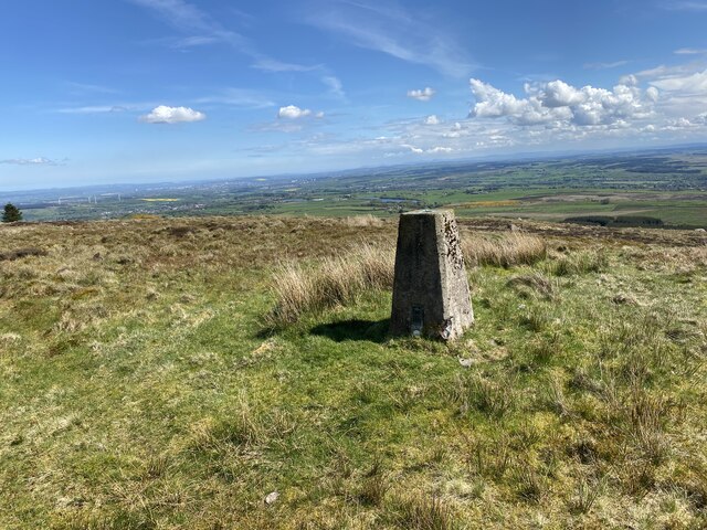
Birns is a prominent hill located in Stirlingshire, Scotland. Standing at an elevation of approximately 385 meters (1263 feet), it offers breathtaking panoramic views of the surrounding countryside. The hill is situated near the village of Balfron, just a few miles northwest of the city of Stirling.

Birns is a popular destination for outdoor enthusiasts and nature lovers due to its diverse range of flora and fauna. The hill is covered in heather, grasses, and scattered woodland, creating a picturesque landscape. Its slopes are home to various species of birds, including buzzards, kestrels, and pheasants, making it a haven for birdwatchers.

Hiking is a popular activity on Birns, with several paths and trails leading to the summit. The ascent can be moderately challenging, but the reward is worth the effort, as hikers are treated to stunning views of Loch Lomond and the Trossachs National Park to the west, and the Ochil Hills to the east.

The hill also holds historical significance, as it is believed to have been used as a lookout point during ancient times. Additionally, remnants of old settlements and structures can be found scattered around its base, adding to its cultural value.

Overall, Birns in Stirlingshire is a captivating hill that offers a tranquil escape into nature, providing visitors with awe-inspiring views, diverse wildlife, and a chance to explore the region's rich history.

If you have any feedback on the listing, please let us know in the comments section below.

Birns Images

Images are sourced within 2km of 56.017144/-3.9970457 or Grid Reference NS7582. Thanks to Geograph Open Source API. All images are credited.

Old fingerpost A clearer view of the unique fingerpost at the crossroads on the B818 near Carron Bridge.  It was cast at the Smith and Wellstead Foundry in Bonnybridge and is the only known survivor in Scotland of this style of fingerpost with a 6" diameter ball finial and arrowhead ends to the fingers.
Old fingerpost
A clearer view of the unique fingerpost at the crossroads on the B818 near Carron Bridge. It was cast at the Smith and Wellstead Foundry in Bonnybridge and is the only known survivor in Scotland of this style of fingerpost with a 6" diameter ball finial and arrowhead ends to the fingers.
Forestry track restricted to foot, hoof and cycle usage Looking south-westward.
Forestry track restricted to foot, hoof and cycle usage
Looking south-westward.
A somewhat overgrown and disused forestry track Looking eastward.
A somewhat overgrown and disused forestry track
Looking eastward.
Cleared, replanted forest on Denny Muir The dense forest seen ten years ago in <a href="https://www.geograph.org.uk/photo/3485770">NS7582 : Forest, Denny Muir</a> has been felled and replanted. For now one has a clear view across the Denny Muir to Birns Hill and beyond.
Cleared, replanted forest on Denny Muir
The dense forest seen ten years ago in NS7582 : Forest, Denny Muir has been felled and replanted. For now one has a clear view across the Denny Muir to Birns Hill and beyond.
Birns hill A rocky knoll above the boggy moorland of Denny Muir. The dry stane dyke runs across the hill from the west.
Birns hill
A rocky knoll above the boggy moorland of Denny Muir. The dry stane dyke runs across the hill from the west.
Birns trig point The pillar is seen looking roughly west, with Tomtain at upper left.
Birns trig point
The pillar is seen looking roughly west, with Tomtain at upper left.
Start of track to Birns Hill
Nearly at the end of the track
Birns Hill on the horizon
Fence to be crossed on the way to Birns Hill
Birns Hill Trig Point Flush Bracket S3645
View from Birns Hill
Fence crossing point Someone had wrapped some ribbon around the barbed wire
Fence crossing point
Someone had wrapped some ribbon around the barbed wire
Fence crossing point Someone had wrapped some ribbon around the barbed wire
Fence crossing point
Someone had wrapped some ribbon around the barbed wire
View towards Birns Hill
Views North
Views North
Ford Tak-Ma-Doon Road
Show me another place!

Birns is located at Grid Ref: NS7582 (Lat: 56.017144, Lng: -3.9970457)

Unitary Authority: Falkirk

Police Authority: Forth Valley

What 3 Words

///throwaway.used.gravy. Near Banknock, Falkirk

Related Wikis

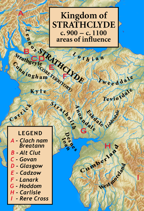
Kingdom of Strathclyde

Strathclyde (lit. "broad valley of the Clyde", Welsh: Ystrad Clud, Latin: Cumbria) was a Brittonic kingdom in northern Britain during the Middle Ages....

Banton, North Lanarkshire

Banton is a small village situated near Kilsyth in North Lanarkshire, Scotland. == History == The Covenanter army under General William Baillie formed...

Fankerton

Fankerton is a small village which lies within the Falkirk council area of Scotland. The village is 1 mile (1.6 km) west of Denny and 6.3 miles (10.1 km...

Braeface

Braeface is a village in Falkirk, Scotland. == External links == Canmore - Braeface site record

Have you been to Birns?

Leave your review of Birns below (or comments, questions and feedback).