Bwlch Corog

Hill, Mountain in Cardiganshire

Wales

Bwlch Corog

On the slopes of Pen Creigiau'r Llan The square is almost totally access land but presents a challenge to get into with only one Geographer - Ian Medcalf - having done so before and who appears to have used a similar route to mine. See <a href="https://www.geograph.org.uk/photo/1206188">SN7494 : Pen Creigiau'r Llan</a>. 

From the south, entry is almost impossible as it would entail tramping through dense forestry and then over barbed fences. From the north would require crossing fenced farmland most of which is not access land and then a steep climb up the hill. From the west may be possible across clear-felled and replanted forestry. 

My chosen route, however,  was from the east from above Pistyll y Llyn. Much of the route was fairly straightforward walking on basic quad bike tracks and the remains of some old water board tracks. The final stage was a different matter, having to trudge across a couple of hundred metres of ankle twisting Molinia grass.

Only a Geograph-er knows the satisfaction that is achieved when getting into a difficult square such as this!
On the slopes of Pen Creigiau'r Llan Credit: John Lucas

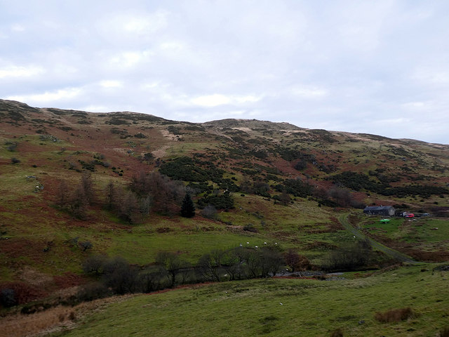
Bwlch Corog is a prominent hill located in Cardiganshire, Wales. Rising to an elevation of approximately 485 meters (1,591 feet), it is a notable feature in the landscape of the region. The hill is situated within the Cambrian Mountains range, which stretches across central Wales.

Bwlch Corog is characterized by its steep and rocky slopes, which provide a challenging terrain for hikers and climbers. Its summit offers breathtaking panoramic views of the surrounding countryside, including the lush valleys and rolling hills of Cardiganshire. On a clear day, it is even possible to catch a glimpse of the Irish Sea in the distance.

The hill is covered in a variety of vegetation, with heather, bracken, and grasses dominating the landscape. This diverse flora provides habitat for various bird species, including the red grouse and peregrine falcon, which can often be spotted soaring above the hill.

Bwlch Corog is also home to a rich history, with evidence of prehistoric settlements and ancient burial sites found in the vicinity. The area has been inhabited for thousands of years, and remnants of old stone walls and structures can still be seen today.

Overall, Bwlch Corog is a captivating natural feature that offers both recreational opportunities and a glimpse into the past. Whether one is seeking a challenging hike, stunning views, or an exploration of local history, this hill in Cardiganshire provides a captivating experience for visitors.

If you have any feedback on the listing, please let us know in the comments section below.

Bwlch Corog Images

Images are sourced within 2km of 52.535652/-3.8715411 or Grid Reference SN7394. Thanks to Geograph Open Source API. All images are credited.

On the slopes of Pen Creigiau'r Llan The square is almost totally access land but presents a challenge to get into with only one Geographer - Ian Medcalf - having done so before and who appears to have used a similar route to mine. See <a href="https://www.geograph.org.uk/photo/1206188">SN7494 : Pen Creigiau'r Llan</a>. 

From the south, entry is almost impossible as it would entail tramping through dense forestry and then over barbed fences. From the north would require crossing fenced farmland most of which is not access land and then a steep climb up the hill. From the west may be possible across clear-felled and replanted forestry. 

My chosen route, however,  was from the east from above Pistyll y Llyn. Much of the route was fairly straightforward walking on basic quad bike tracks and the remains of some old water board tracks. The final stage was a different matter, having to trudge across a couple of hundred metres of ankle twisting Molinia grass.

Only a Geograph-er knows the satisfaction that is achieved when getting into a difficult square such as this!
On the slopes of Pen Creigiau'r Llan
The square is almost totally access land but presents a challenge to get into with only one Geographer - Ian Medcalf - having done so before and who appears to have used a similar route to mine. See SN7494 : Pen Creigiau'r Llan. From the south, entry is almost impossible as it would entail tramping through dense forestry and then over barbed fences. From the north would require crossing fenced farmland most of which is not access land and then a steep climb up the hill. From the west may be possible across clear-felled and replanted forestry. My chosen route, however, was from the east from above Pistyll y Llyn. Much of the route was fairly straightforward walking on basic quad bike tracks and the remains of some old water board tracks. The final stage was a different matter, having to trudge across a couple of hundred metres of ankle twisting Molinia grass. Only a Geograph-er knows the satisfaction that is achieved when getting into a difficult square such as this!
Llyn Conach With Llyn Dwfn just visible lower left.
Llyn Conach
With Llyn Dwfn just visible lower left.
Llyn Conach Viewed from the path to Angler's Retreat.
Llyn Conach
Viewed from the path to Angler's Retreat.
On Pen Creigiau'r Llan Open access land but mostly covered with the dreaded molinia grass.
On Pen Creigiau'r Llan
Open access land but mostly covered with the dreaded molinia grass.
A first view of Pemprys On the road from Ystryd Einion through the forestry on Foel Einion. Cwm Pemprys runs out through the centre of the view.
A first view of Pemprys
On the road from Ystryd Einion through the forestry on Foel Einion. Cwm Pemprys runs out through the centre of the view.
Pen Carreg Gopa Viewed from Foel Einion. Pemprys farmhouse is visible on the right.
Pen Carreg Gopa
Viewed from Foel Einion. Pemprys farmhouse is visible on the right.
Afon Pemprys Looking upstream, the source being just about a mile up the valley.
Afon Pemprys
Looking upstream, the source being just about a mile up the valley.
Afon Pemprys Looking downstream from the vicinity of Pemprys Farm. Afon Pemprys is less than 2 miles in length from its source in Bwlch Corog to its confluence with Afon Einion near Ystryd Einion.
Afon Pemprys
Looking downstream from the vicinity of Pemprys Farm. Afon Pemprys is less than 2 miles in length from its source in Bwlch Corog to its confluence with Afon Einion near Ystryd Einion.
Road leading through the Pemprys farm estate And thence climbing Foel Einion.
Road leading through the Pemprys farm estate
And thence climbing Foel Einion.
Road heading east from Pemprys The well maintained road ends about a ¼ mile ahead on the slopes of Pen Carreg Gopa. Maps show a footpath running directly ahead, towards forestry on Moel y Llyn, but it is unwise to believe everything that maps portray, as recounted by Chris Denny in <a href="https://www.geograph.org.uk/photo/1251159">SN7294 : And the path is where?</a>. I experienced a similar problem with definitive footpaths in the area when trying to access the path from the Moel y Llyn direction, from <a href="https://www.geograph.org.uk/gridref/SN7393">SN7393</a> and as described in <a href="https://www.geograph.org.uk/photo/4036325">SN7393 : 'Bridleway' through the forestry</a>.

It is interesting that the path is not shown on any old large scale maps, nor is it shown on the 1955 2½" or on the 1" 7th series sheet of 1960. The earliest record that I have found is on the 1974 1:50k map. This is unusual as most rights of way in these rural Welsh areas have a historical origin, be it from use as farm or miners' tracks or as drove roads.

You have to wonder why this path was suddenly recorded in the 1970s, effectively running from nowhere to nowhere and of which no trace now remains. It's a pity that Sir Ceredigion is so unresponsive on this, some background information would have been valuable. However, I'm afraid that my dealings with the council, on unrelated matters, have proved to be just as unsatisfactory!
Road heading east from Pemprys
The well maintained road ends about a ¼ mile ahead on the slopes of Pen Carreg Gopa. Maps show a footpath running directly ahead, towards forestry on Moel y Llyn, but it is unwise to believe everything that maps portray, as recounted by Chris Denny in SN7294 : And the path is where?. I experienced a similar problem with definitive footpaths in the area when trying to access the path from the Moel y Llyn direction, from SN7393 and as described in SN7393 : 'Bridleway' through the forestry. It is interesting that the path is not shown on any old large scale maps, nor is it shown on the 1955 2½" or on the 1" 7th series sheet of 1960. The earliest record that I have found is on the 1974 1:50k map. This is unusual as most rights of way in these rural Welsh areas have a historical origin, be it from use as farm or miners' tracks or as drove roads. You have to wonder why this path was suddenly recorded in the 1970s, effectively running from nowhere to nowhere and of which no trace now remains. It's a pity that Sir Ceredigion is so unresponsive on this, some background information would have been valuable. However, I'm afraid that my dealings with the council, on unrelated matters, have proved to be just as unsatisfactory!
Dry-stone wall on the slopes of Pen Carreg Gopa In Cwm Pemprys.
Dry-stone wall on the slopes of Pen Carreg Gopa
In Cwm Pemprys.
Looking up towards Pen Carreg Gopa From Cwm Pemprys.
Looking up towards Pen Carreg Gopa
From Cwm Pemprys.
Pemprys farmhouse The last Geograph visitor to Pemprys was Ian Medcalf in 2014 - <a href="https://www.geograph.org.uk/photo/4057682">SN7194 : Pemprys</a> - and he described the building as a ruin. The Welsh Ruins website <span class="nowrap"><a title="https://www.welshruins.co.uk/pemprys-artists-valley-ceredigion-2013" rel="nofollow ugc noopener" href="https://www.welshruins.co.uk/pemprys-artists-valley-ceredigion-2013">Link</a><img style="margin-left:2px;" alt="External link" title="External link - shift click to open in new window" src="https://s1.geograph.org.uk/img/external.png" width="10" height="10"/></span> described it in 2013 as "A fine deserted longhouse high in the hills. Currently for sale - much vandalised inside, some of it by human hand, some of it by sheep". The farmhouse and surrounding farmland were being offered as separate lots. In 2020 the farmhouse has an occupier and restoration work is underway, including some replacement windows. Coflein has a very good description of the house <span class="nowrap"><a title="https://coflein.gov.uk/en/site/420950/details/pemprys" rel="nofollow ugc noopener" href="https://coflein.gov.uk/en/site/420950/details/pemprys">Link</a><img style="margin-left:2px;" alt="External link" title="External link - shift click to open in new window" src="https://s1.geograph.org.uk/img/external.png" width="10" height="10"/></span> and suggests that a farmstead was established here in the early 16th century with subsequent modifications. 

This is an idyllic and peaceful location in a hidden valley but in 2005 the area was designated as suitable for wind farm development. If the moratorium on land based wind farms is ended, the tranquillity could be destroyed.
Pemprys farmhouse
The last Geograph visitor to Pemprys was Ian Medcalf in 2014 - SN7194 : Pemprys - and he described the building as a ruin. The Welsh Ruins website LinkExternal link described it in 2013 as "A fine deserted longhouse high in the hills. Currently for sale - much vandalised inside, some of it by human hand, some of it by sheep". The farmhouse and surrounding farmland were being offered as separate lots. In 2020 the farmhouse has an occupier and restoration work is underway, including some replacement windows. Coflein has a very good description of the house LinkExternal link and suggests that a farmstead was established here in the early 16th century with subsequent modifications. This is an idyllic and peaceful location in a hidden valley but in 2005 the area was designated as suitable for wind farm development. If the moratorium on land based wind farms is ended, the tranquillity could be destroyed.
A ram and two of his ladies At Pemprys Farm.
A ram and two of his ladies
At Pemprys Farm.
A green yacht at Pemprys A Greta Thunberg cast-off perhaps. 'Act now' it says, but I wonder how much CO2 was expended dragging it up into the hills?
A green yacht at Pemprys
A Greta Thunberg cast-off perhaps. 'Act now' it says, but I wonder how much CO2 was expended dragging it up into the hills?
Pemprys farmhouse The east elevation of the Grade II listed, mid to late 18th century building. See also <a href="https://www.geograph.org.uk/photo/6364045">SN7194 : Pemprys farmhouse</a>.
Pemprys farmhouse
The east elevation of the Grade II listed, mid to late 18th century building. See also SN7194 : Pemprys farmhouse.
Gate on a path on Bwlch Corog
Forestry at the head of Afon Pemprys
Show me another place!

Bwlch Corog is located at Grid Ref: SN7394 (Lat: 52.535652, Lng: -3.8715411)

Unitary Authority: Ceredigion

Police Authority: Dyfed Powys

What 3 Words

///bravest.outfitter.fencing. Near Machynlleth, Powys

Nearby Locations

Bwlch Corog

Related Wikis

Pistyll y Llyn

Pistyll y Llyn is one of the tallest waterfalls in Wales and the United Kingdom. It is a horsetail style set of falls which are located in the Cambrian...

Ystrad Einion

Ystrad Einion or Ystrad-Einion is a small village in the community of Ysgubor-y-coed, Ceredigion, Wales, which is 78.7 miles (126.7 km) from Cardiff and...

Coed Cwm Einion

Coed Cwm Einion is a woodland to the east of the village of Furnace, in Ceredigion, west Wales. It is designated a Site of Special Scientific Interest...

Glandyfi Castle

Glandyfi Castle in Glandyfi, Ceredigion, Wales, is a mock castle dating from the early 19th century. It was built for George Jeffreys, a barrister and...

Derwenlas

Derwenlas is a hamlet in northern Powys, Wales. It is part of the community of Cadfarch. Part of the historic county of Montgomeryshire (Sir Drefaldwyn...

Glandyfi

Glandyfi (formerly anglicised as Glandovey) is a small hamlet in the county of Ceredigion in Wales on the A487 trunk road from Machynlleth to Aberystwyth...

Eglwys Fach

Eglwys Fach, also known as Eglwys-fach or Eglwysfach, is a small village, roughly 12 miles (19 km) outside of Aberystwyth, Ceredigion. It is known for...

Dyfi Furnace

Dyfi Furnace is a restored mid 18th century charcoal fired blast furnace used for smelting iron ore. It has given its name to the adjoining hamlet of Furnace...

Nearby Amenities

Located within 500m of 52.535652,-3.8715411
Bwlch Corog
Created By: Potlatch 0.9a
Natural: peak
Lat/Long: 52.535787/-3.8713212
The data included in this document is from www.openstreetmap.org. The data is made available under ODbL.

Have you been to Bwlch Corog?

Leave your review of Bwlch Corog below (or comments, questions and feedback).