Bryn Brawd

Hill, Mountain in Cardiganshire

Wales

Bryn Brawd

Bryn Brawd Piler triongli ar gopa Bryn Brawd.  Mae'n  debyg y codwyd y piler ar garn o'r Oes Efydd.

A trig point on the summit of Bryn Brawd (trans. hill of the brother). Apparently, the pillar stands  on a Bronze Age cairn.
Bryn Brawd Credit: Alan Richards

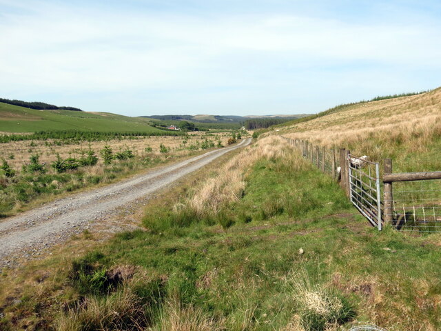
Bryn Brawd is a prominent hill located in the county of Cardiganshire, Wales. Situated in the western part of the county, it forms part of the Cambrian Mountains, which are known for their rugged beauty and rich natural landscapes. The hill stands at an elevation of approximately 1,600 feet (488 meters) and offers breathtaking panoramic views of the surrounding countryside.

Characterized by its steep slopes and rocky terrain, Bryn Brawd attracts outdoor enthusiasts and hikers who are looking to explore the area's natural beauty. The hill is covered in heather and grasses, creating a picturesque landscape that changes with the seasons. Wildflowers dot the hillside during the warmer months, adding bursts of color to the scenery.

The hill is also home to a variety of wildlife, including birds of prey such as buzzards and kestrels, as well as smaller mammals like rabbits and foxes. The surrounding area is known for its diverse flora and fauna, with rare species such as the red kite often spotted in the vicinity.

Bryn Brawd is a popular destination for those seeking outdoor activities such as hillwalking and birdwatching. Its challenging slopes provide an excellent opportunity for experienced hikers to test their skills, while its serene surroundings offer a peaceful retreat from the hustle and bustle of everyday life.

Overall, Bryn Brawd is a captivating natural landmark that offers both physical challenges and tranquil beauty, making it a must-visit destination for nature enthusiasts in Cardiganshire.

If you have any feedback on the listing, please let us know in the comments section below.

Bryn Brawd Images

Images are sourced within 2km of 52.150079/-3.9038229 or Grid Reference SN6951. Thanks to Geograph Open Source API. All images are credited.

Bryn Brawd Piler triongli ar gopa Bryn Brawd.  Mae'n  debyg y codwyd y piler ar garn o'r Oes Efydd.

A trig point on the summit of Bryn Brawd (trans. hill of the brother). Apparently, the pillar stands  on a Bronze Age cairn.
Bryn Brawd
Piler triongli ar gopa Bryn Brawd. Mae'n debyg y codwyd y piler ar garn o'r Oes Efydd. A trig point on the summit of Bryn Brawd (trans. hill of the brother). Apparently, the pillar stands on a Bronze Age cairn.
Coedwigaeth ger Bryn Brawd / Forestry near Bryn Brawd Ffens derfyn goedwigaeth ar rostir islaw Bryn Brawd.

A forestry boundary fence on moorland below Bryn Brawd (trans. hill of the brother).
Coedwigaeth ger Bryn Brawd / Forestry near Bryn Brawd
Ffens derfyn goedwigaeth ar rostir islaw Bryn Brawd. A forestry boundary fence on moorland below Bryn Brawd (trans. hill of the brother).
Craig Curyll Brigiad o greigiau ar rostir a elwir Craig Curyll.

Outcrop of rocks on moorland known as Craig Curyll (trans. hawk rock).
Craig Curyll
Brigiad o greigiau ar rostir a elwir Craig Curyll. Outcrop of rocks on moorland known as Craig Curyll (trans. hawk rock).
Hen adfail / Old ruin Hen adfail ar ochr heol.

An old ruin at the side of a road
Hen adfail / Old ruin
Hen adfail ar ochr heol. An old ruin at the side of a road
Trac yn gadael yr heol / Track exiting the road Trac coedwigaeth ar y dde yn gadael heol fach sy'n mynd i gyfeiriad Llanddewi Brefi.

A forestry track on the right exits a minor road heading towards Llanddewi Brefi (trans. St David's church on the banks of the river Brefi).
Trac yn gadael yr heol / Track exiting the road
Trac coedwigaeth ar y dde yn gadael heol fach sy'n mynd i gyfeiriad Llanddewi Brefi. A forestry track on the right exits a minor road heading towards Llanddewi Brefi (trans. St David's church on the banks of the river Brefi).
Heol fach wledig / Minor rural road Hewl fach wledig yn mynd i gyfeiriad Ffarmers.

A minor road heading in the direction of Ffarmers.
Heol fach wledig / Minor rural road
Hewl fach wledig yn mynd i gyfeiriad Ffarmers. A minor road heading in the direction of Ffarmers.
Ger Esgair Maen / Near Esgair Maen Gât yn rhoi mynediad i blanhigfa gonifferaidd ger Esgair Maen.

A gate gives access to a conifer plantation near Esgair Maen (trans. stone ridge).
Ger Esgair Maen / Near Esgair Maen
Gât yn rhoi mynediad i blanhigfa gonifferaidd ger Esgair Maen. A gate gives access to a conifer plantation near Esgair Maen (trans. stone ridge).
Planhigfa Esgair Maen / Esgair Maen plantation Planhigfa gonifferaidd yn Esgair Main. Y tyle yn y pellter yw Llethr Erwast.

A conifer plantation at Esgair Maen (trans. stone ridge). The hill in the distance is Llethr Erwast.
Planhigfa Esgair Maen / Esgair Maen plantation
Planhigfa gonifferaidd yn Esgair Main. Y tyle yn y pellter yw Llethr Erwast. A conifer plantation at Esgair Maen (trans. stone ridge). The hill in the distance is Llethr Erwast.
Llethr Erwast Golygfa o ochr ddeheuol gopa Llethr Erwast.

A southern view from the summit of Llethr Erwast.
Llethr Erwast
Golygfa o ochr ddeheuol gopa Llethr Erwast. A southern view from the summit of Llethr Erwast.
Llethr Erwast Dringo tuag at gopa Llethr Erwast.

Ascending towards the summit of Llethr Erwast.
Llethr Erwast
Dringo tuag at gopa Llethr Erwast. Ascending towards the summit of Llethr Erwast.
Ffens derfyn ucheldir / Upland boundary fence Gât yn rhoi mynediad i'r rhostir o blanhigfa gonifferaidd.

A gate gives access to the moorland from the conifer plantation.
Ffens derfyn ucheldir / Upland boundary fence
Gât yn rhoi mynediad i'r rhostir o blanhigfa gonifferaidd. A gate gives access to the moorland from the conifer plantation.
Trac coedwigaeth  / Forestry track Trac coedwigaeth ar odre Bryn Mwysau.

A forestry track below Bryn Mwysau (?pleasant hill).
Trac coedwigaeth / Forestry track
Trac coedwigaeth ar odre Bryn Mwysau. A forestry track below Bryn Mwysau (?pleasant hill).
Trac coedwigaeth / Forestry track Trac coedwigaeth ger Drainllwyn-du.

A forestry track near Drainllwyn-du (trans.  black grove of hawthorn trees).
Trac coedwigaeth / Forestry track
Trac coedwigaeth ger Drainllwyn-du. A forestry track near Drainllwyn-du (trans. black grove of hawthorn trees).
Drainllwyn-du Edrych draw tuag at anhedd-dy o'r enw Drainllwyn-du. 

Looking towards  a property known as Drainllwyn-du (trans. black grove of hawthorn trees).
Drainllwyn-du
Edrych draw tuag at anhedd-dy o'r enw Drainllwyn-du. Looking towards a property known as Drainllwyn-du (trans. black grove of hawthorn trees).
Trac coedwigaeth / Forestry track Trac coedwigaeth ger Bronbyrfe. Y gofod  ar y chwith yw'r man lle  mae'r coed eisioes wedi cael eu cynhaeafu a'u hailblannu.

Forestry track near Bronbyrfe.  The space on the left is where trees have already been harvested and replanted.
Trac coedwigaeth / Forestry track
Trac coedwigaeth ger Bronbyrfe. Y gofod ar y chwith yw'r man lle mae'r coed eisioes wedi cael eu cynhaeafu a'u hailblannu. Forestry track near Bronbyrfe. The space on the left is where trees have already been harvested and replanted.
Trac coedigaeth / Forestry track Trac coedwigaeth ger Bryn Moel. Mae'n amlwg bod llawer o waith wedi mynd  i mewn i greu'r trac hwn.

A forestry track near Bryn Moel (trans. bare hilltop).  It's clear that a lot of work went in to create this track.
Trac coedigaeth / Forestry track
Trac coedwigaeth ger Bryn Moel. Mae'n amlwg bod llawer o waith wedi mynd i mewn i greu'r trac hwn. A forestry track near Bryn Moel (trans. bare hilltop). It's clear that a lot of work went in to create this track.
Cynaeafu coed / Harvesting trees Peirianwaith wrthi yn y pellter yn cynaeafu coed ger Bryn Moel.

Machinery in the distance harvesting trees near Bryn Moel (trans. bare hilltop).
Cynaeafu coed / Harvesting trees
Peirianwaith wrthi yn y pellter yn cynaeafu coed ger Bryn Moel. Machinery in the distance harvesting trees near Bryn Moel (trans. bare hilltop).
Carreg Curyll Safle posibl Carreg Curyll. Carreg naturiol ydyw ond oherwydd ei thebygrwydd trawiadol i faenhir mae'n bosibl y'i defnyddiwyd at ddibenion defodol yn ystod yr Oes Neolithig hwyr / Oes Efydd cynnar.   

The possible site of Carreg Curyll (trans. stone of the hawk). A natural rock but because of its striking similarity to a standing stone it may have been used for ritual purposes during the late Neolithic / early Bronze Age.
Carreg Curyll
Safle posibl Carreg Curyll. Carreg naturiol ydyw ond oherwydd ei thebygrwydd trawiadol i faenhir mae'n bosibl y'i defnyddiwyd at ddibenion defodol yn ystod yr Oes Neolithig hwyr / Oes Efydd cynnar. The possible site of Carreg Curyll (trans. stone of the hawk). A natural rock but because of its striking similarity to a standing stone it may have been used for ritual purposes during the late Neolithic / early Bronze Age.
Show me another place!

Bryn Brawd is located at Grid Ref: SN6951 (Lat: 52.150079, Lng: -3.9038229)

Unitary Authority: Ceredigion

Police Authority: Dyfed Powys

What 3 Words

///situation.ferried.emeralds. Near Tregaron, Ceredigion

Nearby Locations

Bryn Brawd

Related Wikis

Pentre-rhew

Pentre-rhew is a hamlet in the community of Llanddewibrefi, Ceredigion, Wales, which is 58.3 miles (93.9 km) from Cardiff and 169.6 miles (272.9 km) from...

St David's Church, Llanddewi Brefi

St David's Church is a Grade II* listed medieval church in the Welsh village of Llanddewi Brefi, 3 miles south of Tregaron in the county of Ceredigion...

Llanddewi Brefi

Llanddewi Brefi (Welsh pronunciation: [ɬanˈðɛwi ˈbrɛvi]) is a village, parish and community of approximately 500 people in Ceredigion, Wales. The village...

Gogoyan

Gogoyan is a hamlet in the community of Llanddewibrefi, Ceredigion, Wales, which is 58.9 miles (94.8 km) from Cardiff and 171.1 miles (275.3 km) from...

Pont Llanio railway station

Pont Llanio railway station was a railway station in Wales on the former Carmarthen to Aberystwyth Line near Llanddewi Brefi. The railway station was built...

Cockshead

Cockshead is a small village in the community of Llanddewi Brefi, Ceredigion, Wales, which is 59.9 miles (96.3 km) from Cardiff and 171.9 miles (276.5...

Llanfair Clydogau

Llanfair Clydogau is a small village and community encompassing 3,232 hectares (7,990 acres), located about 4 miles (6.4 km) north-east of Lampeter on...

Tregaron Hospital

Tregaron Hospital (Welsh: Ysbyty Tregaron) is a community hospital in Tregaron, Wales. It is managed by the Hywel Dda University Health Board. == History... ==

Nearby Amenities

Located within 500m of 52.150079,-3.9038229
Bryn Brawd
Ele: 484
Natural: peak
Lat/Long: 52.1501012/-3.9040673
The data included in this document is from www.openstreetmap.org. The data is made available under ODbL.

Have you been to Bryn Brawd?

Leave your review of Bryn Brawd below (or comments, questions and feedback).