Bryn Rhudd

Hill, Mountain in Cardiganshire

Wales

Bryn Rhudd

Lane south-east of Llanddewi Brefi in Ceredigion Looking east as the former drove road climbs towards Cwm Dulas and Blaendoethie. Beyond that it is unsurfaced in the Doethie valley as far as Soar-y-Mynydd.
Lane south-east of Llanddewi Brefi in Ceredigion Credit: Roger Kidd

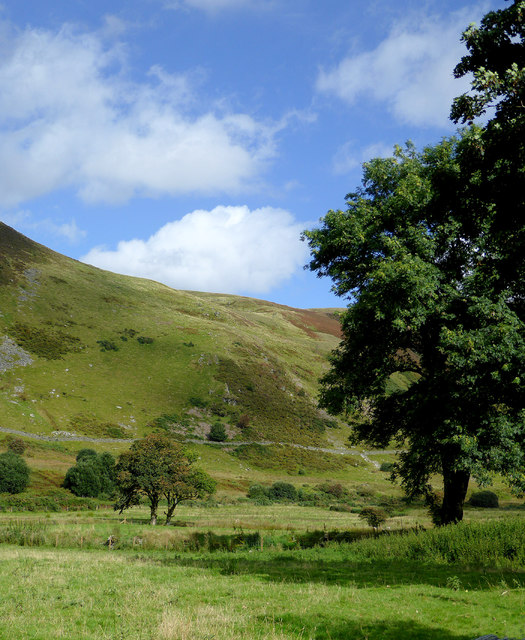
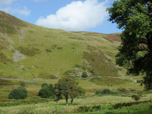
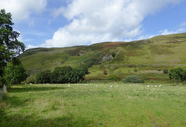
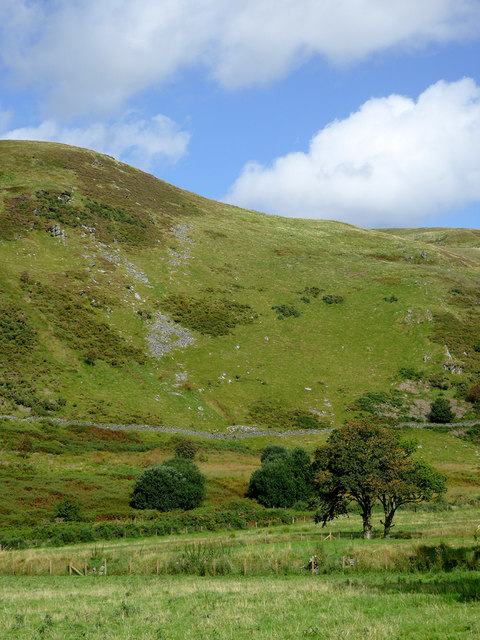
Bryn Rhudd is a prominent hill located in the county of Cardiganshire, Wales. With an elevation of approximately 364 meters (1,194 feet), this mountain is a popular destination for outdoor enthusiasts and nature lovers alike.

Situated in the heart of the Cambrian Mountains, Bryn Rhudd offers breathtaking panoramic views of the surrounding landscape. Its distinct red hue, which translates to "red hill" in Welsh, is attributed to the presence of iron oxide in the soil, giving the mountain a unique and striking appearance.

The hill is covered in heather and grass, providing a habitat for a variety of flora and fauna. It is not uncommon to spot wild birds, such as red kites and peregrine falcons, soaring through the skies above. The area surrounding Bryn Rhudd is also home to several species of small mammals, including rabbits and foxes.

Hikers and walkers are drawn to Bryn Rhudd due to its accessible trails and well-maintained footpaths. The hill offers a range of routes suitable for all abilities, from gentle walks to more challenging ascents. On a clear day, climbers can make out the distant peaks of Snowdonia National Park to the north and the Preseli Hills to the south.

In addition to its natural beauty, Bryn Rhudd holds historical significance. There are remnants of ancient settlements and burial sites in the vicinity, providing a glimpse into the area's past.

Overall, Bryn Rhudd is a captivating mountain that combines stunning scenery, diverse wildlife, and a touch of history, making it a must-visit destination for those exploring the Cardiganshire region.

If you have any feedback on the listing, please let us know in the comments section below.

Bryn Rhudd Images

Images are sourced within 2km of 52.185955/-3.9149959 or Grid Reference SN6955. Thanks to Geograph Open Source API. All images are credited.

Lane south-east of Llanddewi Brefi in Ceredigion Looking east as the former drove road climbs towards Cwm Dulas and Blaendoethie. Beyond that it is unsurfaced in the Doethie valley as far as Soar-y-Mynydd.
Lane south-east of Llanddewi Brefi in Ceredigion
Looking east as the former drove road climbs towards Cwm Dulas and Blaendoethie. Beyond that it is unsurfaced in the Doethie valley as far as Soar-y-Mynydd.
Cwm Brefi in Ceredigion This is about a mile south-east of Llanddewi-Brefi, seen from the former drovers' road to Abergwesyn via Cwm Doethie and Soar-y-mynydd.
Cwm Brefi in Ceredigion
This is about a mile south-east of Llanddewi-Brefi, seen from the former drovers' road to Abergwesyn via Cwm Doethie and Soar-y-mynydd.
Pasture and hillside in Cwm Brefi, Ceredigion This is about a mile south-east of Llanddewi-Brefi, seen from the former drovers' road to Abergwesyn via Cwm Doethie and Soar-y-Mynydd. Caig y Lefel is the rocky outcrop in the middle of the image.
Pasture and hillside in Cwm Brefi, Ceredigion
This is about a mile south-east of Llanddewi-Brefi, seen from the former drovers' road to Abergwesyn via Cwm Doethie and Soar-y-Mynydd. Caig y Lefel is the rocky outcrop in the middle of the image.
Pasture and hillside in Cwm Brefi, Ceredigion This is about a mile south-east of Llanddewi-Brefi, seen from the former drovers' road to Abergwesyn via Cwm Doethie and Soar-y-mynydd.
Pasture and hillside in Cwm Brefi, Ceredigion
This is about a mile south-east of Llanddewi-Brefi, seen from the former drovers' road to Abergwesyn via Cwm Doethie and Soar-y-mynydd.
Narrow lane in Cwm Brefi, Ceredigion This former drovers' road to Abergwesyn via Cwm Doethie Fawr and Soar-y-Mynydd is surfaced as far as Blaendoethie. The following three miles is rough, as far as Soar.
Ahead is the craggy bulk of Craig Ifan.
Narrow lane in Cwm Brefi, Ceredigion
This former drovers' road to Abergwesyn via Cwm Doethie Fawr and Soar-y-Mynydd is surfaced as far as Blaendoethie. The following three miles is rough, as far as Soar. Ahead is the craggy bulk of Craig Ifan.
Narrow lane in Cwm Brefi, Ceredigion This former drovers' road to Abergwesyn via Cwm Doethie Fawr and Soar-y-Mynydd is surfaced as far as Blaendoethie. The following as far as  Soar is not. 
Ahead is the craggy bulk of Craig Ifan.
Narrow lane in Cwm Brefi, Ceredigion
This former drovers' road to Abergwesyn via Cwm Doethie Fawr and Soar-y-Mynydd is surfaced as far as Blaendoethie. The following as far as Soar is not. Ahead is the craggy bulk of Craig Ifan.
Llwybr ceffyl ger Bryn-wernen / A bridleway near Bryn-wernen Llwybr ceffyl yn mynd i lawr y waered ar lan Nant Cou ger Ffarm Bryn-wernen.


A bridleway descending alongside Nant Cou (trans. ravine stream) near Bryn-wernen Farm (trans. willow hill).
Llwybr ceffyl ger Bryn-wernen / A bridleway near Bryn-wernen
Llwybr ceffyl yn mynd i lawr y waered ar lan Nant Cou ger Ffarm Bryn-wernen. A bridleway descending alongside Nant Cou (trans. ravine stream) near Bryn-wernen Farm (trans. willow hill).
Cyffordd o lwybrau ceffyl / A junction of bridleways Cyffordd o lwybrau ceffyl ger Ffarm Bryn-wernen. Yn ddiddorol ddigon nid yw'r llwybr ar y chwith yn cael ei nodi ar Fap OS.

A junction of bridleways near Bryn-wernen Farm (trans. willow hill). Interestingly enough the bridleway branching away on the left is not marked on the OS Map.
Cyffordd o lwybrau ceffyl / A junction of bridleways
Cyffordd o lwybrau ceffyl ger Ffarm Bryn-wernen. Yn ddiddorol ddigon nid yw'r llwybr ar y chwith yn cael ei nodi ar Fap OS. A junction of bridleways near Bryn-wernen Farm (trans. willow hill). Interestingly enough the bridleway branching away on the left is not marked on the OS Map.
Llwybr ceffyl ger Bryn-wernen / A bridleway near Bryn-wernen Llwybr ceffyl ger Ffarm Bryn-wernen. Yn  ddiddorol ddigon nid yw'r llwybr hwn wedi cael ei nodi ar fap OS.

A bridleway near Bryn-wernen Farm (trans. willow hill). Interestingly enough this path is not marked on OS Maps.
Llwybr ceffyl ger Bryn-wernen / A bridleway near Bryn-wernen
Llwybr ceffyl ger Ffarm Bryn-wernen. Yn ddiddorol ddigon nid yw'r llwybr hwn wedi cael ei nodi ar fap OS. A bridleway near Bryn-wernen Farm (trans. willow hill). Interestingly enough this path is not marked on OS Maps.
Road to Llanddewi Brefi in Ceredigion Near Cwm Dulas farm, and looking west towards Llanddewi Brefi along the former drove road from Abergwesyn.
Road to Llanddewi Brefi in Ceredigion
Near Cwm Dulas farm, and looking west towards Llanddewi Brefi along the former drove road from Abergwesyn.
Road to Llanddewi Brefi in Ceredigion Near Cwm Dulas farm, and looking west towards Llanddewi Brefi along the former drove road from Abergwesyn.
Road to Llanddewi Brefi in Ceredigion
Near Cwm Dulas farm, and looking west towards Llanddewi Brefi along the former drove road from Abergwesyn.
Road to Llanddewi Brefi in Ceredigion Near Aberdauddwr farm, and looking west towards Llanddewi Brefi along the former drove road from Abergwesyn.
Road to Llanddewi Brefi in Ceredigion
Near Aberdauddwr farm, and looking west towards Llanddewi Brefi along the former drove road from Abergwesyn.
Road to Llanddewi Brefi in Ceredigion Near Aberdauddwr farm, and looking west towards Llanddewi Brefi along the former drove road from Abergwesyn. The bridge is across a stream which joins the Afon Dulas a few metres off to the left.
Road to Llanddewi Brefi in Ceredigion
Near Aberdauddwr farm, and looking west towards Llanddewi Brefi along the former drove road from Abergwesyn. The bridge is across a stream which joins the Afon Dulas a few metres off to the left.
Cwm Brefi east of Llanddewi Brefi in Ceredigion Near Aberdauddwr farm, and looking west towards Llanddewi Brefi along the former drove road from Abergwesyn. The bridge is across a stream which joins the Afon Dulas a few metres off to the left. Together they continue down the valley as the Afon Brefi.
Cwm Brefi east of Llanddewi Brefi in Ceredigion
Near Aberdauddwr farm, and looking west towards Llanddewi Brefi along the former drove road from Abergwesyn. The bridge is across a stream which joins the Afon Dulas a few metres off to the left. Together they continue down the valley as the Afon Brefi.
Road to Llanddewi Brefi in Ceredigion Approaching Pont Cae-fforest, and looking north-west towards Llanddewi Brefi along the former drove road from Abergwesyn. The Afon Brefi is on the left. Craig y Foelallt is the crag on the right.
Road to Llanddewi Brefi in Ceredigion
Approaching Pont Cae-fforest, and looking north-west towards Llanddewi Brefi along the former drove road from Abergwesyn. The Afon Brefi is on the left. Craig y Foelallt is the crag on the right.
Grazing in Cwm Brefi in Ceredigion Looking north-north-west from the former drove road across the base of the Brefi valley.
Grazing in Cwm Brefi in Ceredigion
Looking north-north-west from the former drove road across the base of the Brefi valley.
Show me another place!

Bryn Rhudd is located at Grid Ref: SN6955 (Lat: 52.185955, Lng: -3.9149959)

Unitary Authority: Ceredigion

Police Authority: Dyfed Powys

What 3 Words

///spoken.requiring.flanked. Near Tregaron, Ceredigion

Nearby Locations

Bryn Rhudd

Related Wikis

Pentre-rhew

Pentre-rhew is a hamlet in the community of Llanddewibrefi, Ceredigion, Wales, which is 58.3 miles (93.9 km) from Cardiff and 169.6 miles (272.9 km) from...

St David's Church, Llanddewi Brefi

St David's Church is a Grade II* listed medieval church in the Welsh village of Llanddewi Brefi, 3 miles south of Tregaron in the county of Ceredigion...

Llanddewi Brefi

Llanddewi Brefi (Welsh pronunciation: [ɬanˈðɛwi ˈbrɛvi]) is a village, parish and community of approximately 500 people in Ceredigion, Wales. The village...

Tregaron Hospital

Tregaron Hospital (Welsh: Ysbyty Tregaron) is a community hospital in Tregaron, Wales. It is managed by the Hywel Dda University Health Board. == History... ==

Pentre, Ceredigion

Pentre is a small area in the community of Tregaron, Ceredigion, Wales, which is 60.4 miles (97.2 km) from Cardiff and 169.5 miles (272.8 km) from London...

Ysgol Henry Richard

Ysgol Henry Richard is a bilingual middle school for pupils aged 3–16 in Ceredigion, Wales. The school is a product of the amalgamation of Ysgol Llanddewi...

Tregaron

Tregaron (Welsh: [treˈɡaːrɔn] "town of St Caron") is an ancient market town in Ceredigion, Wales. It is sited astride the River Brenig, a tributary of...

River Brenig

The River Brenig (Afon Brenig) is a tributary river of the River Teifi and runs through the market town of Tregaron in Ceredigion, Wales. It is formed...

Have you been to Bryn Rhudd?

Leave your review of Bryn Rhudd below (or comments, questions and feedback).