Banc-y-Gwyngoed

Hill, Mountain in Cardiganshire

Wales

Banc-y-Gwyngoed

Craig y Foelallt near Llanddewi Brefi in Ceredigion Looking north-east from near Foelallt Farm. There is a bench seat (and parking) here where you can sit and admire the views across the Afon Brefi valley.
Craig y Foelallt near Llanddewi Brefi in Ceredigion Credit: Roger D Kidd

Banc-y-Gwyngoed is a prominent hill/mountain located in the county of Cardiganshire, Wales. The hill is situated in a rural area, about 5 miles southeast of the town of Aberaeron. Its precise coordinates are 52.2186° N latitude and 4.2366° W longitude.

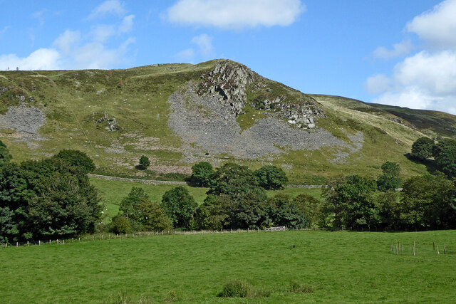
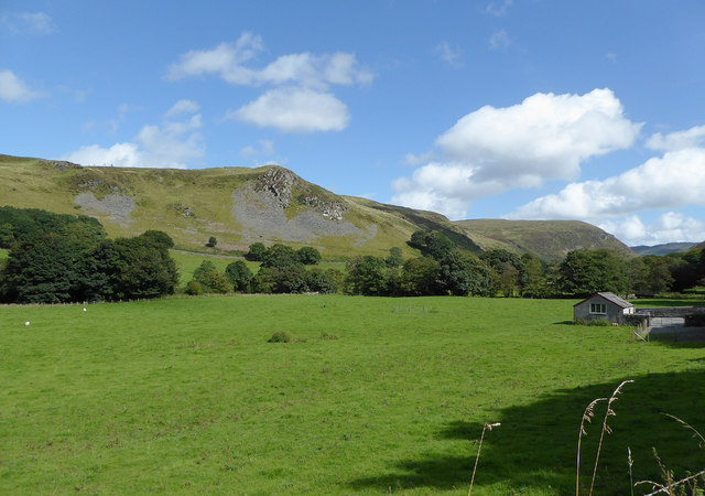
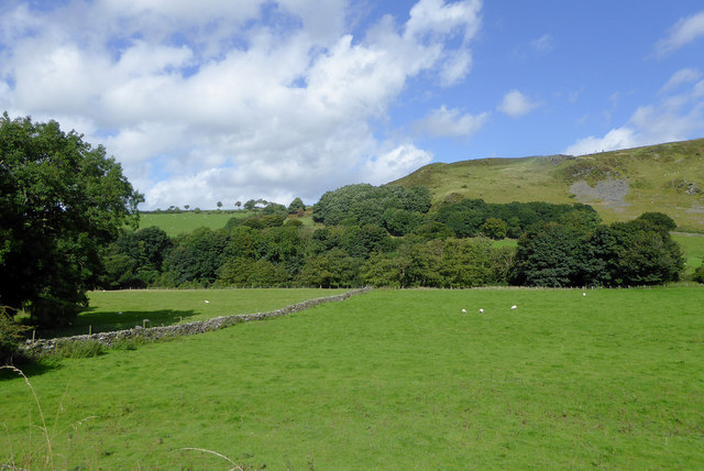
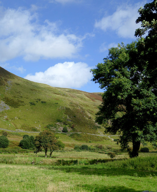
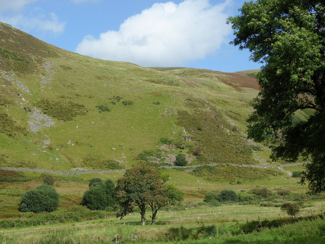
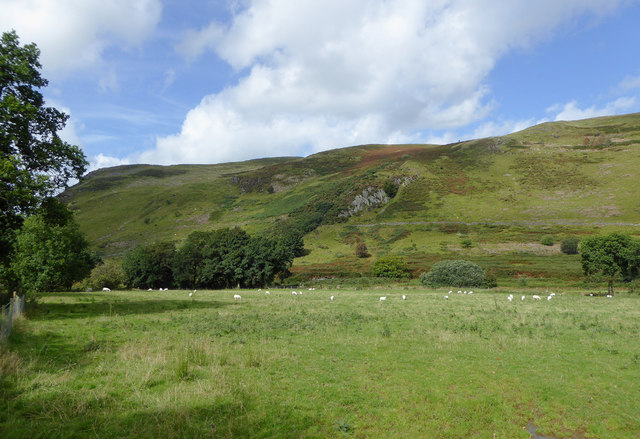
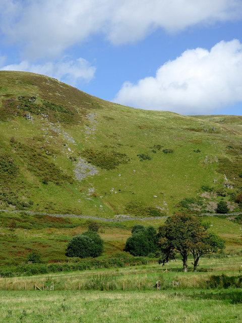
With an elevation of approximately 1,014 feet (309 meters), Banc-y-Gwyngoed offers stunning panoramic views of the surrounding countryside. The hill is known for its rugged terrain, covered in dense vegetation and scattered trees. It is a popular destination for hikers and nature enthusiasts, who are drawn to its natural beauty and tranquility.

Banc-y-Gwyngoed is located within a designated Area of Outstanding Natural Beauty, adding to its appeal for outdoor enthusiasts. The hill is home to a diverse range of wildlife, including various bird species, small mammals, and insects.

The hill has a rich history, with evidence of human activity dating back to ancient times. Archaeological discoveries such as burial mounds and ancient settlements suggest that the area was inhabited in prehistoric and medieval times.

Access to Banc-y-Gwyngoed is relatively easy, with several footpaths and trails leading to its summit. Visitors can enjoy a leisurely walk or a challenging hike, depending on their preference and fitness level. It is advised to wear appropriate footwear and take necessary precautions when exploring the hill, as certain areas can be steep and uneven.

Overall, Banc-y-Gwyngoed is a picturesque hill/mountain that offers a rewarding experience for those seeking natural beauty and outdoor adventure in Cardiganshire.

If you have any feedback on the listing, please let us know in the comments section below.

Banc-y-Gwyngoed Images

Images are sourced within 2km of 52.185647/-3.9300356 or Grid Reference SN6855. Thanks to Geograph Open Source API. All images are credited.

Craig y Foelallt near Llanddewi Brefi in Ceredigion Looking north-east from near Foelallt Farm. There is a bench seat (and parking) here where you can sit and admire the views across the Afon Brefi valley.
Craig y Foelallt near Llanddewi Brefi in Ceredigion
Looking north-east from near Foelallt Farm. There is a bench seat (and parking) here where you can sit and admire the views across the Afon Brefi valley.
Lane south-east of Llanddewi Brefi in Ceredigion Looking east as the former drove road climbs towards Cwm Dulas and Blaendoethie. Beyond that it is unsurfaced in the Doethie valley as far as Soar-y-Mynydd.
Lane south-east of Llanddewi Brefi in Ceredigion
Looking east as the former drove road climbs towards Cwm Dulas and Blaendoethie. Beyond that it is unsurfaced in the Doethie valley as far as Soar-y-Mynydd.
Pant Farm
Pant Farm
The New Inn, Llanddewi Brefi
Pasture in Cwm Brefi, Ceredigion Looking across the valley of the Afon Brefi towards the crags of Craig y Foelallt.
Pasture in Cwm Brefi, Ceredigion
Looking across the valley of the Afon Brefi towards the crags of Craig y Foelallt.
Pasture in Cwm Brefi, Ceredigion Looking across the valley of the Afon Brefi west of the crags on Craig y Foelallt.
Pasture in Cwm Brefi, Ceredigion
Looking across the valley of the Afon Brefi west of the crags on Craig y Foelallt.
Cwm Brefi in Ceredigion This is about a mile south-east of Llanddewi-Brefi, seen from the former drovers' road to Abergwesyn via Cwm Doethie and Soar-y-mynydd.
Cwm Brefi in Ceredigion
This is about a mile south-east of Llanddewi-Brefi, seen from the former drovers' road to Abergwesyn via Cwm Doethie and Soar-y-mynydd.
Pasture and hillside in Cwm Brefi, Ceredigion This is about a mile south-east of Llanddewi-Brefi, seen from the former drovers' road to Abergwesyn via Cwm Doethie and Soar-y-Mynydd. Caig y Lefel is the rocky outcrop in the middle of the image.
Pasture and hillside in Cwm Brefi, Ceredigion
This is about a mile south-east of Llanddewi-Brefi, seen from the former drovers' road to Abergwesyn via Cwm Doethie and Soar-y-Mynydd. Caig y Lefel is the rocky outcrop in the middle of the image.
Pasture and hillside in Cwm Brefi, Ceredigion This is about a mile south-east of Llanddewi-Brefi, seen from the former drovers' road to Abergwesyn via Cwm Doethie and Soar-y-mynydd.
Pasture and hillside in Cwm Brefi, Ceredigion
This is about a mile south-east of Llanddewi-Brefi, seen from the former drovers' road to Abergwesyn via Cwm Doethie and Soar-y-mynydd.
Narrow lane in Cwm Brefi, Ceredigion This former drovers' road to Abergwesyn via Cwm Doethie Fawr and Soar-y-Mynydd is surfaced as far as Blaendoethie. The following three miles is rough, as far as Soar.
Ahead is the craggy bulk of Craig Ifan.
Narrow lane in Cwm Brefi, Ceredigion
This former drovers' road to Abergwesyn via Cwm Doethie Fawr and Soar-y-Mynydd is surfaced as far as Blaendoethie. The following three miles is rough, as far as Soar. Ahead is the craggy bulk of Craig Ifan.
Narrow lane in Cwm Brefi, Ceredigion This former drovers' road to Abergwesyn via Cwm Doethie Fawr and Soar-y-Mynydd is surfaced as far as Blaendoethie. The following as far as  Soar is not. 
Ahead is the craggy bulk of Craig Ifan.
Narrow lane in Cwm Brefi, Ceredigion
This former drovers' road to Abergwesyn via Cwm Doethie Fawr and Soar-y-Mynydd is surfaced as far as Blaendoethie. The following as far as Soar is not. Ahead is the craggy bulk of Craig Ifan.
Ordnance Survey Cut Mark This OS cut mark can be found on the west face of St David's Church. It marks a point 179.090m above mean sea level.
Ordnance Survey Cut Mark
This OS cut mark can be found on the west face of St David's Church. It marks a point 179.090m above mean sea level.
B4343 to Llanddewi-Brefi, Ceredigion Looking south towards Llanddewi-Brefi.
For a leisurely drive between Tregaron and Lampeter I would recommend the B4343 rather than the A485 every time.
B4343 to Llanddewi-Brefi, Ceredigion
Looking south towards Llanddewi-Brefi. For a leisurely drive between Tregaron and Lampeter I would recommend the B4343 rather than the A485 every time.
Pasture north of Llanddewi-Brefi in Ceredigion The sheep are grazing in fields north of the farm at Abercarfan.
Pasture north of Llanddewi-Brefi in Ceredigion
The sheep are grazing in fields north of the farm at Abercarfan.
Pasture north of Llanddewi-Brefi in Ceredigion The sheep are grazing in fields north of the farm at Abercarfan.
Pasture north of Llanddewi-Brefi in Ceredigion
The sheep are grazing in fields north of the farm at Abercarfan.
Water pillar in Llanddewi-Brefi, Ceredigion This water pillar is outside the Foellalt Arms in Llandwei-Brefi. It wasn't there in 2009!
Water pillar in Llanddewi-Brefi, Ceredigion
This water pillar is outside the Foellalt Arms in Llandwei-Brefi. It wasn't there in 2009!
Road (B4343) near Pont Carfan Looking southward from the entrance to Cwm Carfan.
Road (B4343) near Pont Carfan
Looking southward from the entrance to Cwm Carfan.
Show me another place!

Banc-y-Gwyngoed is located at Grid Ref: SN6855 (Lat: 52.185647, Lng: -3.9300356)

Unitary Authority: Ceredigion

Police Authority: Dyfed Powys

What 3 Words

///spent.shoelaces.abode. Near Tregaron, Ceredigion

Nearby Locations

Banc-y-Gwyngoed

Related Wikis

Pentre-rhew

Pentre-rhew is a hamlet in the community of Llanddewibrefi, Ceredigion, Wales, which is 58.3 miles (93.9 km) from Cardiff and 169.6 miles (272.9 km) from...

St David's Church, Llanddewi Brefi

St David's Church is a Grade II* listed medieval church in the Welsh village of Llanddewi Brefi, 3 miles south of Tregaron in the county of Ceredigion...

Llanddewi Brefi

Llanddewi Brefi (Welsh pronunciation: [ɬanˈðɛwi ˈbrɛvi]) is a village, parish and community of approximately 500 people in Ceredigion, Wales. The village...

Pont Llanio railway station

Pont Llanio railway station was a railway station in Wales on the former Carmarthen to Aberystwyth Line near Llanddewi Brefi. The railway station was built...

Have you been to Banc-y-Gwyngoed?

Leave your review of Banc-y-Gwyngoed below (or comments, questions and feedback).