Clogwyn Bwlch-y-maen

Hill, Mountain in Caernarfonshire

Wales

Clogwyn Bwlch-y-maen

Wild camping again Once more on the isthmus between the twin lakes, this time with my two brothers (and no dogs). The evening before had been cool and a bit damp, but we woke to a bright morning, and it stayed that way for most of the day.
Sadly, this location has now been discovered by the fly-campers, probably during the 2020/2021 Coronavirus restrictions, during which holidays abroad have been greatly restricted and people have found places in the UK. There are several holes in the turf where rocks have been pulled up, a firepit has been created (just to the right of the blue tent) and nearby trees are being hacked around for firewood - the dismembered tree branch lying on the floor was nothing to do with us. I also had to remove a piece of steel barbecue equipment from the firepit and carry it back to the car.
Last time I was here was 15 years ago <a href="https://www.geograph.org.uk/photo/1662449">SH6853 : Wild campsite on the isthmus between the lakes</a>. The view direction of this current photo is different to that one, we are now looking at the steep E face of Carnedd y Cribiau.
Wild camping again Credit: Richard Law

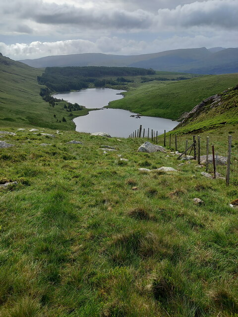
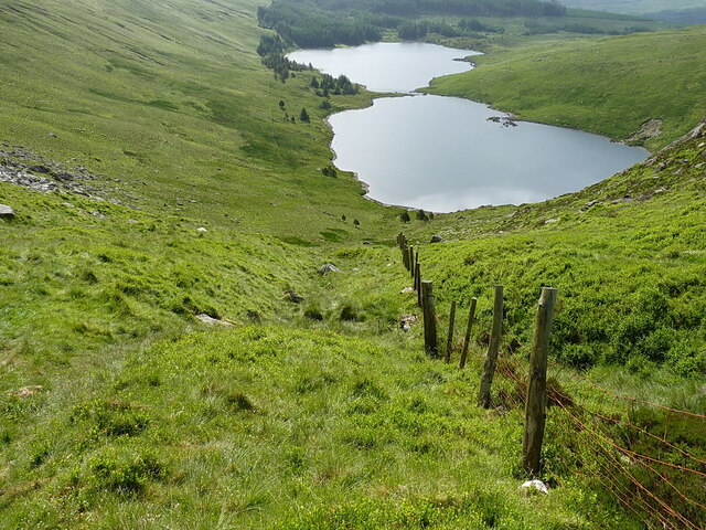
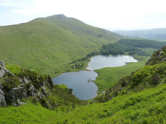
Clogwyn Bwlch-y-maen is a hill located in the county of Caernarfonshire in North Wales, United Kingdom. It is part of the Snowdonia National Park and is situated near the village of Llanberis. With an elevation of 625 meters (2,051 feet), it is a prominent feature in the landscape.

The hill offers stunning panoramic views of the surrounding area, including the famous Snowdon Mountain, the highest peak in Wales. From the summit of Clogwyn Bwlch-y-maen, visitors can also enjoy breathtaking vistas of the Llyn Peninsula, the Menai Strait, and the Irish Sea.

The terrain of Clogwyn Bwlch-y-maen is characterized by rocky outcrops and steep slopes, making it a popular destination for hikers, mountaineers, and nature enthusiasts. The hill is traversed by several walking trails, including the Snowdon Horseshoe, a challenging circular route that takes in Clogwyn Bwlch-y-maen along with other peaks in the area.

The hill is also known for its rich biodiversity, with a variety of plant and animal species calling it home. It provides habitats for rare and protected species, including mountain birds such as the chough and the peregrine falcon.

Clogwyn Bwlch-y-maen holds cultural significance as well, with historical landmarks and remnants of old mining activities dotting its slopes. It is a place where visitors can immerse themselves in the natural beauty and heritage of the Welsh countryside.

If you have any feedback on the listing, please let us know in the comments section below.

Clogwyn Bwlch-y-maen Images

Images are sourced within 2km of 53.069095/-3.9730944 or Grid Reference SH6754. Thanks to Geograph Open Source API. All images are credited.

Wild camping again Once more on the isthmus between the twin lakes, this time with my two brothers (and no dogs). The evening before had been cool and a bit damp, but we woke to a bright morning, and it stayed that way for most of the day.
Sadly, this location has now been discovered by the fly-campers, probably during the 2020/2021 Coronavirus restrictions, during which holidays abroad have been greatly restricted and people have found places in the UK. There are several holes in the turf where rocks have been pulled up, a firepit has been created (just to the right of the blue tent) and nearby trees are being hacked around for firewood - the dismembered tree branch lying on the floor was nothing to do with us. I also had to remove a piece of steel barbecue equipment from the firepit and carry it back to the car.
Last time I was here was 15 years ago <a href="https://www.geograph.org.uk/photo/1662449">SH6853 : Wild campsite on the isthmus between the lakes</a>. The view direction of this current photo is different to that one, we are now looking at the steep E face of Carnedd y Cribiau.
Wild camping again
Once more on the isthmus between the twin lakes, this time with my two brothers (and no dogs). The evening before had been cool and a bit damp, but we woke to a bright morning, and it stayed that way for most of the day. Sadly, this location has now been discovered by the fly-campers, probably during the 2020/2021 Coronavirus restrictions, during which holidays abroad have been greatly restricted and people have found places in the UK. There are several holes in the turf where rocks have been pulled up, a firepit has been created (just to the right of the blue tent) and nearby trees are being hacked around for firewood - the dismembered tree branch lying on the floor was nothing to do with us. I also had to remove a piece of steel barbecue equipment from the firepit and carry it back to the car. Last time I was here was 15 years ago SH6853 : Wild campsite on the isthmus between the lakes. The view direction of this current photo is different to that one, we are now looking at the steep E face of Carnedd y Cribiau.
Close to the summit of Bwlch Rhiw'r Ychen Almost the same view as <a href="https://www.geograph.org.uk/photo/6480698">SH6754 : Climbing up to Bwlch Rhiw'r Ychen</a>, but this time on a brighter day in mid summer. The water level in the lakes is much lower, and the stepping stones were visible this year.
Close to the summit of Bwlch Rhiw'r Ychen
Almost the same view as SH6754 : Climbing up to Bwlch Rhiw'r Ychen, but this time on a brighter day in mid summer. The water level in the lakes is much lower, and the stepping stones were visible this year.
Llyn Carnedd y Cribau A tiny pool in a rocky basin almost at the summit of Carnedd y Cribiau, which neatly provides a foreground for the view to the Snowdon massif and the road over Pen y Pass
Llyn Carnedd y Cribau
A tiny pool in a rocky basin almost at the summit of Carnedd y Cribiau, which neatly provides a foreground for the view to the Snowdon massif and the road over Pen y Pass
Track in the forest The forest track here crosses an area marked as Sarn Diwaunydd ('poor causeway') which rather suggests this was boggy or difficult ground at one time prior to the planting of the trees.
Track in the forest
The forest track here crosses an area marked as Sarn Diwaunydd ('poor causeway') which rather suggests this was boggy or difficult ground at one time prior to the planting of the trees.
The lower slopes of Llechwedd Garnedd Walking beside the broken fenceline just above the twin lakes of Llynau Diwaunydd
The lower slopes of Llechwedd Garnedd
Walking beside the broken fenceline just above the twin lakes of Llynau Diwaunydd
The craggy face of Clogwyn Bwlch-y-maen This was probably once a heavily glaciated headwall to the cwm, but several thousand years of weathering have softened the rocky outcrop somewhat.
The craggy face of Clogwyn Bwlch-y-maen
This was probably once a heavily glaciated headwall to the cwm, but several thousand years of weathering have softened the rocky outcrop somewhat.
The steep eastern side of Carnedd y Cribau Steep glaciated rocks at the top of the slope, and a large hillside of weathered boulders and scree below that. It would be tough country to try to cross.
The steep eastern side of Carnedd y Cribau
Steep glaciated rocks at the top of the slope, and a large hillside of weathered boulders and scree below that. It would be tough country to try to cross.
Steep climb up from the lakes This photo shows the steep route up the gully above Llynau Diwaunydd, which shortly opens up onto the saddle of Bwlch Rhiw'r Ychen. On a warm day, you could easily overheat stomping up this way.
Steep climb up from the lakes
This photo shows the steep route up the gully above Llynau Diwaunydd, which shortly opens up onto the saddle of Bwlch Rhiw'r Ychen. On a warm day, you could easily overheat stomping up this way.
Uphill towards Carnedd y Cribau The easiest route up the hillside follows the fenceline, where walkers have worn a bit of a path.
Uphill towards Carnedd y Cribau
The easiest route up the hillside follows the fenceline, where walkers have worn a bit of a path.
Down the fence towards Bwlch Rhiw'r Ychen The bwlch lies at the low point between Moel Siabod (out of sight to the right) and Carnedd y Cribau which is behind me. The obvious craggy outcrop just to the right of my brothers is <a href="https://www.geograph.org.uk/photo/7219782">SH6754 : The craggy face of Clogwyn Bwlch-y-maen</a>
Down the fence towards Bwlch Rhiw'r Ychen
The bwlch lies at the low point between Moel Siabod (out of sight to the right) and Carnedd y Cribau which is behind me. The obvious craggy outcrop just to the right of my brothers is SH6754 : The craggy face of Clogwyn Bwlch-y-maen
East from Carnedd y Cribau Looking down a steep gully on the hillside near the summit of Carnedd y Cribau, to the twin lakes in the cwm, and Carnedd Moel siabod beyond.
East from Carnedd y Cribau
Looking down a steep gully on the hillside near the summit of Carnedd y Cribau, to the twin lakes in the cwm, and Carnedd Moel siabod beyond.
Summit rocks & boulders on Carnedd y Cribau One of two possible highest points for the hill; I was standing pretty much on the other one; they're only a few yards apart. One of the points is described in the hills database at <span class="nowrap"><a title="http://www.hill-bagging.co.uk/mountaindetails.php?qu=S&rf=3341" rel="nofollow ugc noopener" href="http://www.hill-bagging.co.uk/mountaindetails.php?qu=S&rf=3341">Link</a><img style="margin-left:2px;" alt="External link" title="External link - shift click to open in new window" src="https://s1.geograph.org.uk/img/external.png" width="10" height="10"/></span> as 'Rocky knoll with a few rocks from a collapsed cairn' whilst the one seen here is a 'Boulder 10m SE' and definitely looked higher to me on the day.
Summit rocks & boulders on Carnedd y Cribau
One of two possible highest points for the hill; I was standing pretty much on the other one; they're only a few yards apart. One of the points is described in the hills database at LinkExternal link as 'Rocky knoll with a few rocks from a collapsed cairn' whilst the one seen here is a 'Boulder 10m SE' and definitely looked higher to me on the day.
Llyn Carnedd y Cribau A very similar view to <a href="https://www.geograph.org.uk/photo/7205023">SH6753 : Llyn Carnedd y Cribau</a>, but looking slightly further north to the Glyderau range, with Tryfan just visible on the right.
Llyn Carnedd y Cribau
A very similar view to SH6753 : Llyn Carnedd y Cribau, but looking slightly further north to the Glyderau range, with Tryfan just visible on the right.
A pond with a view Part way down the southern ridge of Carnedd y Cribau, this shallow pond provides a foreground for the view to the Snowdon group.
A pond with a view
Part way down the southern ridge of Carnedd y Cribau, this shallow pond provides a foreground for the view to the Snowdon group.
View up Y Cribau from Bwlch Maen Pig A view back up the hillside towards the summit area of the hill
View up Y Cribau from Bwlch Maen Pig
A view back up the hillside towards the summit area of the hill
Looking down the fence on Y Cribau
Moorland on Y Cribau On the descent from Carnedd y Cribau towards the trackway that connects the Nant Gwynant and Blaenau Dolwyddelan.
Moorland on Y Cribau
On the descent from Carnedd y Cribau towards the trackway that connects the Nant Gwynant and Blaenau Dolwyddelan.
Descending Y Cribau My brothers descending from Carnedd Y Cribau hill, after we'd had a night out camping by the lake at <a href="https://www.geograph.org.uk/photo/7205018">SH6853 : Wild camping again</a>
Descending Y Cribau
My brothers descending from Carnedd Y Cribau hill, after we'd had a night out camping by the lake at SH6853 : Wild camping again
Show me another place!

Clogwyn Bwlch-y-maen is located at Grid Ref: SH6754 (Lat: 53.069095, Lng: -3.9730944)

Unitary Authority: Conwy

Police Authority: North Wales

What 3 Words

///photocopy.trimmer.embraced. Near Blaenau-Ffestiniog, Gwynedd

Nearby Locations

Clogwyn Bwlch-y-maen

Related Wikis

Arfon (cantref)

Arfon (or Arvon) was a mediaeval Welsh cantref in north-west Wales. It was the core of the kingdom of Gwynedd. Later it was included in the new county...

District of Arfon

The Borough of Arfon was local government district with borough status from 1974 to 1996, being one of five districts in the county of Gwynedd, north-west...

Pen-y-Gwryd

Pen-y-Gwryd is a pass at the head of Nantygwryd and Nant Cynnyd rivers close to the foot of Snowdon in Gwynedd, Wales. The area is located at the junction...

Nant Cynnyd

The Nant y Cynnyd is a small river in Gwynedd, north Wales, starting near the Pen-y-Gwryd hotel near Capel Curig. The Ordnance Survey map is not completely...

Nearby Amenities

Located within 500m of 53.069095,-3.9730944
Clogwyn Bwlch-y-maen
Place: locality
Source: OS 1:25k
Lat/Long: 53.0698433/-3.9763175
Bwlch Rhiw'r Ychen
Natural: saddle
Source: OS 1:25k
Lat/Long: 53.0683478/-3.976575
Barrier: stile
Lat/Long: 53.0689482/-3.9771259
The data included in this document is from www.openstreetmap.org. The data is made available under ODbL.

Have you been to Clogwyn Bwlch-y-maen?

Leave your review of Clogwyn Bwlch-y-maen below (or comments, questions and feedback).