Am Binnein

Hill, Mountain in Inverness-shire

Scotland

Am Binnein

A9, Glen Truim Prior to planned upgrade to a dual carriageway.
A9, Glen Truim Credit: Richard Webb

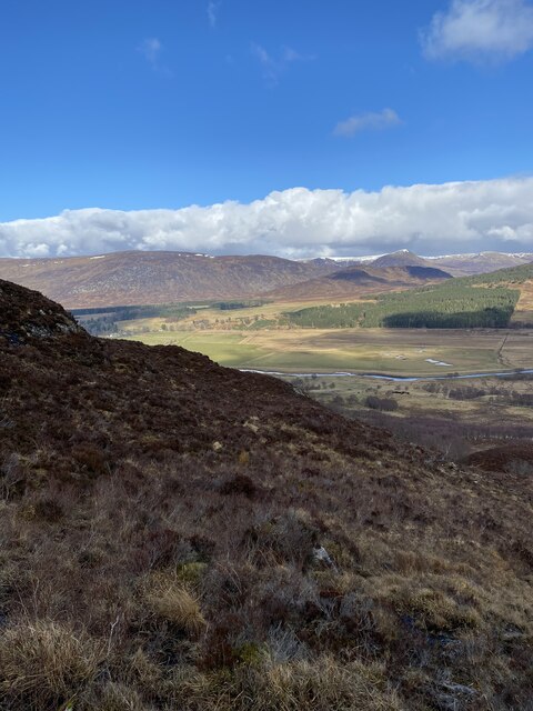
Am Binnein is a prominent hill located in the county of Inverness-shire, Scotland. It is part of the Monadhliath Mountains, which stretch across the eastern part of the Highlands. Standing at an elevation of 889 meters (2,917 feet), Am Binnein offers breathtaking panoramic views of the surrounding landscape.

The hill is a popular destination for hikers and outdoor enthusiasts due to its accessibility and stunning scenery. Its moderate difficulty level makes it suitable for both experienced climbers and those new to hillwalking. The path to the summit is well-defined, although some sections can be steep and rocky, requiring a bit of scrambling.

The summit of Am Binnein is marked by a cairn, offering a rewarding spot to rest and soak in the awe-inspiring vistas. On a clear day, one can enjoy sweeping views of the Cairngorms National Park, the Moray Firth, and the Great Glen.

The surrounding area is rich in wildlife, with red deer, mountain hares, and golden eagles often spotted by visitors. The hillside is adorned with heather and scattered with boulders, creating a rugged and wild atmosphere.

Am Binnein is easily accessible from the nearby town of Aviemore, with several walking routes leading from different starting points. The hill is best tackled during the drier months, as the weather can be unpredictable and conditions underfoot can become challenging during wetter periods.

If you have any feedback on the listing, please let us know in the comments section below.

Am Binnein Images

Images are sourced within 2km of 56.991143/-4.1960852 or Grid Reference NN6691. Thanks to Geograph Open Source API. All images are credited.

A9, Glen Truim Prior to planned upgrade to a dual carriageway.
A9, Glen Truim
Prior to planned upgrade to a dual carriageway.
Flat valley bottom of Glen Truim The River Truim which flows through the valley is unseen in the image, recorded from the A9 trunk road.
The hill which rises beyond is un-named on OS maps.
Flat valley bottom of Glen Truim
The River Truim which flows through the valley is unseen in the image, recorded from the A9 trunk road. The hill which rises beyond is un-named on OS maps.
Road towards Crubenmore
The valley of the River Truim General Wade's Military Road runs along the foot of the hill on the other side of the valley
The valley of the River Truim
General Wade's Military Road runs along the foot of the hill on the other side of the valley
A9, northbound, Crubenmore The A9 is a strategic link between the Highlands of Scotland and the Central Belt. It runs 279 miles from junction 5 of the M9 at Polmont to Scrabster. Originally it ran from Edinburgh.
<span class="nowrap"><a title="https://www.sabre-roads.org.uk/wiki/index.php?title=A9" rel="nofollow ugc noopener" href="https://www.sabre-roads.org.uk/wiki/index.php?title=A9">Link</a><img style="margin-left:2px;" alt="External link" title="External link - shift click to open in new window" src="https://s1.geograph.org.uk/img/external.png" width="10" height="10"/></span>
A9, northbound, Crubenmore
The A9 is a strategic link between the Highlands of Scotland and the Central Belt. It runs 279 miles from junction 5 of the M9 at Polmont to Scrabster. Originally it ran from Edinburgh. LinkExternal link
A9, northbound The A9 is a strategic link between the Highlands of Scotland and the Central Belt. It runs 279 miles from junction 5 of the M9 at Polmont to Scrabster. Originally it ran from Edinburgh.
<span class="nowrap"><a title="https://www.sabre-roads.org.uk/wiki/index.php?title=A9" rel="nofollow ugc noopener" href="https://www.sabre-roads.org.uk/wiki/index.php?title=A9">Link</a><img style="margin-left:2px;" alt="External link" title="External link - shift click to open in new window" src="https://s1.geograph.org.uk/img/external.png" width="10" height="10"/></span>
A9, northbound
The A9 is a strategic link between the Highlands of Scotland and the Central Belt. It runs 279 miles from junction 5 of the M9 at Polmont to Scrabster. Originally it ran from Edinburgh. LinkExternal link
Road towards Crubenmore
Road near Crubenmore Lodge
Grazing land, Glen Truim
Trig point on Cruben Beag
Angry cows near Crubenmore
View to Am Binnein
View to Am Binnein
Cruban Beag A craggy summit in the Cairngorms
Cruban Beag
A craggy summit in the Cairngorms
Stunning views towards the River Spey
Deer fence
Deer fence
Stunning views South
Cruban Beag Trig Point in the far distance
Cruban Beag Trig Point Flush Bracket 10757
Show me another place!

Am Binnein is located at Grid Ref: NN6691 (Lat: 56.991143, Lng: -4.1960852)

Unitary Authority: Highland

Police Authority: Highlands and Islands

What 3 Words

///calculating.stub.libraries. Near Newtonmore, Highland

Nearby Locations

Am Binnein Crùban Mòr

Related Wikis

Etteridge

Etteridge (Scottish Gaelic: Eadrais) is a small remote hamlet, situated close to Loch Etteridge in Inverness-shire, Scottish Highlands and is in the Scottish...

Catlodge

Catlodge (Scottish Gaelic: Caitleag) is a hamlet, in the district of Newtonmore in Inverness-shire, Scottish Highlands and is in the Scottish council...

River Truim

The River Truim (Abhainn Truim in Gaelic) is a right bank tributary of the River Spey in the Scottish Highlands. Its headwaters meet to the north of the...

Battle of Invernahavon

The Battle of Invernahavon was a Scottish clan battle between the Clan Cameron and the confederation of Clan Chattan that consisted of the Clan Mackintosh...

Have you been to Am Binnein?

Leave your review of Am Binnein below (or comments, questions and feedback).