Bennan

Hill, Mountain in Kirkcudbrightshire

Scotland

Bennan

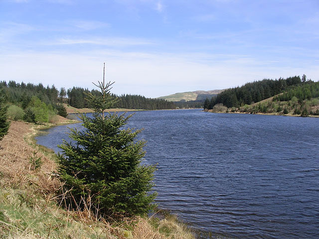
The Southern Upland Way near Blackmark Plantation
The Southern Upland Way near Blackmark Plantation Credit: Dave Kelly

Bennan is a prominent hill located in the Kirkcudbrightshire region of Scotland. Standing at an elevation of 288 meters (945 feet), Bennan offers stunning panoramic views of the surrounding landscape. The hill is a popular destination for hikers and outdoor enthusiasts, with a well-defined trail leading to the summit.

Bennan is characterized by its rugged terrain, rocky outcrops, and heather-covered slopes. The hill is also home to a diverse range of wildlife, including red deer, birds of prey, and various species of plants and flowers.

In addition to its natural beauty, Bennan is also steeped in history, with archaeological sites dating back to ancient times. Visitors can explore the remnants of ancient settlements, burial cairns, and other historical landmarks scattered throughout the hill.

Overall, Bennan offers a unique and rewarding hiking experience for those looking to immerse themselves in the natural beauty and history of the Kirkcudbrightshire region. Its picturesque views, diverse wildlife, and rich history make it a must-visit destination for outdoor enthusiasts and history buffs alike.

If you have any feedback on the listing, please let us know in the comments section below.

Bennan Images

Images are sourced within 2km of 55.190468/-4.1062333 or Grid Reference NX6690. Thanks to Geograph Open Source API. All images are credited.

The Southern Upland Way near Blackmark Plantation
Southern Upland Way by Culmark Farm
Lochan near Stroanfreggan Burn (south end)
Lochan near Stroanfreggan Burn (north end)
Carroch Lane The term "lane" is often synonymous with "burn" in this part of Scotland.
Carroch Lane
The term "lane" is often synonymous with "burn" in this part of Scotland.
Cows on the road, near Fingland
Carroch A remote farm, seen from the B729 Kendoon to Moniaive road. Carroch Fell <a href="https://www.geograph.org.uk/gridref/NX6792">NX6792</a> in the distance.
Carroch
A remote farm, seen from the B729 Kendoon to Moniaive road. Carroch Fell NX6792 in the distance.
Moorland near Stroanfreggan A young conifer plantation has been established in the walled paddock.
Moorland near Stroanfreggan
A young conifer plantation has been established in the walled paddock.
Moorland road near Fingland The improved land in the right middle distance is round Fingland Farm <a href="https://www.geograph.org.uk/gridref/NX6690">NX6690</a>.
Moorland road near Fingland
The improved land in the right middle distance is round Fingland Farm NX6690.
Carroch A remote farm, seen from the B729 Kendoon to Moniaive road. Carroch Fell <a href="https://www.geograph.org.uk/gridref/NX6792">NX6792</a> in the distance.
Carroch
A remote farm, seen from the B729 Kendoon to Moniaive road. Carroch Fell NX6792 in the distance.
The Culmark Hare A hare sits on the Southern Upland Way just north of Culmark
The Culmark Hare
A hare sits on the Southern Upland Way just north of Culmark
Ruined wall and fence line near Culmark The hill is Marscalloch Hill 381m in NX6192
Ruined wall and fence line near Culmark
The hill is Marscalloch Hill 381m in NX6192
Looking south towards Culmark Picture taken from the Southern Upland Way.
Looking south towards Culmark
Picture taken from the Southern Upland Way.
Southern Upland Way near Culmark Looking north towards the steep eastern shoulder of Beninner Gairy NX6097
Southern Upland Way near Culmark
Looking north towards the steep eastern shoulder of Beninner Gairy NX6097
Dead tree at Culmark This tree is a feature of the isolated farm, passed by the Southern Upland Way.
Dead tree at Culmark
This tree is a feature of the isolated farm, passed by the Southern Upland Way.
Loch on the B729 near Blackmark
Rough grazing, Fingland Lane A chunk of the rapidly diminishing area of infertile, waterlogged Galloway rough grazing.
Rough grazing, Fingland Lane
A chunk of the rapidly diminishing area of infertile, waterlogged Galloway rough grazing.
Tussocks Typical acid rough grazing in Galloway but a disappearing landscape as conifer plantations are expanding again.
Tussocks
Typical acid rough grazing in Galloway but a disappearing landscape as conifer plantations are expanding again.
Show me another place!

Bennan is located at Grid Ref: NX6690 (Lat: 55.190468, Lng: -4.1062333)

Unitary Authority: Dumfries and Galloway

Police Authority: Dumfries and Galloway

What 3 Words

///divorcing.stared.slice. Near Thornhill, Dumfries & Galloway

Nearby Locations

Bennan Fingland Hill

Related Wikis

Lochinvar

Lochinvar (or Lan Var) is a loch in the civil parish of Dalry in the historic county of Kirkcudbrightshire, Dumfries and Galloway Scotland. It is located...

Carsphairn and Scaur Hills

The Carsphairn and Scaur Hills are the western and eastern hills respectively of a hill range in the Southern Uplands of Scotland. Ordnance Survey maps...

Loch Howie

Loch Howie is a small, narrow, upland freshwater loch on the north side of Blackcraig Hill, approximately 18 miles (29 km) west of Dumfries, Scotland....

Earlstoun Castle

Earlstoun Castle, sometimes spelled Earlston Castle, is a derelict tower house near St John's Town of Dalry in Dumfries and Galloway, Scotland. Built in...

Nearby Amenities

Located within 500m of 55.190468,-4.1062333
Bennan
Ele: 362.1
Natural: peak
Note: OS7: 1188 feet
Source: OS7
Lat/Long: 55.1911463/-4.1063762
Power: pole
Lat/Long: 55.18607/-4.1057681
Power: pole
Lat/Long: 55.186321/-4.1048196
Power: pole
Lat/Long: 55.1865697/-4.103889
Power: pole
Lat/Long: 55.1868365/-4.1028799
Power: pole
Lat/Long: 55.1871082/-4.1018602
Power: pole
Lat/Long: 55.1873726/-4.1008468
The data included in this document is from www.openstreetmap.org. The data is made available under ODbL.

Have you been to Bennan?

Leave your review of Bennan below (or comments, questions and feedback).