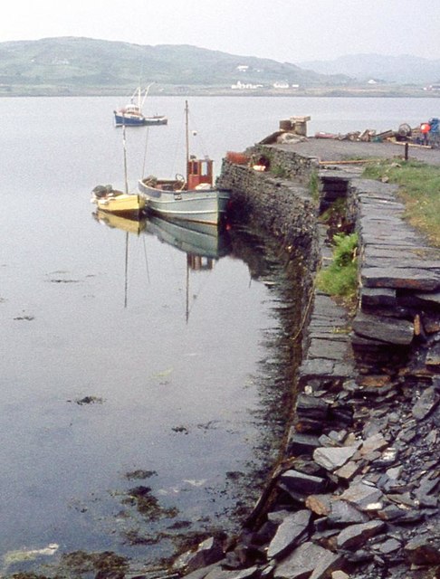
Balvicar

Settlement in Argyllshire

Scotland

Balvicar

Seil - Sheep hold-up A short hiatus on our way down the B8003 through Seil to catch the ferry at Cuan to travel over to Luing. It was only a brief hold-up though as the sheep were soon steered off to the right.
Seil - Sheep hold-up Credit: Rob Farrow

Balvicar is a picturesque village located in the county of Argyllshire, Scotland. Situated on the eastern coast of the Isle of Seil, it is nestled amidst stunning natural landscapes and offers breathtaking views of the surrounding mountains and sea.

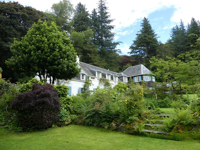
The village is known for its tranquility and serene atmosphere, making it a popular destination for those seeking a peaceful retreat. Its charm lies in the quaint and traditional whitewashed cottages that line the narrow streets, creating a postcard-worthy setting.

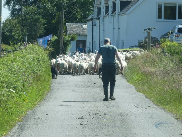
Balvicar is also a thriving fishing community, with its roots dating back to ancient times. The local fishermen continue to ply their trade, bringing in an abundance of fresh seafood that is highly regarded in the region. Visitors can sample the catch of the day at the village's seafood restaurants or purchase it directly from the fishermen's cooperative.

Nature enthusiasts will find plenty to explore in Balvicar and its surroundings. The area is home to diverse wildlife, and birdwatchers can spot various species along the coastline. The nearby hills and forests offer numerous hiking trails, allowing visitors to soak up the natural beauty of the region.

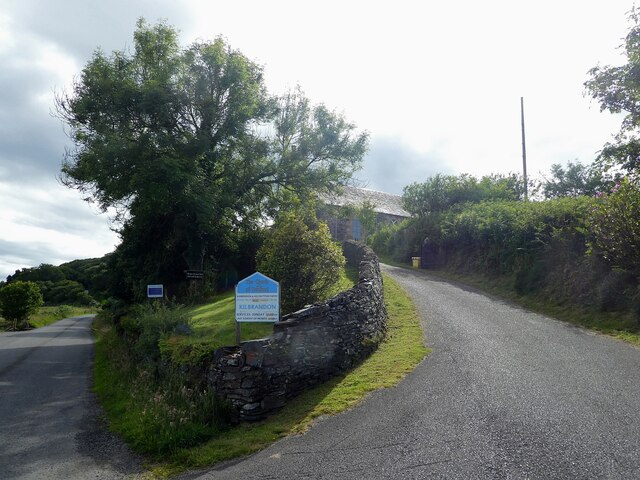
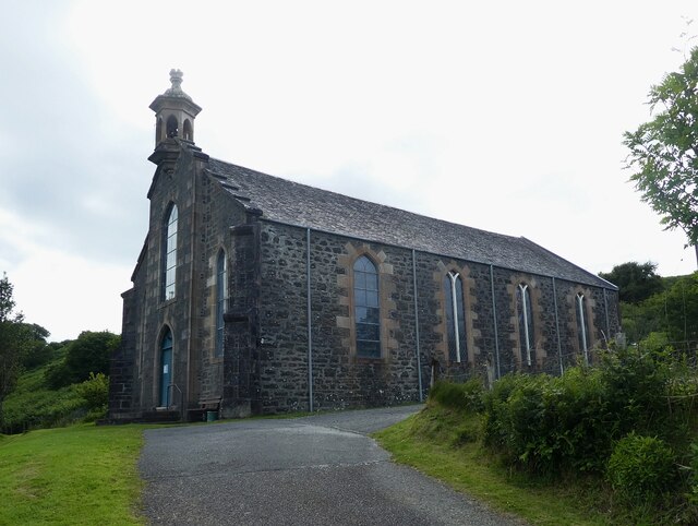
For history enthusiasts, Balvicar boasts several historic sites, including the ruins of Kilbrandon Church, which dates back to the 13th century. This ancient church provides a glimpse into the area's rich past and is a must-visit for those interested in exploring the local heritage.

Overall, Balvicar in Argyllshire offers a harmonious blend of natural beauty, rich history, and a welcoming community, making it an ideal destination for those seeking a peaceful and idyllic Scottish getaway.

If you have any feedback on the listing, please let us know in the comments section below.

Balvicar Images

Images are sourced within 2km of 56.290577/-5.615125 or Grid Reference NM7616. Thanks to Geograph Open Source API. All images are credited.

Seil - Sheep hold-up A short hiatus on our way down the B8003 through Seil to catch the ferry at Cuan to travel over to Luing. It was only a brief hold-up though as the sheep were soon steered off to the right.
Seil - Sheep hold-up
A short hiatus on our way down the B8003 through Seil to catch the ferry at Cuan to travel over to Luing. It was only a brief hold-up though as the sheep were soon steered off to the right.
Seil - drive to Kilbrandon church car park The driveway on the right leads up to the carpark for <a href="https://www.geograph.org.uk/photo/7261589">NM7515 : Seil - Kilbrandon church</a> from the B8003 which continues on the left on its way to Cuan.
Seil - drive to Kilbrandon church car park
The driveway on the right leads up to the carpark for NM7515 : Seil - Kilbrandon church from the B8003 which continues on the left on its way to Cuan.
Seil - Kilbrandon church Kilbrandon church is famed for its stained glass. The five windows are the work of  Douglas Strachan and were presented to the church in 1938 in memory of the Marchioness of Breadalbane. Unfortunately on our visit the church wasn't open; however other Geograph contributors have been luckier - see the shared description below.
Seil - Kilbrandon church
Kilbrandon church is famed for its stained glass. The five windows are the work of Douglas Strachan and were presented to the church in 1938 in memory of the Marchioness of Breadalbane. Unfortunately on our visit the church wasn't open; however other Geograph contributors have been luckier - see the shared description below.
Seil - Elenabeich - An Cala - the house An Cala is a beautiful garden towards the eastern end of the village of Ellenabeich. This is a view of the front of the house. See shared descriptions below.
Seil - Elenabeich - An Cala - the house
An Cala is a beautiful garden towards the eastern end of the village of Ellenabeich. This is a view of the front of the house. See shared descriptions below.
Seil - Elenabeich - An Cala - the house from its garden Looking up at <a href="https://www.geograph.org.uk/photo/7261769">NM7417 : Seil - Elenabeich - An Cala - the house</a> from the southwestern edge of its gardens. See shared descriptions below:
Seil - Elenabeich - An Cala - the house from its garden
Looking up at NM7417 : Seil - Elenabeich - An Cala - the house from the southwestern edge of its gardens. See shared descriptions below:
Seil - Ellenabeich - Wire sheep and waterfall These wire sheep were 'grazing' the lawn before the waterfall at the eastern end of An Cala gardens. Closer view of the waterfall here <a href="https://www.geograph.org.uk/photo/7261806">NM7417 : Seil - Ellenabeich - An Cala - Waterfall</a>
See shared descriptions below:
Seil - Ellenabeich - Wire sheep and waterfall
These wire sheep were 'grazing' the lawn before the waterfall at the eastern end of An Cala gardens. Closer view of the waterfall here NM7417 : Seil - Ellenabeich - An Cala - Waterfall See shared descriptions below:
Seil - Ellenabeich - An Cala - Waterfall A close-up view of the waterfall towards the northeastern end of the lovely gardens at An Cala.
See also <a href="https://www.geograph.org.uk/photo/7261803">NM7417 : Seil - Ellenabeich - Wire sheep and waterfall</a> and shared descriptions below:
Seil - Ellenabeich - An Cala - Waterfall
A close-up view of the waterfall towards the northeastern end of the lovely gardens at An Cala. See also NM7417 : Seil - Ellenabeich - Wire sheep and waterfall and shared descriptions below:
Seil - Ellenabeich - An Cala - House and wire sheep Looking over the wire sheep to the house at An Cala with a view to distant Garbh Eileach the grey island in the background.
Seil - Ellenabeich - An Cala - House and wire sheep
Looking over the wire sheep to the house at An Cala with a view to distant Garbh Eileach the grey island in the background.
Seil - Ellenabeich - An Cala - Pond and Grotto An attractive little overgrown grotto is at the end of a sub-garden containing a pond.
See shared descriptions below.
Seil - Ellenabeich - An Cala - Pond and Grotto
An attractive little overgrown grotto is at the end of a sub-garden containing a pond. See shared descriptions below.
Seil - Ellenabeich - An Cala - Pond from the Grotto Standing beside the front of the grotto seen in <a href="https://www.geograph.org.uk/photo/7261847">NM7417 : Seil - Ellenabeich - An Cala - Pond and Grotto</a> looking back into the garden past its pond.
Seil - Ellenabeich - An Cala - Pond from the Grotto
Standing beside the front of the grotto seen in NM7417 : Seil - Ellenabeich - An Cala - Pond and Grotto looking back into the garden past its pond.
Seil - Ellenabeich - An Cala - Design made from cones in grotto The back wall of the grotto seen in <a href="https://www.geograph.org.uk/photo/7261847">NM7417 : Seil - Ellenabeich - An Cala - Pond and Grotto</a> has this intricate design made mostly from different kinds of cones with a few judiciously inserted twigs.
Seil - Ellenabeich - An Cala - Design made from cones in grotto
The back wall of the grotto seen in NM7417 : Seil - Ellenabeich - An Cala - Pond and Grotto has this intricate design made mostly from different kinds of cones with a few judiciously inserted twigs.
Seil - Ellenabeich - An Cala - Waterlily A waterlily bloom about to open up completely. This was one of several in <a href="https://www.geograph.org.uk/photo/7261849">NM7417 : Seil - Ellenabeich - An Cala - Pond from the Grotto</a>
Seil - Ellenabeich - An Cala - Waterlily
A waterlily bloom about to open up completely. This was one of several in NM7417 : Seil - Ellenabeich - An Cala - Pond from the Grotto
Seil - Ellenabeich - An Cala - Stream through garden Not marked on the maps, but a little stream trickles through what looks like a man-made cutting immediately to the southeast of the drive through the gardens.
See shared descriptions below.
Seil - Ellenabeich - An Cala - Stream through garden
Not marked on the maps, but a little stream trickles through what looks like a man-made cutting immediately to the southeast of the drive through the gardens. See shared descriptions below.
Lochan at Balvicar from the passing place!
The quay at Balvicar
Kilbrandon Church - March 2016 (1) View along the B8003.

Other exterior views may be found: <a href="https://www.geograph.org.uk/photo/1036138">NM7515 : Kilbrandon Church</a> , <a href="https://www.geograph.org.uk/photo/347871">NM7515 : Kilbrandon Church - Seil Island</a>, <a href="https://www.geograph.org.uk/photo/1267480">NM7515 : Kilbrandon Church</a>, <a href="https://www.geograph.org.uk/photo/4328539">NM7515 : Kilbrandon Kirk</a> and <a href="https://www.geograph.org.uk/photo/2443166">NM7515 : Kilbrandon Kirk</a> .
Kilbrandon Church - March 2016 (1)
Kilbrandon Church - March 2016 (2) Notice outside Kilbrandon Church.
Kilbrandon Church - March 2016 (2)
Notice outside Kilbrandon Church.
Kilbrandon Church - March 2016 (3) Church notice.
Kilbrandon Church - March 2016 (3)
Church notice.
Show me another place!

Balvicar is located at Grid Ref: NM7616 (Lat: 56.290577, Lng: -5.615125)

Unitary Authority: Argyll and Bute

Police Authority: Argyll and West Dunbartonshire

What 3 Words

///safely.crunched.heave. Near Oban, Argyll & Bute

Nearby Locations

Balvicar

Related Wikis

Balvicar

Balvicar (Scottish Gaelic: Baile a' Bhiocair) is a village on the island of Seil, a small island seven miles (eleven kilometres) southwest of Oban, Scotland...

Seil

Seil (; Scottish Gaelic: Saoil, Scottish Gaelic pronunciation: [ˈs̪ɯːl]) is one of the Slate Islands, located on the east side of the Firth of Lorn, 7...

Ellenabeich

Ellenabeich (Scottish Gaelic: Eilean nam Beitheach, meaning "island of the birchwoods.") is a small village on the isle of Seil (Scottish Gaelic: Saoil...

Cuan Sound

Cuan Sound is a narrow channel, 200 metres (660 ft) wide, located in Argyll, western Scotland. It separates Seil and Luing and later becomes the Firth...

Easdale

Easdale (Scottish Gaelic: Eilean Èisdeal) is one of the Slate Islands, in the Firth of Lorn, Scotland. Once the centre of the Scottish slate industry,...
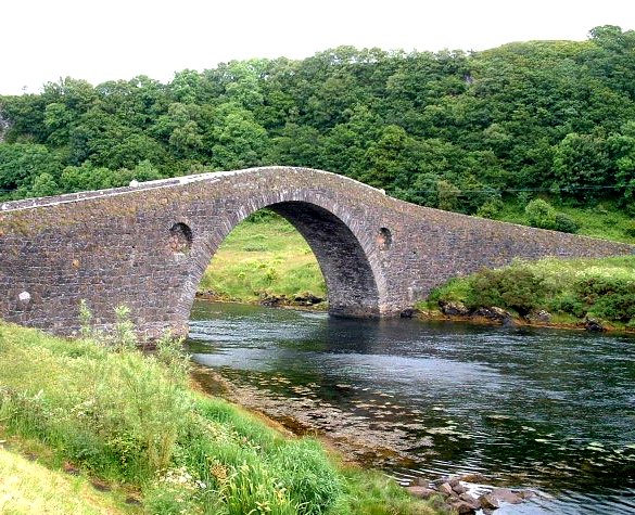
Clachan Bridge

The Clachan Bridge is a simple, single-arched, hump-backed, masonry bridge spanning the Clachan Sound, 13 kilometres (8 mi) southwest of Oban in Argyll...

Torsa

Torsa (occasionally Torsay) is one of the Slate Islands in Argyll and Bute, Scotland. Lying east of Luing and south of Seil, this tidal island was inhabited...

Slate Islands

The Slate Islands are an island group in the Inner Hebrides, lying immediately off the west coast of Scotland, north of Jura and southwest of Oban. The...

Nearby Amenities

Located within 500m of 56.290577,-5.615125
Kilbrandon War Memorial
Historic: memorial
Lat/Long: 56.2901046/-5.6158504
Passing Place
Lat/Long: 56.2871964/-5.6110582
Balvicar
Name En: Balvicar
Name Gd: Baile a' Bhiocair
Place: village
Wikidata: Q4853119
Wikipedia: en:Balvicar
Lat/Long: 56.2921666/-5.6135518
Post Office
Balvicar Post Office
Addr Postcode: PA34 4TE
Branch: Balvicar
Brand: Post Office
Brand Wikidata: Q1783168
Check Date: 2020-02-20
Contact Website: https://www.postoffice.co.uk/branch-finder/1058584/balvicar
Ref Pol Id: 1430
Source: survey
Lat/Long: 56.2921131/-5.613455
Post Box
Collection Times: Mo-Fr 12:00; Sa 09:45
Operator: Royal Mail
Post Box Manufacturer: Carron Company, Stirlingshire
Post Box Type: lamp
Ref: PA34 199
Royal Cypher: scottish_crown
Source: survey
Lat/Long: 56.2924729/-5.6136381
Entrance: main
Lat/Long: 56.2921378/-5.6135432
Bus Stop
Balvicar Stores
Naptan AtcoCode: 60707652
Naptan NaptanCode: 54728585
Lat/Long: 56.2922657/-5.614212
Seil
Bunker Type: ROC Underground Observation Post
Military: bunker
Lat/Long: 56.2916902/-5.6073925
Entrance: yes
Lat/Long: 56.2864153/-5.6131817
Passing Place
Lat/Long: 56.2873719/-5.6127268
Power: pole
Lat/Long: 56.2923186/-5.6132429
Power: pole
Lat/Long: 56.2925362/-5.6157939
Power: pole
Lat/Long: 56.2924649/-5.6188635
Power: pole
Lat/Long: 56.2924346/-5.6203143
Power: pole
Lat/Long: 56.2923887/-5.6219853
Power: pole
Lat/Long: 56.2923597/-5.6141187
Power: pole
Lat/Long: 56.2929714/-5.6132407
Power: pole
Lat/Long: 56.2935602/-5.6124042
Power: pole
Lat/Long: 56.2937838/-5.6126198
Power: pole
Lat/Long: 56.2910104/-5.6168483
Power: pole
Lat/Long: 56.2913792/-5.6165956
Power: pole
Lat/Long: 56.2919414/-5.6162122
Power: pole
Lat/Long: 56.2877472/-5.6096331
Power: pole
Lat/Long: 56.2882683/-5.6110905
Power: pole
Lat/Long: 56.2882103/-5.6126917
Power: pole
Lat/Long: 56.2881679/-5.6143953
Power: pole
Lat/Long: 56.2881002/-5.6159443
Power: pole
Lat/Long: 56.2880603/-5.6172383
Material: wood
Power: pole
Lat/Long: 56.2880277/-5.6180988
Power: pole
Lat/Long: 56.2879926/-5.6190116
Power: pole
Lat/Long: 56.2888366/-5.6103302
Power: pole
Lat/Long: 56.2894762/-5.6098009
Power: pole
Lat/Long: 56.2900335/-5.6093652
Power: pole
Lat/Long: 56.2906103/-5.6088663
Power: pole
Lat/Long: 56.2910951/-5.6084829
Power: pole
Lat/Long: 56.2913151/-5.6099708
Power: pole
Lat/Long: 56.2909452/-5.6094392
Power: pole
Lat/Long: 56.2905982/-5.6075461
Power: pole
Lat/Long: 56.2886564/-5.6185389
Power: pole
Lat/Long: 56.287376/-5.6194517
Power: pole
Lat/Long: 56.2873415/-5.617345
Material: wood
Power: pole
Lat/Long: 56.2869775/-5.618358
Power: pole
Lat/Long: 56.2943732/-5.6144912
Power: pole
Lat/Long: 56.2936587/-5.6149988
Power: pole
Lat/Long: 56.2931086/-5.6153866
Power: pole
Lat/Long: 56.2892765/-5.6180987
Power: pole
Lat/Long: 56.2898466/-5.6177079
Power: pole
Lat/Long: 56.2905728/-5.6171921
Give Way
Direction: backward
Lat/Long: 56.2910578/-5.6154547
Give Way
Direction: backward
Lat/Long: 56.2910261/-5.6153742
Power: pole
Lat/Long: 56.2924614/-5.6190303
Location Transition: yes
Power: pole
Lat/Long: 56.2918039/-5.6188497
Power: pole
Lat/Long: 56.2920882/-5.6208318
Power: pole
Lat/Long: 56.2916283/-5.6215078
Power: pole
Lat/Long: 56.2911162/-5.622299
Power: pole
Lat/Long: 56.2907738/-5.6228194
Historic: milestone
Inscription: Easdale P.O. 2 miles, Kilninver 6, Oban 14
Material: iron
Lat/Long: 56.2933784/-5.6126471
The data included in this document is from www.openstreetmap.org. The data is made available under ODbL.

Have you been to Balvicar?

Leave your review of Balvicar below (or comments, questions and feedback).