Lecket Hill

Hill, Mountain in Stirlingshire

Scotland

Lecket Hill

Crow Road nears its highest point The Crow Road, more formally known as the B822, climbs north over the Campsies from Lennoxtown. Just a few miles carry the traveller from the fringes of a big city to genuinely upland scenery. This photo looks south from more or less the highest point.
Crow Road nears its highest point Credit: Alec MacKinnon

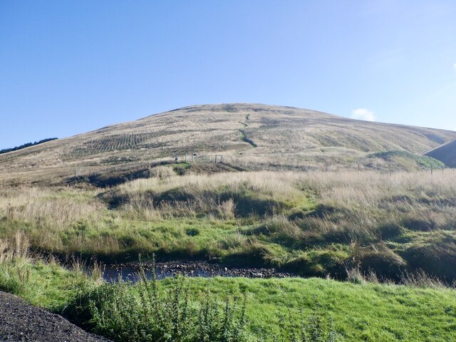
Lecket Hill is a prominent landmark located in Stirlingshire, Scotland. Rising to a height of 307 meters (1,007 feet), it is categorized as a hill rather than a mountain due to its relatively modest elevation. Situated near the town of Denny, Lecket Hill is part of the picturesque Ochil Hills range, which extends across central Scotland.

The hill offers stunning panoramic views of the surrounding landscape, including the Forth Valley to the south and the Campsie Fells to the west. On clear days, it is possible to see as far as the city of Glasgow, approximately 25 kilometers (15 miles) away. Many visitors are drawn to Lecket Hill for its outstanding natural beauty and the opportunity it provides for outdoor activities such as hiking, walking, and birdwatching.

The hill is covered in a mixture of grasses, heather, and some scattered trees, creating a diverse and appealing habitat for local wildlife. Bird species commonly spotted in the area include red kites, buzzards, and peregrine falcons. The surrounding woodlands are home to a variety of small mammals, including squirrels, rabbits, and deer.

Access to Lecket Hill is relatively straightforward, with a well-maintained path leading to the summit. The hill is a popular spot for locals and tourists alike, offering a peaceful and tranquil escape from the hustle and bustle of everyday life. Whether one seeks a challenging hike or a leisurely stroll, Lecket Hill provides a memorable experience for all who venture to its summit.

If you have any feedback on the listing, please let us know in the comments section below.

Lecket Hill Images

Images are sourced within 2km of 56.004244/-4.1751847 or Grid Reference NS6481. Thanks to Geograph Open Source API. All images are credited.

Crow Road nears its highest point The Crow Road, more formally known as the B822, climbs north over the Campsies from Lennoxtown. Just a few miles carry the traveller from the fringes of a big city to genuinely upland scenery. This photo looks south from more or less the highest point.
Crow Road nears its highest point
The Crow Road, more formally known as the B822, climbs north over the Campsies from Lennoxtown. Just a few miles carry the traveller from the fringes of a big city to genuinely upland scenery. This photo looks south from more or less the highest point.
Path up Lecket Hill Replaces the path shown on the Ordnance Survey 1:25,000 map. The hillside has been forested but there are good gates on either side of the plantation so no problems with the deer fences.
Path up Lecket Hill
Replaces the path shown on the Ordnance Survey 1:25,000 map. The hillside has been forested but there are good gates on either side of the plantation so no problems with the deer fences.
Young trees, Campsie Fells The hillside west of the Crow Road has been planted with trees.
Young trees, Campsie Fells
The hillside west of the Crow Road has been planted with trees.
Forest road exit, Moss Maigry Near the watershed on the Crow Road.
Forest road exit, Moss Maigry
Near the watershed on the Crow Road.
Nineteentimes Burn The Crow Road near the East-West Watershed.
Nineteentimes Burn
The Crow Road near the East-West Watershed.
Forest road beneath Lecket Hill
Clearfell and view A clear felled area on the north side of Lecket Hill with a view over hidden Fintry towards Stronend.
Clearfell and view
A clear felled area on the north side of Lecket Hill with a view over hidden Fintry towards Stronend.
Forest road, Lecket Hill
Forestry road and quarry Road building stone.
Forestry road and quarry
Road building stone.
Forest Road above Waterhead
Road end, Drove Hill From here it is possible to escape to open moorland by rides but there are a lot of windblown trees and patches of deep mud along the way.
Road end, Drove Hill
From here it is possible to escape to open moorland by rides but there are a lot of windblown trees and patches of deep mud along the way.
Lichen covered Sitka Spruce Taken during the somewhat stressful exit from the forest. (Deep mud and windthrow).
Lichen covered Sitka Spruce
Taken during the somewhat stressful exit from the forest. (Deep mud and windthrow).
Ride, Drove Hill Used to escape the forest. Deep mud and fallen trees kept getting in the way though.
Ride, Drove Hill
Used to escape the forest. Deep mud and fallen trees kept getting in the way though.
Forested slopes of Meike Bin
North side of Lecket Hill
Meikle Bin View from the north side of Lecket Hill.
Meikle Bin
View from the north side of Lecket Hill.
East side of Lecket Hill Rough grassland around Boyd's Burn.
East side of Lecket Hill
Rough grassland around Boyd's Burn.
Moorland on Lecket Hill A broad ridge above Boyd's Burn with Meikle Bin beyond.
Moorland on Lecket Hill
A broad ridge above Boyd's Burn with Meikle Bin beyond.
Show me another place!

Lecket Hill is located at Grid Ref: NS6481 (Lat: 56.004244, Lng: -4.1751847)

Unitary Authority: East Dunbartonshire

Police Authority: Greater Glasgow

What 3 Words

///absorb.acting.drill. Near Lennoxtown, East Dunbartonshire

Nearby Locations

Lecket Hill

Related Wikis

Meikle Bin

Meikle Bin is a peak in the Campsie Fells in Central Scotland. It is the second-highest of the group at 570 metres (1,870 ft), and with its prominence...

Glorat

Glorat is a place and estate in the parish of Campsie in East Dunbartonshire, Scotland. == History == A towerhouse was built at Glorat in the 16th century...

Glorat House

Glorat House is a 19th-century mansion house in East Dunbartonshire, Scotland. It is located in Milton of Campsie, in the former county of Stirlingshire...

Peggie's Spout

Peggie's Spout is a waterfall of Scotland. == See also == Waterfalls of Scotland == References ==

Nearby Amenities

Located within 500m of 56.004244,-4.1751847
Lecket Hill
Corbett: no
Donald: no
Ele: 547
Graham: no
Man Made: cairn
Munro: no
Natural: peak
Note: small cairn
Source: npe
Lat/Long: 56.0042433/-4.1753898
The data included in this document is from www.openstreetmap.org. The data is made available under ODbL.

Have you been to Lecket Hill?

Leave your review of Lecket Hill below (or comments, questions and feedback).