Baltilly

Settlement in Fife

Scotland

Baltilly

The Moor Road The path over Ceres Moor heading towards Cupar from Ceres.
The Moor Road Credit: Scott Cormie

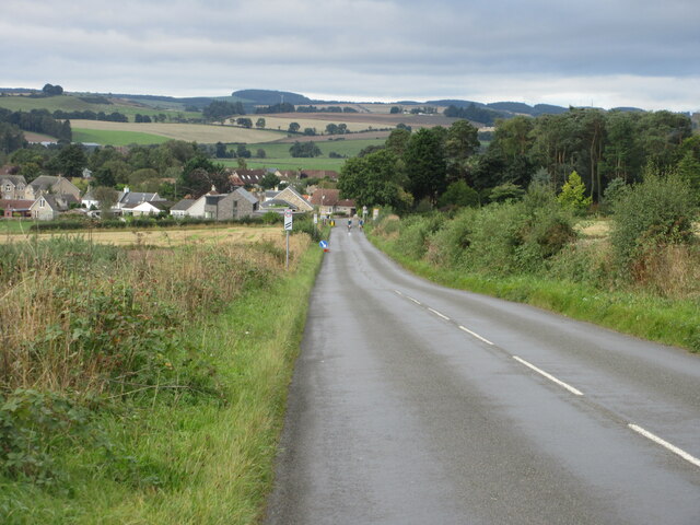
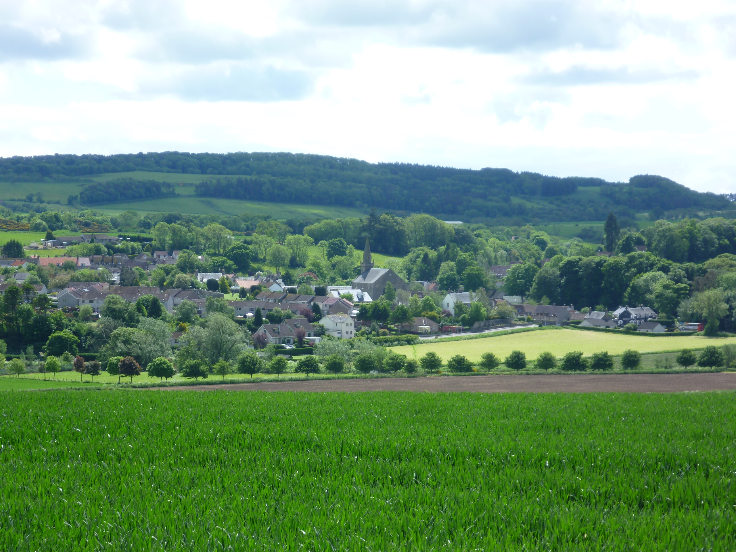
Baltilly is a small village located in the county of Fife, Scotland. Situated approximately 4 miles south-west of Cupar, it lies in a picturesque rural setting, surrounded by rolling hills and fertile farmland. The village is positioned near the A914 road, providing convenient access to nearby towns and cities.

Historically, Baltilly was a farming community, with agriculture being the primary source of income for its inhabitants. Today, the village still retains its rural charm, with several traditional farmhouses and cottages dotting the landscape.

Despite its small size, Baltilly boasts a strong sense of community spirit. The village has a close-knit population, and residents often come together to organize various social events and activities. The local primary school plays a central role in the community, serving as an important hub for families in the area.

For amenities, Baltilly has limited facilities within the village itself. However, the nearby town of Cupar provides a wider range of services, including shops, supermarkets, healthcare facilities, and recreational activities.

The surrounding area offers plenty of opportunities for outdoor pursuits, with numerous walking trails and cycling routes crisscrossing the beautiful countryside. Additionally, Baltilly is within a short drive of the stunning coastline of the East Neuk of Fife, renowned for its picturesque fishing villages and sandy beaches.

Overall, Baltilly is a charming village that provides a tranquil and idyllic living environment, perfectly suited for those seeking a peaceful rural lifestyle with easy access to nearby amenities.

If you have any feedback on the listing, please let us know in the comments section below.

Baltilly Images

Images are sourced within 2km of 56.287512/-2.9869787 or Grid Reference NO3911. Thanks to Geograph Open Source API. All images are credited.

The Moor Road The path over Ceres Moor heading towards Cupar from Ceres.
The Moor Road
The path over Ceres Moor heading towards Cupar from Ceres.
C8 (Fife) Road towards Ceres The C8 road heading down the hill south-westwards towards Ceres.
C8 (Fife) Road towards Ceres
The C8 road heading down the hill south-westwards towards Ceres.
Stubble, Chance Inn
Stubble, Chance Inn
Annotated benchmark, Woodburne Stables, Ceres Beautifully annotated cut benchmark, described on database at <span class="nowrap"><a title="https://www.bench-marks.org.uk/bm148058" rel="nofollow ugc noopener" href="https://www.bench-marks.org.uk/bm148058">Link</a><img style="margin-left:2px;" alt="External link" title="External link - shift click to open in new window" src="https://s1.geograph.org.uk/img/external.png" width="10" height="10"/></span>.
Annotated benchmark, Woodburne Stables, Ceres
Beautifully annotated cut benchmark, described on database at LinkExternal link.
The tattered remains of NCN1 I dont tag the National Cycle Network anymore since Sustrans dismantled large chunks of it making the signage confusing and actually spending money covering up the numbers and erecting silly signs like this. The route is of course still there but only promoted as a lot of fragments scattered over the land.

The road that they are worried about is quiet. (There is a short bit of A916 first)
The tattered remains of NCN1
I dont tag the National Cycle Network anymore since Sustrans dismantled large chunks of it making the signage confusing and actually spending money covering up the numbers and erecting silly signs like this. The route is of course still there but only promoted as a lot of fragments scattered over the land. The road that they are worried about is quiet. (There is a short bit of A916 first)
Benchmark, Chance Inn Ordnance Survey benchmark, described on database at <span class="nowrap"><a title="https://www.bench-marks.org.uk/bm163965" rel="nofollow ugc noopener" href="https://www.bench-marks.org.uk/bm163965">Link</a><img style="margin-left:2px;" alt="External link" title="External link - shift click to open in new window" src="https://s1.geograph.org.uk/img/external.png" width="10" height="10"/></span>. For context photo, see <a href="https://www.geograph.org.uk/photo/7462703">NO3710 : Wall, Chance Inn</a>.
Benchmark, Chance Inn
Ordnance Survey benchmark, described on database at LinkExternal link. For context photo, see NO3710 : Wall, Chance Inn.
Scotstarvit Tower
Scotstarvit Tower
Scotstarvit Tower and Cottage from the south
Wall, Chance Inn There is an Ordnance Survey benchmark on this wall. See <a href="https://www.geograph.org.uk/photo/7430123">NO3710 : Benchmark, Chance Inn</a>
Wall, Chance Inn
There is an Ordnance Survey benchmark on this wall. See NO3710 : Benchmark, Chance Inn
Field at Curling Pond Road A rather large field, just north of Curling Pond Road at the outskirts of Ceres. Curling Pond Road leads to, surprise, the Curling Pond, then continues and ends at a wastewater treatment plant.
Field at Curling Pond Road
A rather large field, just north of Curling Pond Road at the outskirts of Ceres. Curling Pond Road leads to, surprise, the Curling Pond, then continues and ends at a wastewater treatment plant.
Cedar tree In the grounds of Hill of Tarvit Mansion House near Cupar is this specimen of 'Cedrus atlantica', the Atlas Cedar. This tree has a slight blue tinge (known as the 'glaucous' form) indicating that it is one of the cultivated varieties. This species is native to Morocco and Algeria.
See also: <a title="https://www.geograph.org.uk/article/Hill-of-Tarvit-Mansion-House-Gardens" href="https://www.geograph.org.uk/article/Hill-of-Tarvit-Mansion-House-Gardens">Link</a>
Cedar tree
In the grounds of Hill of Tarvit Mansion House near Cupar is this specimen of 'Cedrus atlantica', the Atlas Cedar. This tree has a slight blue tinge (known as the 'glaucous' form) indicating that it is one of the cultivated varieties. This species is native to Morocco and Algeria. See also: Link
The Provost, Ceres A Category B listed <span class="nowrap"><a title="http://portal.historicenvironment.scot/designation/LB4291" rel="nofollow ugc noopener" href="http://portal.historicenvironment.scot/designation/LB4291">Link</a><img style="margin-left:2px;" alt="External link" title="External link - shift click to open in new window" src="https://s1.geograph.org.uk/img/external.png" width="10" height="10"/></span> toby jug figure. According to Canmore <span class="nowrap"><a title="https://canmore.org.uk/site/97951/ceres-high-street-the-provost" rel="nofollow ugc noopener" href="https://canmore.org.uk/site/97951/ceres-high-street-the-provost">Link</a><img style="margin-left:2px;" alt="External link" title="External link - shift click to open in new window" src="https://s1.geograph.org.uk/img/external.png" width="10" height="10"/></span> it 'was originally located in the churchyard grounds with a 17th century fireplace with frieze as its base. Later it became separated from its base but they were reunited in June 1939 in the gable of a garage in High Street, Ceres.' The figure represents the Rev. Thomas Buchanan, a minister in the village kirk and last provost of Ceres.
The Provost, Ceres
A Category B listed LinkExternal link toby jug figure. According to Canmore LinkExternal link it 'was originally located in the churchyard grounds with a 17th century fireplace with frieze as its base. Later it became separated from its base but they were reunited in June 1939 in the gable of a garage in High Street, Ceres.' The figure represents the Rev. Thomas Buchanan, a minister in the village kirk and last provost of Ceres.
Hill of Tarvit mansion house This house near Cupar in Fife is owned by the National Trust for Scotland
Hill of Tarvit mansion house
This house near Cupar in Fife is owned by the National Trust for Scotland
Monument at Hill of Tarvit This monument stands on top of the Hill of Tarvit. The mansion house is just to the south. Fine views all over East Fife can be enjoyed up here.
Monument at Hill of Tarvit
This monument stands on top of the Hill of Tarvit. The mansion house is just to the south. Fine views all over East Fife can be enjoyed up here.
Ceres village from the West From where the B939 Craigrothie to St Andrews Road enters the village. The road out to the right leads to Teassesmill and on to Largo.
Ceres village from the West
From where the B939 Craigrothie to St Andrews Road enters the village. The road out to the right leads to Teassesmill and on to Largo.
Scotstarvit Tower. A mediaeval Scottish tower house, with Hill of Tarvit to its right.
Scotstarvit Tower.
A mediaeval Scottish tower house, with Hill of Tarvit to its right.
Craigrothie Showing the Kingarroch Inn, right foreground, and the village street, which is part of the A916
Craigrothie
Showing the Kingarroch Inn, right foreground, and the village street, which is part of the A916
Barbarafield Farm
Barbarafield Farm
Show me another place!

Baltilly is located at Grid Ref: NO3911 (Lat: 56.287512, Lng: -2.9869787)

Unitary Authority: Fife

Police Authority: Fife

What 3 Words

///ruler.unspoiled.horns. Near Cupar, Fife

Nearby Locations

Bridgend Baltilly

Related Wikis

Ceres, Fife

Ceres is a village in Fife, Scotland, located in a small glen approximately 2 miles (3 km) over the Ceres Moor from Cupar and 7 mi (11 km) from St Andrews...

Hill of Tarvit

The Hill of Tarvit is a 20th-century mansion house and gardens in Fife, Scotland. They were designed by Sir Robert Lorimer and are today owned by the National...

Craighall Castle

Craighall Castle is located in Ceres, Fife, Scotland. It was built in 1637 by Sir Thomas Hope but there was a tower of previous land owners before 1637...

Scotstarvit Tower

Scotstarvit Tower is a tower house in Fife, Scotland. It is situated 2 miles (3.2 km) south of Cupar, between Tarvit Hill and Walton Hill, south of the...

Nearby Amenities

Located within 500m of 56.287512,-2.9869787
Power: pole
Lat/Long: 56.2911231/-2.9870718
Power: pole
Lat/Long: 56.290231/-2.9837051
Power: pole
Lat/Long: 56.2918365/-2.9879948
Power: pole
Lat/Long: 56.2906359/-2.985254
Power: pole
Lat/Long: 56.2898216/-2.9821209
Power: pole
Lat/Long: 56.2893728/-2.9804328
Power: pole
Lat/Long: 56.2843302/-2.9896808
Power: pole
Lat/Long: 56.2847663/-2.9896244
Power: pole
Lat/Long: 56.2851682/-2.9895766
Power: pole
Lat/Long: 56.285372/-2.9895151
Power: pole
Lat/Long: 56.2898857/-2.9868271
Power: pole
Lat/Long: 56.2896649/-2.9880515
Power: pole
Lat/Long: 56.2894175/-2.989329
Power: pole
Lat/Long: 56.289191/-2.9905961
Power: pole
Lat/Long: 56.2889493/-2.9918462
Power: pole
Lat/Long: 56.2886365/-2.9928214
Power: pole
Lat/Long: 56.2883512/-2.9936975
Power: pole
Lat/Long: 56.2877465/-2.9932791
Power: pole
Lat/Long: 56.2873645/-2.9930041
Power: pole
Lat/Long: 56.2868564/-2.9926472
Power: pole
Lat/Long: 56.2863569/-2.9919197
Power: pole
Lat/Long: 56.2859114/-2.9912724
Power: pole
Lat/Long: 56.2854421/-2.9905568
Power: pole
Lat/Long: 56.2853786/-2.988972
Power: pole
Lat/Long: 56.2853692/-2.9883948
Power: pole
Lat/Long: 56.2852241/-2.9878586
Power: pole
Lat/Long: 56.28508/-2.9873086
Power: pole
Lat/Long: 56.2849644/-2.9868356
Power: pole
Lat/Long: 56.2850014/-2.9904971
Power: pole
Lat/Long: 56.2845757/-2.9904373
Power: pole
Lat/Long: 56.2841226/-2.9903775
The data included in this document is from www.openstreetmap.org. The data is made available under ODbL.

Have you been to Baltilly?

Leave your review of Baltilly below (or comments, questions and feedback).