Cnoc Blàr na Curaich

Hill, Mountain in Sutherland

Scotland

Cnoc Blàr na Curaich

Ausdale The remote settlement is to the west of L.Buidhe on the dead-end road to Craigton
Ausdale Credit: Mick Crawley

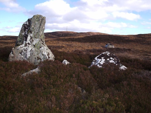
Cnoc Blàr na Curaich is a hill located in the remote and rugged landscape of Sutherland, in the Scottish Highlands. Standing at an elevation of 543 meters (1781 feet), it offers stunning panoramic views of the surrounding area, including the nearby Loch Shin and Ben Klibreck mountain.

The hill is characterized by its rocky terrain and heather-covered slopes, making it a challenging but rewarding hike for outdoor enthusiasts. The ascent to the summit is steep in places, but there are well-defined paths that guide hikers to the top.

Cnoc Blàr na Curaich is home to a variety of wildlife, including red deer, golden eagles, and ptarmigan, making it a popular spot for birdwatching and wildlife enthusiasts. The hill is also steeped in history, with ancient ruins and stone circles scattered throughout the area, providing a glimpse into the rich cultural heritage of the region.

Overall, Cnoc Blàr na Curaich offers a unique and memorable outdoor experience for those looking to explore the untamed beauty of the Scottish Highlands.

If you have any feedback on the listing, please let us know in the comments section below.

Cnoc Blàr na Curaich Images

Images are sourced within 2km of 57.935092/-4.3432306 or Grid Reference NH6196. Thanks to Geograph Open Source API. All images are credited.

Ausdale The remote settlement is to the west of L.Buidhe on the dead-end road to Craigton
Ausdale
The remote settlement is to the west of L.Buidhe on the dead-end road to Craigton
Wet heath at Lydsurach Cotton grass bog north of Bonar Bridge. The phone mast in the distance is on Cnoc a' Choire Bhuidhe (298 m).
Wet heath at Lydsurach
Cotton grass bog north of Bonar Bridge. The phone mast in the distance is on Cnoc a' Choire Bhuidhe (298 m).
Ausdale ruin
Ausdale ruin
Remains of an old walled field enclosure at Claisnafaire
Allt Loch Laro at Claisnafaire
Clump of trees near Craigton
Ausdale Cottage Taken from the roadside, a crofting area
Ausdale Cottage
Taken from the roadside, a crofting area
Craigton Croft house This is the end of the road, and so peaceful.
Craigton Croft house
This is the end of the road, and so peaceful.
The road out of Craigton Croft holding With the Allt Asdale burn to my left and the hill Cnoc Blar na Curaich away in the distance.
The road out of Craigton Croft holding
With the Allt Asdale burn to my left and the hill Cnoc Blar na Curaich away in the distance.
Looking Towards Coir 'an t-Seilich Mor From the forestry Road. I bet all the Deer come out here to graze at night.
Looking Towards Coir 'an t-Seilich Mor
From the forestry Road. I bet all the Deer come out here to graze at night.
Looking Towards Coir 'an t-Seilich Mor From just past the forestry road end.
Looking Towards Coir 'an t-Seilich Mor
From just past the forestry road end.
Mobile Phone Mast on Cnoc a Choire Bhuidhe Taken just off the dirt road that leads to the mast.
Mobile Phone Mast on Cnoc a Choire Bhuidhe
Taken just off the dirt road that leads to the mast.
Looking Towards Ardgay and Loch migdale From near Garbh Leathad.
Looking Towards Ardgay and Loch migdale
From near Garbh Leathad.
Telecommunications Mast on Sidhean Mor Looking at from the forestry Road  In Balblair Woods.
Telecommunications Mast on Sidhean Mor
Looking at from the forestry Road In Balblair Woods.
Looking East towards Cnoc a' Choire Bhuidhe With a telecommunications mast at the top of it.
Looking East towards Cnoc a' Choire Bhuidhe
With a telecommunications mast at the top of it.
Looking North to NH 61463 95352 Geothermal Heating Drilling
Looking North to NH 61463 95352
Geothermal Heating Drilling
Not the Hampton Court Maze It was much too nice for that.... and I was all alone. Not in a sad way I hasten to add.
Not the Hampton Court Maze
It was much too nice for that.... and I was all alone. Not in a sad way I hasten to add.
Soft going = Hard going Marked as a track, and in drier conditions it may well revert to one. I suspect that most of the time it is as I found it today: a quagmire. Away from the track it was just as bad.
Soft going = Hard going
Marked as a track, and in drier conditions it may well revert to one. I suspect that most of the time it is as I found it today: a quagmire. Away from the track it was just as bad.
Show me another place!

Cnoc Blàr na Curaich is located at Grid Ref: NH6196 (Lat: 57.935092, Lng: -4.3432306)

Unitary Authority: Highland

Police Authority: Highlands and Islands

What 3 Words

///trailers.scornful.club. Near Lairg, Highland

Nearby Locations

Cnoc Blàr na Curaich

Related Wikis

Invershin railway station

Invershin railway station is a railway station in the Highland council area of Scotland. The station is on the Far North Line, 61 miles 34 chains (98.9...

Kyle of Sutherland

The Kyle of Sutherland (Scottish Gaelic: An Caol Catach) is a river estuary that separates Sutherland from Ross-shire. It flows into the Dornoch Firth...

Invershin

Invershin (Scottish Gaelic: Inbhir Sin) is a scattered village in the Parish of Creich, 6 miles (10 km) south of Lairg and 4 miles (6.4 km) north of Bonar...

Migdale Hoard

The Migdale Hoard is a group of early Bronze Age jewellery discovered by workmen blasting a granite knoll behind Bonar Bridge, Scotland, near what is known...

Nearby Amenities

Located within 500m of 57.935092,-4.3432306
Cnoc Blar na Curaich
Place: locality
Source: OD Streetview
Lat/Long: 57.9360762/-4.3440839
The data included in this document is from www.openstreetmap.org. The data is made available under ODbL.

Have you been to Cnoc Blàr na Curaich?

Leave your review of Cnoc Blàr na Curaich below (or comments, questions and feedback).