Bargeny Hill

Hill, Mountain in Stirlingshire

Scotland

Bargeny Hill

Torrance, Lennoxtown and the Campsie Fells from the air Torrance is at the bottom of the photo and Lennoxtown can be seen nestling at the foot of the Campsie Fells. The Crow Road can just be seen to the left of Lennoxtown. A wind farm is prominent on the horizon, with another less prominent wind farm is on the left horizon in the far distance.

Viewed from a flight from a thundery Gatwick <a href="https://www.geograph.org.uk/photo/2482228">TQ2640 : Thunderstorm over Gatwick Airport from the air</a> to Glasgow.
Torrance, Lennoxtown and the Campsie Fells from the air Credit: Thomas Nugent

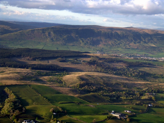
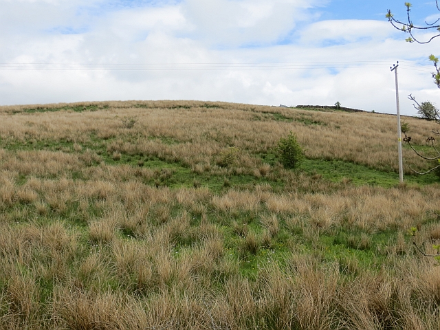
Bargeny Hill, located in Stirlingshire, Scotland, is a prominent hill standing at an elevation of 834 feet (254 meters). Situated in the heart of the Ayrshire Hills, Bargeny Hill offers stunning panoramic views of the surrounding countryside. It is part of the larger Galloway Hills, a range known for its diverse wildlife and picturesque landscapes.

The hill is primarily composed of sedimentary rocks, including sandstone and limestone, which have been shaped by glaciation over thousands of years. Its steep slopes and rugged terrain make it a popular destination for hikers and outdoor enthusiasts looking for a challenging climb.

Bargeny Hill is home to a variety of plant and animal species, including heather, gorse, and various woodland creatures. Birdwatchers can often spot raptors like buzzards and kestrels soaring above the hill. The area is also known for its rich history, with evidence of ancient settlements and burial mounds dating back to the Bronze Age.

Access to Bargeny Hill is relatively straightforward, with several paths and trails leading to the summit. The hill offers a range of activities, including hiking, wildlife spotting, and photography. It is an ideal destination for those seeking a peaceful retreat in nature, away from the hustle and bustle of city life.

Overall, Bargeny Hill is a picturesque and historically significant landmark in Stirlingshire, offering visitors a chance to explore Scotland's natural beauty and immerse themselves in its rich cultural heritage.

If you have any feedback on the listing, please let us know in the comments section below.

Bargeny Hill Images

Images are sourced within 2km of 55.940904/-4.229424 or Grid Reference NS6074. Thanks to Geograph Open Source API. All images are credited.

Torrance, Lennoxtown and the Campsie Fells from the air Torrance is at the bottom of the photo and Lennoxtown can be seen nestling at the foot of the Campsie Fells. The Crow Road can just be seen to the left of Lennoxtown. A wind farm is prominent on the horizon, with another less prominent wind farm is on the left horizon in the far distance.

Viewed from a flight from a thundery Gatwick <a href="https://www.geograph.org.uk/photo/2482228">TQ2640 : Thunderstorm over Gatwick Airport from the air</a> to Glasgow.
Torrance, Lennoxtown and the Campsie Fells from the air
Torrance is at the bottom of the photo and Lennoxtown can be seen nestling at the foot of the Campsie Fells. The Crow Road can just be seen to the left of Lennoxtown. A wind farm is prominent on the horizon, with another less prominent wind farm is on the left horizon in the far distance. Viewed from a flight from a thundery Gatwick TQ2640 : Thunderstorm over Gatwick Airport from the air to Glasgow.
Torrance from the air The River Kelvin can be seen meandering under Torrance Bridge in the foreground. Viewed from a Glasgow bound flight from Luton.
Torrance from the air
The River Kelvin can be seen meandering under Torrance Bridge in the foreground. Viewed from a Glasgow bound flight from Luton.
Balmore water works from the air The recently upgraded works to the north of Glasgow. Viewed from a Glasgow bound flight from Luton.
Balmore water works from the air
The recently upgraded works to the north of Glasgow. Viewed from a Glasgow bound flight from Luton.
The Campsie Fells from the air The farms in the foreground are Easter Blairskaith and Castlehill on Tower Road. Viewed from a Glasgow bound flight from Luton.
The Campsie Fells from the air
The farms in the foreground are Easter Blairskaith and Castlehill on Tower Road. Viewed from a Glasgow bound flight from Luton.
Forth and Clyde Canal The towpath is a popular cycle path.
Forth and Clyde Canal
The towpath is a popular cycle path.
Forth and Clyde Canal View westwards towards Hungryside Bridge.
Forth and Clyde Canal
View westwards towards Hungryside Bridge.
Queensview An old road alignment in Torrance, now incorporated into a residential street.
Queensview
An old road alignment in Torrance, now incorporated into a residential street.
Queensview, Torrance
Holstein heifers Grassland between Torrance and Balmore.
Holstein heifers
Grassland between Torrance and Balmore.
Waterworks, Balmore A very large water treatment works, presumably serving Glasgow. Part of the site was once occupied by a colliery.
Waterworks, Balmore
A very large water treatment works, presumably serving Glasgow. Part of the site was once occupied by a colliery.
A807, Balmore Approaching the village, the water works are off shot to the right.
A807, Balmore
Approaching the village, the water works are off shot to the right.
Playground, Croft Road Park in a loop of Croft Road.
Playground, Croft Road
Park in a loop of Croft Road.
Back o' Waterworks Usual dumper attack on a back road.
Back o' Waterworks
Usual dumper attack on a back road.
Damp  pasture, Barraston
Damp pasture, Barraston
Quarry, Barraston Mapped as a clay quarry but older maps suggest that limestone and coal was extracted here as well as fire clay. Now flooded.
Quarry, Barraston
Mapped as a clay quarry but older maps suggest that limestone and coal was extracted here as well as fire clay. Now flooded.
Damp  pasture, Barraston Above Barraston Road.
Damp pasture, Barraston
Above Barraston Road.
Across the Shaw Burn Farmland near Bargrochan
Across the Shaw Burn
Farmland near Bargrochan
Acre Valley Road Northern edge of Torrance.
Acre Valley Road
Northern edge of Torrance.
Show me another place!

Bargeny Hill is located at Grid Ref: NS6074 (Lat: 55.940904, Lng: -4.229424)

Unitary Authority: East Dunbartonshire

Police Authority: Greater Glasgow

What 3 Words

///treat.dance.grant. Near Torrance, East Dunbartonshire

Nearby Locations

Bargeny Hill

Related Wikis

Balmore

Balmore (from the Scottish Gaelic "Baile Mòr" meaning a large settlement) is a small village formerly in the county of Stirlingshire, but now lies in East...

Balmore railway station

Balmore railway station was opened in 1879 on the Kelvin Valley Railway and served the coal mining area, farms and the village of Balmore in East Dunbartonshire...

Torrance railway station

Torrance railway station was opened in 1879 on the Kelvin Valley Railway and served the area of the village of Torrance in East Dunbartonshire until 1951...

East Dunbartonshire

East Dunbartonshire (Scots: Aest Dunbartanshire; Scottish Gaelic: Siorrachd Dhùn Bhreatann an Ear, pronounced [ˈʃirˠəxk ɣum ˈpɾʲɛht̪ən̪ˠ əɲ ˈɛɾ]) is one...

Nearby Amenities

Located within 500m of 55.940904,-4.229424
Bargeny Hill
Ele: 75
Natural: peak
Lat/Long: 55.9408768/-4.2296283
Power: tower
Lat/Long: 55.9433938/-4.2270422
Power: tower
Lat/Long: 55.9403959/-4.2275594
Power: tower
Lat/Long: 55.9369588/-4.2281945
Barrier: kissing_gate
Foot: yes
Lat/Long: 55.9408284/-4.2246539
Ford: yes
Lat/Long: 55.9412088/-4.2231867
Power: pole
Lat/Long: 55.9417049/-4.2319756
Power: pole
Lat/Long: 55.9423101/-4.2323426
Power: pole
Lat/Long: 55.9429957/-4.2327819
Power: pole
Lat/Long: 55.943542/-4.2331388
Power: pole
Lat/Long: 55.9440618/-4.2334506
The data included in this document is from www.openstreetmap.org. The data is made available under ODbL.

Have you been to Bargeny Hill?

Leave your review of Bargeny Hill below (or comments, questions and feedback).