Beardown Tors

Hill, Mountain in Devon West Devon

England

Beardown Tors

Cist and Capstone near Crow Tor (Scale 1m) <span class="nowrap"><a title="https://historicengland.org.uk/listing/the-list/list-entry/1016922?section=official-listing" rel="nofollow ugc noopener" href="https://historicengland.org.uk/listing/the-list/list-entry/1016922?section=official-listing">Link</a><img style="margin-left:2px;" alt="External link" title="External link - shift click to open in new window" src="https://s1.geograph.org.uk/img/external.png" width="10" height="10"/></span>
Cist and Capstone near Crow Tor Credit: Sandy Gerrard

Beardown Tors is a prominent hill located in the Dartmoor National Park, in the county of Devon, England. Situated approximately 2 miles north of the village of Princetown, it stands at an elevation of around 1,500 feet (457 meters) above sea level. Beardown Tors is classified as a tor, which refers to a rocky outcrop commonly found in Dartmoor.

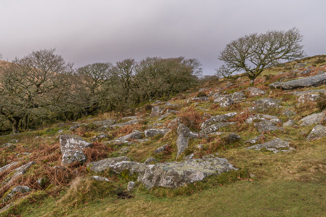
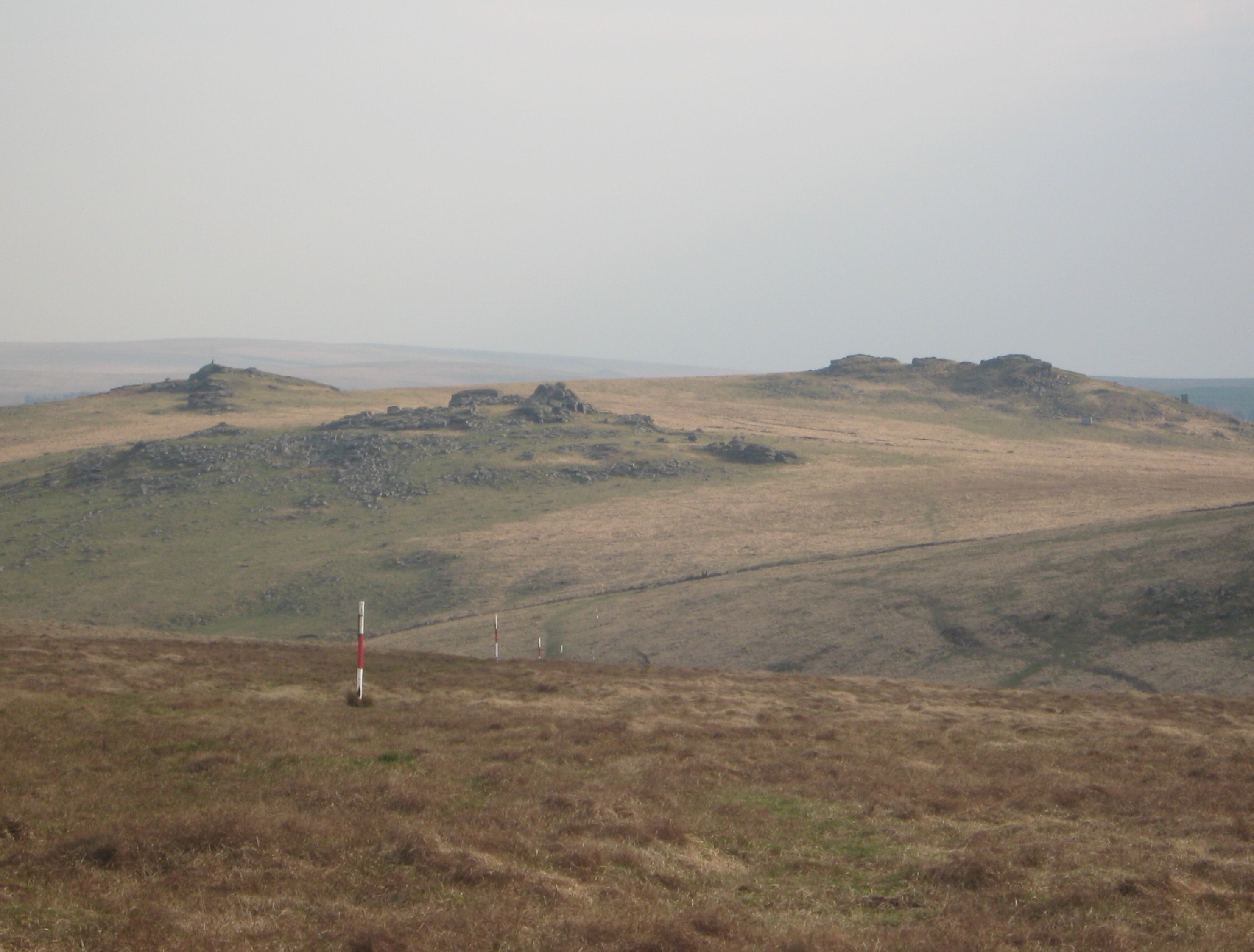
The hill is characterized by its rugged and craggy appearance, with large granite rocks scattered across its slopes. These unique rock formations have been shaped by centuries of weathering and erosion, resulting in an impressive landscape. The tors provide an excellent vantage point, offering panoramic views of the surrounding countryside, including the nearby tors of Great Mis Tor and Cramber Tor.

Beardown Tors is a popular destination for hikers and outdoor enthusiasts, attracting visitors who enjoy walking, climbing, and exploring the Dartmoor wilderness. Several footpaths and trails lead to the summit, providing various routes for different levels of difficulty.

The hill is also known for its rich wildlife and natural habitats. It is home to a variety of plant species, including heather, gorse, and bilberry, which thrive in the moorland environment. Additionally, Beardown Tors supports a diverse range of birdlife, such as buzzards and peregrine falcons, as well as small mammals like rabbits and voles.

In summary, Beardown Tors in Devon is a striking hill within Dartmoor National Park, offering stunning views, challenging hiking opportunities, and a diverse array of flora and fauna.

If you have any feedback on the listing, please let us know in the comments section below.

Beardown Tors Images

Images are sourced within 2km of 50.579112/-3.97529 or Grid Reference SX6077. Thanks to Geograph Open Source API. All images are credited.

Cist and Capstone near Crow Tor (Scale 1m) <span class="nowrap"><a title="https://historicengland.org.uk/listing/the-list/list-entry/1016922?section=official-listing" rel="nofollow ugc noopener" href="https://historicengland.org.uk/listing/the-list/list-entry/1016922?section=official-listing">Link</a><img style="margin-left:2px;" alt="External link" title="External link - shift click to open in new window" src="https://s1.geograph.org.uk/img/external.png" width="10" height="10"/></span>
Cist and Capstone near Crow Tor
(Scale 1m) LinkExternal link
Cairn and cist near Crow Tor (Scale 1m) <span class="nowrap"><a title="https://historicengland.org.uk/listing/the-list/list-entry/1016922?section=official-listing" rel="nofollow ugc noopener" href="https://historicengland.org.uk/listing/the-list/list-entry/1016922?section=official-listing">Link</a><img style="margin-left:2px;" alt="External link" title="External link - shift click to open in new window" src="https://s1.geograph.org.uk/img/external.png" width="10" height="10"/></span>
Cairn and cist near Crow Tor
(Scale 1m) LinkExternal link
West Dart valley Valley of the West Dart River above Two Bridges.  In the right background is Wistman's Wood.  On the left-hand hillside is the line of the Devonport Leat, a channel built in the 1790s to carry freshwater to Plymouth.
West Dart valley
Valley of the West Dart River above Two Bridges. In the right background is Wistman's Wood. On the left-hand hillside is the line of the Devonport Leat, a channel built in the 1790s to carry freshwater to Plymouth.
Wistman's Wood A small group of trees at the southern end of Wistman's Wood.  Across the hillside in the background can be seen the line of the Devonport Leat, a channel built in the 1790s to carry freshwater to Plymouth.
Wistman's Wood
A small group of trees at the southern end of Wistman's Wood. Across the hillside in the background can be seen the line of the Devonport Leat, a channel built in the 1790s to carry freshwater to Plymouth.
Wistman's Wood The southern edge of Wistman's Wood, with boulders covering the foreground.
Wistman's Wood
The southern edge of Wistman's Wood, with boulders covering the foreground.
Wistman's Wood The southern edge of Wistman's Wood, with boulders covering the foreground.
Wistman's Wood
The southern edge of Wistman's Wood, with boulders covering the foreground.
Wistman's Wood The southern edge of Wistman's Wood.  Across the hillside in the background can be seen the line of the Devonport Leat, a channel built in the 1790s to carry freshwater to Plymouth.
Wistman's Wood
The southern edge of Wistman's Wood. Across the hillside in the background can be seen the line of the Devonport Leat, a channel built in the 1790s to carry freshwater to Plymouth.
Wistman's Wood Looking down the valley of the West Dart, with part of Wistman's Wood on the right.  Across the hillside in the background can be seen the line of the Devonport Leat, a channel built in the 1790s to carry freshwater to Plymouth.
Wistman's Wood
Looking down the valley of the West Dart, with part of Wistman's Wood on the right. Across the hillside in the background can be seen the line of the Devonport Leat, a channel built in the 1790s to carry freshwater to Plymouth.
Wistman's Wood A tree on the eastern edge of Wistman's Wood.
Wistman's Wood
A tree on the eastern edge of Wistman's Wood.
Wistman's Wood Lichen and moss on the branch of a tree in Wistman's Wood.
Wistman's Wood
Lichen and moss on the branch of a tree in Wistman's Wood.
Wistman's Wood Lichen, moss and ferns on a tree in Wistman's Wood.
Wistman's Wood
Lichen, moss and ferns on a tree in Wistman's Wood.
Wistman's Wood Lichen, moss and ferns on a tree in Wistman's Wood with moss-covered boulders below.
Wistman's Wood
Lichen, moss and ferns on a tree in Wistman's Wood with moss-covered boulders below.
Wistman's Wood Lichen on a twig on a tree in Wistman's Wood with moss-covered boulders in the background.
Wistman's Wood
Lichen on a twig on a tree in Wistman's Wood with moss-covered boulders in the background.
Wistman's Wood Lichen covering the twigs of a tree in Wistman's Wood with moss-covered boulders in the background.
Wistman's Wood
Lichen covering the twigs of a tree in Wistman's Wood with moss-covered boulders in the background.
Wistman's Wood Lichen covered tree in Wistman's Wood with moss-covered boulders below.  Across the hillside in the background can be seen the line of the Devonport Leat, a channel built in the 1790s to carry freshwater to Plymouth.
Wistman's Wood
Lichen covered tree in Wistman's Wood with moss-covered boulders below. Across the hillside in the background can be seen the line of the Devonport Leat, a channel built in the 1790s to carry freshwater to Plymouth.
Wistman's Wood Lichen and ferns on a tree in Wistman's Wood with moss-covered boulders below.
Wistman's Wood
Lichen and ferns on a tree in Wistman's Wood with moss-covered boulders below.
Wistman's Wood Lichen, moss and ferns on a tree in Wistman's Wood with moss-covered boulders below.
Wistman's Wood
Lichen, moss and ferns on a tree in Wistman's Wood with moss-covered boulders below.
Show me another place!

Beardown Tors is located at Grid Ref: SX6077 (Lat: 50.579112, Lng: -3.97529)

Administrative County: Devon

District: West Devon

Police Authority: Devon and Cornwall

What 3 Words

///purest.estimate.anchorman. Near Princetown, Devon

Nearby Locations

Beardown Tors

Related Wikis

Beardown Tors

Beardown Tors is the 14th highest summit of Dartmoor with a height of 513 metres (1,683 ft). == References == OS OL20 Map Beardown Tors-Mountains Britain

Devonport Leat

The Devonport Leat is a leat in Devon constructed in the 1790s to carry fresh drinking water from the high ground of Dartmoor to the expanding dockyards...

Wistman's Wood

Wistman's Wood is one of three remote high-altitude oakwoods on Dartmoor in Devon, England. == Geography == The wood lies at an altitude of 380–410 metres...

Roman Catholic Diocese of Plymouth

The Diocese of Plymouth(Latin: Dioecesis Plymuthensis) is a Latin Church diocese of the Catholic Church in England. The episcopal see is in the city of...

Crockern Tor

Crockern Tor is a tor in Dartmoor National Park, Devon, England. Composed of two large outcrops of rock, it is 396 metres above sea level. The lower outcrop...

Dartmoor

Dartmoor is an upland area in southern Devon, South West England. The moorland and surrounding land has been protected by National Park status since 1951...

Dartmoor kistvaens

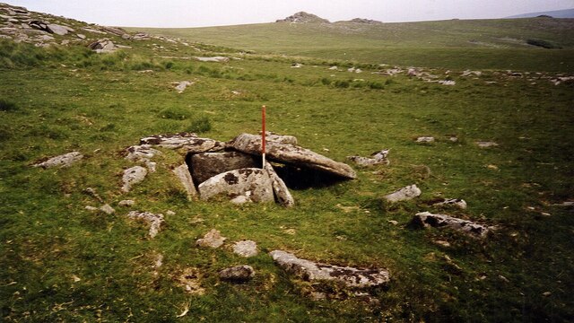
Dartmoor kistvaens are burial tombs or cists from the late Neolithic and early Bronze Age, i.e. from c. 2500 BC to c. 1500 BC. Kistvaens have been found...
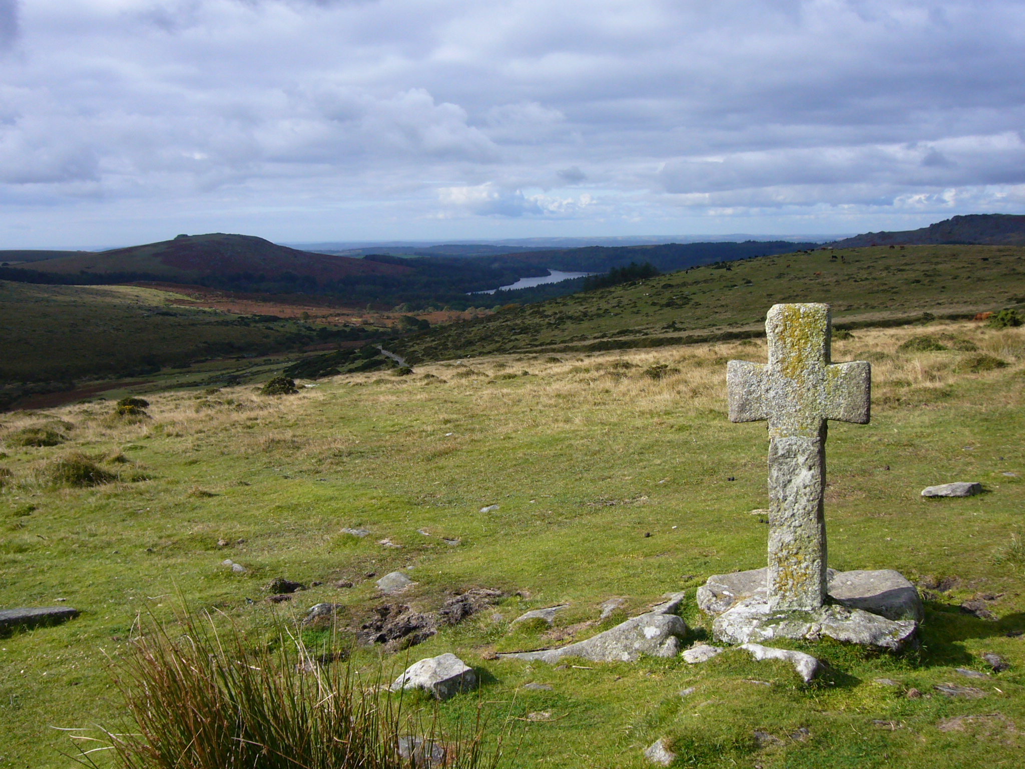
Dartmoor crosses

The Dartmoor crosses are a series of stone crosses found in Dartmoor National Park in the centre of Devon, England. Many of them are old navigational aids...

Nearby Amenities

Located within 500m of 50.579112,-3.97529
Beardown Tors
Ele: 514
Natural: peak
Source: NPE
Wikidata: Q4876675
Wikipedia: en:Beardown Tors
Lat/Long: 50.579146/-3.9754175
Merrivale Range
Barrier: bollard
Material: metal
Military: range_marker
Operator: Ministry of Defence
Lat/Long: 50.583054/-3.9770275
Merrivale Range
Barrier: bollard
Material: metal
Military: range_marker
Operator: Ministry of Defence
Lat/Long: 50.5794535/-3.9782781
Merrivale Range
Barrier: bollard
Material: metal
Military: range_marker
Operator: Ministry of Defence
Lat/Long: 50.581844/-3.977448
Merrivale Range
Barrier: bollard
Material: metal
Military: range_marker
Operator: Ministry of Defence
Lat/Long: 50.5804299/-3.9779155
Field Telephone Connection
Access: private
Description: Military field telephone connection socket in a concrete box with metal door.
Man Made: telephone
Military: field_telephone
Operator: Ministry of Defence
Ref: Beardown Tor
Usage: military
Website: https://webarchive.nationalarchives.gov.uk/20121026065214/http://www.mod.uk/NR/rdonlyres/EBF59C8C-8B0E-4349-B40B-B6566B658959/0/Okehampton_Artillery_Range_Observation_Posts.pdf
Lat/Long: 50.579578/-3.97449
Range Warning Flagpole
Flag Type: signal
Height: 6
Man Made: flagpole
Operator: Ministry of Defence
Ref: Beardown Tor
Website: https://webarchive.nationalarchives.gov.uk/20121026065214/http://www.mod.uk/NR/rdonlyres/EBF59C8C-8B0E-4349-B40B-B6566B658959/0/Okehampton_Artillery_Range_Observation_Posts.pdf
Lat/Long: 50.579611/-3.9715243
The data included in this document is from www.openstreetmap.org. The data is made available under ODbL.

Have you been to Beardown Tors?

Leave your review of Beardown Tors below (or comments, questions and feedback).