Aulich Hill
Hill, Mountain in Perthshire
Scotland
Aulich Hill

Aulich Hill is a prominent hill located in Perthshire, Scotland. It is situated in the southern part of the region, near the village of Dunning. Standing at an elevation of 462 meters (1,516 feet), Aulich Hill offers breathtaking panoramic views of the surrounding countryside.
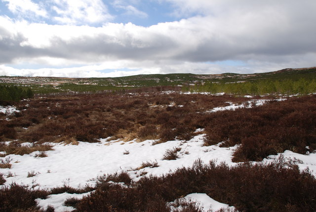
The hill is known for its distinctive shape, with a steep and rocky terrain, making it a popular destination for hikers and outdoor enthusiasts. Its summit is marked by a small cairn, providing a sense of accomplishment for those who reach the top.
Aulich Hill is covered in a mixture of heather, grasses, and moorland vegetation, creating a picturesque landscape throughout the year. The area is also home to various wildlife species, including red deer and a variety of birds, making it a haven for nature lovers.
The hill's strategic location and commanding views have made it of historical significance. It is believed to have been used as a lookout point during ancient times, and remnants of Iron Age hillforts can still be seen in the vicinity.
Access to Aulich Hill is relatively straightforward, with several walking trails leading to the summit. The hill is a popular destination for both locals and tourists, offering a great opportunity to immerse oneself in the natural beauty and history of Perthshire.
If you have any feedback on the listing, please let us know in the comments section below.
Aulich Hill Images
Images are sourced within 2km of 56.706347/-4.2898684 or Grid Reference NN5959. Thanks to Geograph Open Source API. All images are credited.


Aulich Hill is located at Grid Ref: NN5959 (Lat: 56.706347, Lng: -4.2898684)
Unitary Authority: Perth and Kinross
Police Authority: Tayside
What 3 Words
///tribal.worms.whips. Near Pubil, Perth & Kinross
Nearby Locations
Related Wikis

Loch Rannoch
Loch Rannoch (Scottish Gaelic: Loch Raineach) is a freshwater loch in Perth and Kinross, Scotland. It is over 15 kilometres (9.3 mi) long in a west–east...
Loch Rannoch and Glen Lyon National Scenic Area
The Loch Rannoch and Glen Lyon National Scenic Area is a national scenic area (NSA) covering the area surrounding Loch Rannoch, Glen Lyon, and the Ben...
Rannoch School
Rannoch School was an independent boarding school, located on the south shore of Loch Rannoch in Perth and Kinross, Scotland on the Dall Estate, 6 miles...

Rannoch
Rannoch (Scottish Gaelic: Raineach or Raithneach, meaning 'bracken') is an area of the Scottish Highlands between the A9 road, to the east, and the A82...
Dunalastair Hotel
The Dunalastair Hotel Suites is a grade listed, 5 star hotel located in Kinloch Rannoch, Perthshire. Originally established in 1788, the current building...

Kinloch Rannoch
Kinloch Rannoch (; Gaelic: Ceann Loch Raineach) is a village in Perth and Kinross, Scotland, at the eastern end of Loch Rannoch, 18 miles (29 km) west...

Beinn a' Chuallaich
Beinn a' Chuallaich is a Scottish hill, four kilometres northeast of the village of Kinloch Rannoch in the Perth and Kinross council area. It is part of...

River Ericht, Rannoch
The River Ericht (Scottish Gaelic: Eireachd) is a short river which flows generally southwards from the southern end of Loch Ericht for 3 miles / 5 km...
Have you been to Aulich Hill?
Leave your review of Aulich Hill below (or comments, questions and feedback).