Corse Hill

Hill, Mountain in Renfrewshire

Scotland

Corse Hill

Whitelee wind farm from the air Whitelee Windfarm is the UK's largest onshore windfarm. It is located on Eaglesham Moor just 20 minutes south of central Glasgow. The windfarm has 215 turbines which can generate 539MW of electricity, enough to power over 300,000 homes.

You can access the windfarm for free and experience the wind turbines up close with over 130kms of trails to explore.  The Visitor Centre <span class="nowrap"><a title="https://www.scottishpower.co.uk/whitelee/visitor-centre" rel="nofollow ugc noopener" href="https://www.scottishpower.co.uk/whitelee/visitor-centre">Link</a><img style="margin-left:2px;" alt="External link" title="External link - shift click to open in new window" src="https://s1.geograph.org.uk/img/external.png" width="10" height="10"/></span> is also free and has an interactive exhibition and a Cafe to relax after the long walk on the windfarm.
Whitelee wind farm from the air Credit: Thomas Nugent

Corse Hill is a prominent landmark located in Renfrewshire, Scotland. Standing at an elevation of 176 meters (577 feet), it is classified as a hill rather than a mountain. Situated near the village of Eaglesham, Corse Hill offers breathtaking views of the surrounding countryside and is a popular spot for outdoor enthusiasts and nature lovers.

The hill is characterized by its gently rolling slopes, covered with a mix of heather, grasses, and scattered trees. It is part of a larger area known as the East Renfrewshire Uplands, which comprises a network of hills and glens. Corse Hill itself is composed of sandstone, giving it a distinctive reddish hue.

The summit of Corse Hill is marked by a trig point, providing a reference point for mapping and navigation. From this vantage point, visitors can enjoy panoramic vistas that stretch across the Renfrewshire countryside, with views extending as far as the distant peaks of the Campsie Fells and the Trossachs.

The area surrounding Corse Hill is rich in wildlife, with various bird species, including grouse and curlews, frequently spotted in the heather moorland. The hill is also home to small mammals such as rabbits and foxes. Walking and hiking trails crisscross the hill, offering opportunities for exploration and outdoor activities.

Corse Hill is not only a natural attraction but also a site of historical significance. It features remnants of old settlements, with ancient cairns and stone circles dotting the landscape. This adds an element of intrigue and heritage to the hill, making it a fascinating destination for history enthusiasts as well.

If you have any feedback on the listing, please let us know in the comments section below.

Corse Hill Images

Images are sourced within 2km of 55.691368/-4.2313291 or Grid Reference NS5946. Thanks to Geograph Open Source API. All images are credited.

Whitelee wind farm from the air Whitelee Windfarm is the UK's largest onshore windfarm. It is located on Eaglesham Moor just 20 minutes south of central Glasgow. The windfarm has 215 turbines which can generate 539MW of electricity, enough to power over 300,000 homes.

You can access the windfarm for free and experience the wind turbines up close with over 130kms of trails to explore.  The Visitor Centre <span class="nowrap"><a title="https://www.scottishpower.co.uk/whitelee/visitor-centre" rel="nofollow ugc noopener" href="https://www.scottishpower.co.uk/whitelee/visitor-centre">Link</a><img style="margin-left:2px;" alt="External link" title="External link - shift click to open in new window" src="https://s1.geograph.org.uk/img/external.png" width="10" height="10"/></span> is also free and has an interactive exhibition and a Cafe to relax after the long walk on the windfarm.
Whitelee wind farm from the air
Whitelee Windfarm is the UK's largest onshore windfarm. It is located on Eaglesham Moor just 20 minutes south of central Glasgow. The windfarm has 215 turbines which can generate 539MW of electricity, enough to power over 300,000 homes. You can access the windfarm for free and experience the wind turbines up close with over 130kms of trails to explore. The Visitor Centre LinkExternal link is also free and has an interactive exhibition and a Cafe to relax after the long walk on the windfarm.
TrigPoint on Corse Hill
Corse Hill trig point Comparing this picture with <a href="https://www.geograph.org.uk/photo/886966">NS5946 : Corse Hill triangulation pillar</a> one sees the same barbed wire fence. Most of the installation inside the fence has gone, however, and the gate (off the right-hand side of the picture) lies open. Presumably the weather radar installation went with the advent of the enormous Whitelee Windfarm. Only a video camera remains inside the fence, rotating regularly on top of the pole to the left of the picture.
Corse Hill trig point
Comparing this picture with NS5946 : Corse Hill triangulation pillar one sees the same barbed wire fence. Most of the installation inside the fence has gone, however, and the gate (off the right-hand side of the picture) lies open. Presumably the weather radar installation went with the advent of the enormous Whitelee Windfarm. Only a video camera remains inside the fence, rotating regularly on top of the pole to the left of the picture.
Turbine 114 in Whitelee Windfarm Viewed from the track through an area of felled trees leading to the turbine.
There is also a good view over the Central Lowlands of Scotland.
Turbine 114 in Whitelee Windfarm
Viewed from the track through an area of felled trees leading to the turbine. There is also a good view over the Central Lowlands of Scotland.
Junction of tracks in Whitelee Windfarm The main track, Spine Road, is the one on the right and Myers Road branches off to the left. 6 of the turbines of the windfarm are in view. This is also an area of felled trees.
Junction of tracks in Whitelee Windfarm
The main track, Spine Road, is the one on the right and Myers Road branches off to the left. 6 of the turbines of the windfarm are in view. This is also an area of felled trees.
Corse Hill Trig Point This trig point is now in the middle of Whitelee Windfarm with 3 of the turbines in the background.
Corse Hill Trig Point
This trig point is now in the middle of Whitelee Windfarm with 3 of the turbines in the background.
Whitelee Widfarm Many of the turbines of Whitelee Widfarm, the largest in the United Kingdom, in view here viewed from close to the Corse Hill trig point. The track running across the photograph is the Spine Road.
Whitelee Widfarm
Many of the turbines of Whitelee Widfarm, the largest in the United Kingdom, in view here viewed from close to the Corse Hill trig point. The track running across the photograph is the Spine Road.
Drumduff Hill is no longer remote Things have changed since the preceding image <a href="https://www.geograph.org.uk/photo/346170">NS5846 : Drumduff Hill</a>.
Drumduff Hill is no longer remote
Things have changed since the preceding image NS5846 : Drumduff Hill.
Drumduff Hill Drumduff Hill has changed a bit from the first submission <a href="https://www.geograph.org.uk/photo/346170">NS5846 : Drumduff Hill</a>
Drumduff Hill
Drumduff Hill has changed a bit from the first submission NS5846 : Drumduff Hill
Whitelee Wind Farm The south side of Drumduff Hill.
Whitelee Wind Farm
The south side of Drumduff Hill.
Burn on Corse Hill Moorland dominated by the turbines of Whitelee Wind Farm.  This is close to the Renfrewshire - Lanarkshire march.
Burn on Corse Hill
Moorland dominated by the turbines of Whitelee Wind Farm. This is close to the Renfrewshire - Lanarkshire march.
Summit, Corse Hill Corse Hill has changed since I last visited <a href="https://www.geograph.org.uk/photo/13031">NS5946 : Weather radar</a>. The wind turbines have replaced the weather radar.
Summit, Corse Hill
Corse Hill has changed since I last visited NS5946 : Weather radar. The wind turbines have replaced the weather radar.
Summit, Corse Hill The enclosure remains from the weather radar. Before the wind farm, the summit looked like this: <a href="https://www.geograph.org.uk/photo/13031">NS5946 : Weather radar</a>.
Summit, Corse Hill
The enclosure remains from the weather radar. Before the wind farm, the summit looked like this: NS5946 : Weather radar.
Summit, Corse Hill Now the hill is in the centre of a wind farm, biggest in Britain so they say but that is now meaningless as the developments merge as the turbines take over. Part of the array on this hill is called Browncastle for instance. Anyway there are hundreds of them.
Summit, Corse Hill
Now the hill is in the centre of a wind farm, biggest in Britain so they say but that is now meaningless as the developments merge as the turbines take over. Part of the array on this hill is called Browncastle for instance. Anyway there are hundreds of them.
Corse Hill triangulation pillar The enclosure used to protect a radar installation.
Corse Hill triangulation pillar
The enclosure used to protect a radar installation.
Whitelee Wind Farm The future for much of the Highlands. Enjoy it while you can.
Whitelee Wind Farm
The future for much of the Highlands. Enjoy it while you can.
Spine Road in Whitelee Windfarm The main track through the extensive windfarm with turbine 116 also in the foreground.
Spine Road in Whitelee Windfarm
The main track through the extensive windfarm with turbine 116 also in the foreground.
Turbine 122 in Whitelee Windfarm Turbine 114 in the background.
Turbine 122 in Whitelee Windfarm
Turbine 114 in the background.
Show me another place!

Corse Hill is located at Grid Ref: NS5946 (Lat: 55.691368, Lng: -4.2313291)

Unitary Authority: East Renfrewshire

Police Authority: Greater Glasgow

What 3 Words

///aimed.something.sheet. Near Eaglesham, East Renfrewshire

Nearby Locations

Corse Hill

Related Wikis

Corse Hill

Corse Hill is a hill located between East Renfrewshire and South Lanarkshire of Scotland. With a height of 376 m (1,234 ft), it is the highest point in...
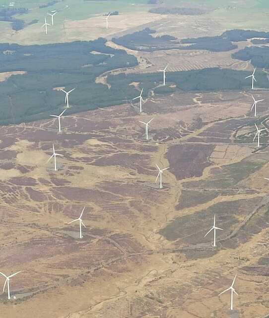
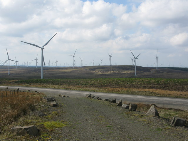
Whitelee Wind Farm

Whitelee Wind Farm is a windfarm on the Eaglesham moor in Scotland. The main visitor centre is located in East Renfrewshire, but the majority of turbines...

Auldhouse, South Lanarkshire

Auldhouse is a hamlet in South Lanarkshire, around 0.5 miles (0.80 km) to the south of the suburban edge of East Kilbride. == History == The first mention...

Millhall

Millhall is a hamlet in East Renfrewshire, in the Central Lowlands of Scotland. It lies 0.8 miles (1.3 km) southeast of Eaglesham, 8.3 miles (13.4 km)...

Nearby Amenities

Located within 500m of 55.691368,-4.2313291
104
Generator Method: wind_turbine
Generator Source: wind
Generator Type: horizontal_axis
Power: generator
Source: survey
Lat/Long: 55.6910937/-4.2320578
Corse Hill
Corbett: no
Ele: 376
Graham: no
Marilyn: yes
Munro: no
Natural: peak
Prominence: 173
Wikidata: Q24652015
Lat/Long: 55.6913319/-4.2312725
105
Generator Method: wind_turbine
Generator Output Electricity: 2.3 MW
Generator Source: wind
Generator Type: horizontal_axis
Power: generator
Source: bing
Lat/Long: 55.6876636/-4.2326353
Generator Method: wind_turbine
Generator Output Electricity: 2.3 MW
Generator Source: wind
Generator Type: horizontal_axis
Power: generator
Source: bing
Lat/Long: 55.6901423/-4.2259118
103
Generator Method: wind_turbine
Generator Output Electricity: 2.3 MW
Generator Source: wind
Generator Type: horizontal_axis
Power: generator
Source: bing
Lat/Long: 55.6924141/-4.2377433
115
Generator Method: wind_turbine
Generator Output Electricity: 2.3 MW
Generator Source: wind
Generator Type: horizontal_axis
Power: generator
Source: bing
Lat/Long: 55.6950677/-4.2303597
The data included in this document is from www.openstreetmap.org. The data is made available under ODbL.

Have you been to Corse Hill?

Leave your review of Corse Hill below (or comments, questions and feedback).