Balscote

Settlement in Oxfordshire Cherwell

England

Balscote

George and Dragon, Shutford yes, there is pub, it's not all church - Hook Norton beers
George and Dragon, Shutford Credit: al partington

Balscote is a small village located in Oxfordshire, England. Situated approximately 15 miles north of Oxford, it falls within the Cherwell district. As of the 2011 census, the village had a population of around 600 residents.

The village is characterized by its picturesque rural setting, surrounded by rolling hills and open countryside. Balscote is primarily an agricultural community, with farming being a key economic activity in the area. The landscape is dotted with farms and fields, contributing to the village's tranquil and idyllic atmosphere.

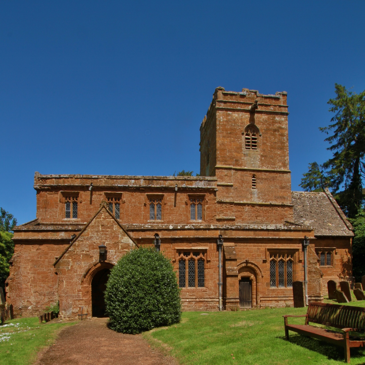
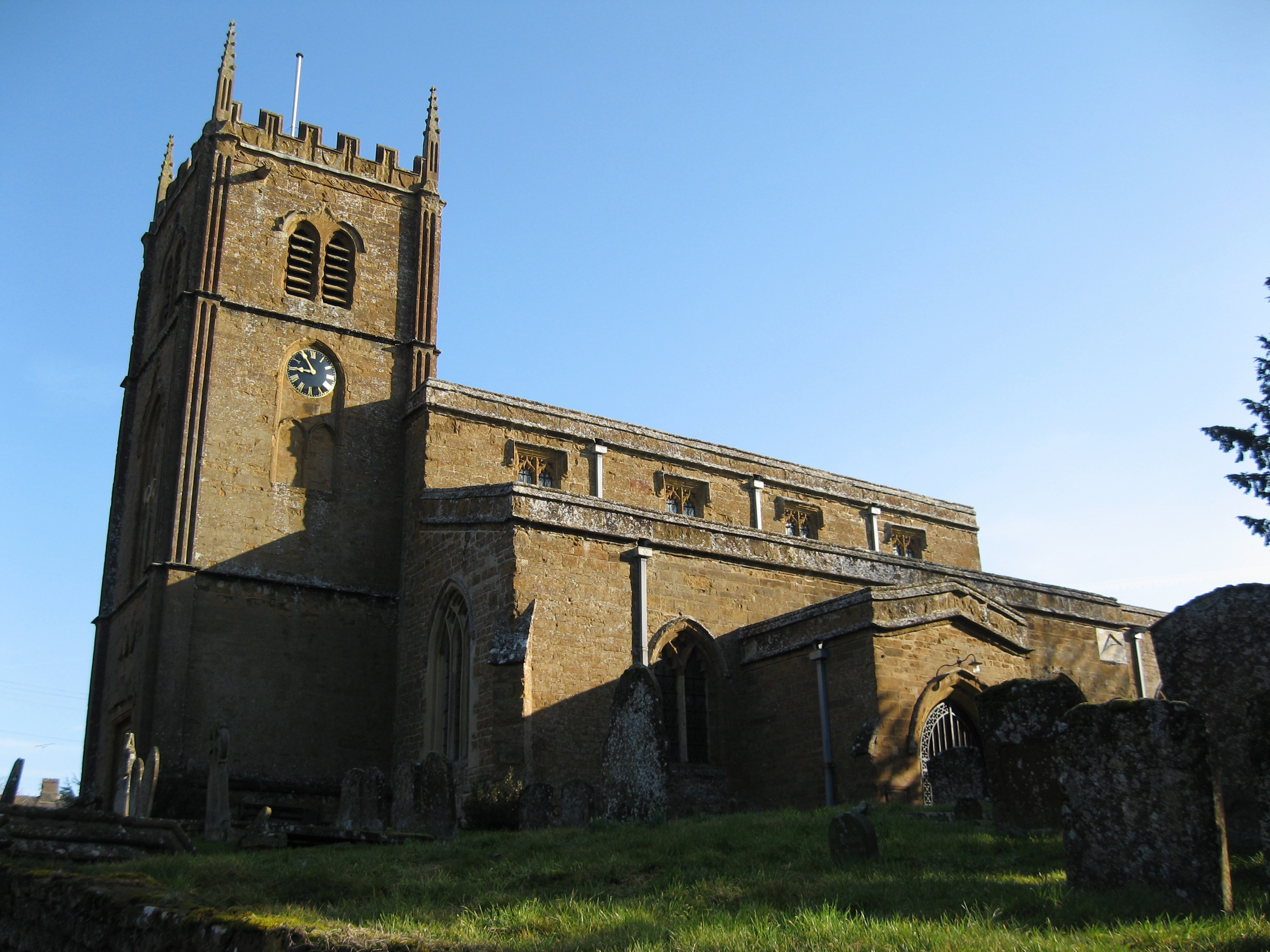
Despite its small size, Balscote boasts a rich history. The village is believed to have existed since at least the 11th century, as evidenced by the presence of a Norman church, St. Mary's, which dates back to the 12th century. The church is a prominent feature in the village and serves as a reminder of Balscote's long-standing heritage.

In terms of amenities, Balscote offers a limited range of services. There is a village hall that serves as a community hub, hosting various events and activities throughout the year. However, residents often rely on nearby towns for additional amenities, such as shops, schools, and healthcare facilities.

Balscote's proximity to larger towns, such as Banbury and Oxford, allows residents to access a wider range of services and employment opportunities. The village also benefits from good transportation links, with regular bus services connecting it to nearby towns and villages.

If you have any feedback on the listing, please let us know in the comments section below.

Balscote Images

Images are sourced within 2km of 52.071834/-1.431563 or Grid Reference SP3941. Thanks to Geograph Open Source API. All images are credited.

George and Dragon, Shutford yes, there is pub, it's not all church - Hook Norton beers
George and Dragon, Shutford
yes, there is pub, it's not all church - Hook Norton beers
Butchers Arms, Balscote Hook Norton brewery gem of a pub
Butchers Arms, Balscote
Hook Norton brewery gem of a pub
Driveway to Stonepit Cottage The driveway to the cottage from Epwell Road.  The grass has just been cut and the birds seem to be massing on the power lines ready to dive on any disturbed insects.
Driveway to Stonepit Cottage
The driveway to the cottage from Epwell Road. The grass has just been cut and the birds seem to be massing on the power lines ready to dive on any disturbed insects.
Stonepit Cottage sign A place to visit for those tying the knot!
Stonepit Cottage sign
A place to visit for those tying the knot!
The New Inn, Wroxton Heath Built from local Ironstone and shown on the OS Map beside the Stratford Road.
The New Inn, Wroxton Heath
Built from local Ironstone and shown on the OS Map beside the Stratford Road.
Heath Farm The sign just inside the ornate gateway proclaims this to be "Jenny's Sanctuary.  An educational centre for the Development and Promotion of Spiritual Gifts". <span class="nowrap"><a title="http://www.jennyssanctuary.org.uk/" rel="nofollow ugc noopener" href="http://www.jennyssanctuary.org.uk/">Link</a><img style="margin-left:2px;" alt="External link" title="External link - shift click to open in new window" src="https://s1.geograph.org.uk/img/external.png" width="10" height="10"/></span>
Heath Farm
The sign just inside the ornate gateway proclaims this to be "Jenny's Sanctuary. An educational centre for the Development and Promotion of Spiritual Gifts". LinkExternal link
View towards Shenington Looking across the north of the square from the bridleway near Alkerton towards Shenington, visible on top of the hill in the distance.
View towards Shenington
Looking across the north of the square from the bridleway near Alkerton towards Shenington, visible on top of the hill in the distance.
Wroxton Mill
Wroxton Mill
Stratford Road bridge and Balscote ironstone quarry The bridge parapet in the foreground is that of a bridge under the Stratford Road built in 1954 to allow the Oxfordshire Ironstone Quarries to extract the ironstone from the land visible beyond.  This was the Balscote Quarry which was worked between 1956 and the closure of the entire quarry system in 1967. The bridge provided a link for removal of ironstone via the quarry railway network back to <a href="https://www.geograph.org.uk/photo/199178">SP4042 : Oxfordshire Ironstone Quarries Headquarters site</a> at Wroxton for processing.
Stratford Road bridge and Balscote ironstone quarry
The bridge parapet in the foreground is that of a bridge under the Stratford Road built in 1954 to allow the Oxfordshire Ironstone Quarries to extract the ironstone from the land visible beyond. This was the Balscote Quarry which was worked between 1956 and the closure of the entire quarry system in 1967. The bridge provided a link for removal of ironstone via the quarry railway network back to SP4042 : Oxfordshire Ironstone Quarries Headquarters site at Wroxton for processing.
Balscote Methodist Church This small local ironstone building is shown on the OS map by the road in the north of the village.  The black sign by the doorway proudly proclaims it to be Balscote Methodist Church.
Balscote Methodist Church
This small local ironstone building is shown on the OS map by the road in the north of the village. The black sign by the doorway proudly proclaims it to be Balscote Methodist Church.
Course of Ironstone quarry railway The course of the railway from <a href="https://www.geograph.org.uk/photo/199178">SP4042 : Oxfordshire Ironstone Quarries Headquarters site</a>, seen looking west from Dyke Lane bridge shows up as lighter line across the field of wheat.  This whole area as far as the trees was quarried for ironstone between 1941 and 1949 and as a result the level of the land has been reduced by 15-20 metres, as can be seen in this picture of <a href="https://www.geograph.org.uk/photo/199177">SP3943 : Dyke Lane Bridge</a>. After the ironstone was exhausted the land was returned to farming and the railway was extended towards Alkerton to tap fresh reserves. 
Compare this view with picture 11 on <span class="nowrap"><a title="http://www.deddington.org.uk/history/ironstone/ironstonepics.html" rel="nofollow ugc noopener" href="http://www.deddington.org.uk/history/ironstone/ironstonepics.html">Link</a><img style="margin-left:2px;" alt="External link" title="External link - shift click to open in new window" src="https://s1.geograph.org.uk/img/external.png" width="10" height="10"/></span>
Course of Ironstone quarry railway
The course of the railway from SP4042 : Oxfordshire Ironstone Quarries Headquarters site, seen looking west from Dyke Lane bridge shows up as lighter line across the field of wheat. This whole area as far as the trees was quarried for ironstone between 1941 and 1949 and as a result the level of the land has been reduced by 15-20 metres, as can be seen in this picture of SP3943 : Dyke Lane Bridge. After the ironstone was exhausted the land was returned to farming and the railway was extended towards Alkerton to tap fresh reserves. Compare this view with picture 11 on LinkExternal link
Alkerton Barn
Alkerton Barn
Bridleway to Shenington This well used bridleway drops steeply down from the lane near Alkerton before meeting other paths in the bottom of the valley and becoming Mill Lane to Shenington.
Bridleway to Shenington
This well used bridleway drops steeply down from the lane near Alkerton before meeting other paths in the bottom of the valley and becoming Mill Lane to Shenington.
Golf course at Wroxton Mill This course is not shown on the OS Map and is discreetly hidden away in the little valley above Wroxton Mill.
Golf course at Wroxton Mill
This course is not shown on the OS Map and is discreetly hidden away in the little valley above Wroxton Mill.
Balscote A marker stone commemorating the millennium situated on a green in the SE corner of the village.
Balscote
A marker stone commemorating the millennium situated on a green in the SE corner of the village.
Site of Langley Ironstone Quarry The whole of the area in this picture as far as the woods and the far lines of trees was quarried for ironstone between 1926 and 1943.  The ironstone was not far below the surface and as it was removed the land was returned to cultivation - but 15-20 metres below its previous level.  This view is from the bridge constructed under the Stratford Road in 1954 to allow access to open up the Balscott Quarry area.  The shallow depression across the fields leading away from the photographer marks the course of the railway from the newer quarry area back to the <a href="https://www.geograph.org.uk/photo/199178">SP4042 : Oxfordshire Ironstone Quarries Headquarters site</a> which is just visible to the right of the woodland in the centre of the picture.
Site of Langley Ironstone Quarry
The whole of the area in this picture as far as the woods and the far lines of trees was quarried for ironstone between 1926 and 1943. The ironstone was not far below the surface and as it was removed the land was returned to cultivation - but 15-20 metres below its previous level. This view is from the bridge constructed under the Stratford Road in 1954 to allow access to open up the Balscott Quarry area. The shallow depression across the fields leading away from the photographer marks the course of the railway from the newer quarry area back to the SP4042 : Oxfordshire Ironstone Quarries Headquarters site which is just visible to the right of the woodland in the centre of the picture.
Dyke Lane Bridge Looking across the farmland that was reinstated  at about 15-20 metres below its previous level after the quarrying of ironstone in the 1940s.  As a result Dyke Lane now appears to be on an embankment.  The bridge was built to provide a rail connection to the <a href="https://www.geograph.org.uk/photo/199178">SP4042 : Oxfordshire Ironstone Quarries Headquarters site</a> at Wroxton and the line was subsequently extended towards Alkerton.  The <a href="https://www.geograph.org.uk/photo/197430">SP3943 : Course of Ironstone quarry railway</a> can still be seen from the bridge.
Dyke Lane Bridge
Looking across the farmland that was reinstated at about 15-20 metres below its previous level after the quarrying of ironstone in the 1940s. As a result Dyke Lane now appears to be on an embankment. The bridge was built to provide a rail connection to the SP4042 : Oxfordshire Ironstone Quarries Headquarters site at Wroxton and the line was subsequently extended towards Alkerton. The SP3943 : Course of Ironstone quarry railway can still be seen from the bridge.
View towards Tythe Farm Looking across the square from Shutford Road.
View towards Tythe Farm
Looking across the square from Shutford Road.
Show me another place!

Balscote is located at Grid Ref: SP3941 (Lat: 52.071834, Lng: -1.431563)

Administrative County: Oxfordshire

District: Cherwell

Police Authority: Thames Valley

What 3 Words

///decorate.craftsmen.stow. Near Banbury, Oxfordshire

Nearby Locations

Balscote

Related Wikis

Balscote

Balscote or Balscott is a village in the civil parish of Wroxton, Oxfordshire, about 4 miles (6.4 km) west of Banbury. The Domesday Book of 1086 records...

Shutford

Shutford is a village and civil parish about 4.5 miles (7.2 km) west of Banbury in Oxfordshire. The village is about 475 feet (145 m) above sea level....

Shenington with Alkerton

Shenington with Alkerton is a civil parish in Oxfordshire, England. It comprises the village of Shenington, which was an exclave of Gloucestershire until...

Alkerton, Oxfordshire

Alkerton is a village and former civil parish, now in the parish of Shenington with Alkerton, in the Cherwell district, in the county of Oxfordshire, England...

Wroxton

Wroxton is a village and civil parish in the north of Oxfordshire about 3 miles (5 km) west of Banbury. The 2011 Census recorded the parish's population...

Shenington

Shenington is a village and former civil parish, now in the parish of Shenington with Alkerton, in the Cherwell district, in the county of Oxfordshire...

Oxfordshire Ironstone Railway

The Oxfordshire Ironstone Railway was a standard-gauge mineral railway that served an ironstone quarry near the village of Wroxton in Oxfordshire. ��2...

Wroxton Abbey

Wroxton Abbey is a Jacobean house in Oxfordshire, with a 1727 garden partly converted to the serpentine style between 1731 and 1751. It is 2.5 miles (4...

Nearby Amenities

Located within 500m of 52.071834,-1.431563
Bus Stop
Church
Bus: yes
Naptan AtcoCode: 340000070BA
Naptan Bearing: SW
Naptan BusStopType: CUS
Naptan CommonName: Church
Naptan Indicator: Outside
Naptan Landmark: Church
Naptan NaptanCode: oxfamgaw
Naptan Street: Village Road
Naptan Verified: no
Public Transport: platform
Source: naptan_import
Lat/Long: 52.0734201/-1.4321106
Bus Stop
Church
Bus: yes
Naptan AtcoCode: 340000070BAO
Naptan Bearing: NE
Naptan BusStopType: CUS
Naptan CommonName: Church
Naptan Indicator: Opposite
Naptan Landmark: Church
Naptan NaptanCode: oxfgapjg
Naptan Street: Village Road
Naptan Verified: no
Public Transport: platform
Source: naptan_import
Lat/Long: 52.0735018/-1.43227
Balscote
Alt Name: Balscott
Place: village
Wikidata: Q4852566
Wikipedia: en:Balscote
Lat/Long: 52.0730326/-1.4325587
Well
Man Made: water_well
Source: OS_OpenData_StreetView
Lat/Long: 52.0732079/-1.4291166
Recycling
Source: Bing
Lat/Long: 52.0722145/-1.4338161
Power: tower
Source: visual survey;estimate
Lat/Long: 52.0746959/-1.4349891
Power: tower
Source: visual survey;estimate
Lat/Long: 52.0738253/-1.4372995
Power: tower
Source: visual survey;estimate
Lat/Long: 52.0754839/-1.4328916
Power: pole
Lat/Long: 52.0752383/-1.4280162
Power: pole
Lat/Long: 52.0716229/-1.4305864
Power: pole
Lat/Long: 52.0714455/-1.4309767
Power: pole
Lat/Long: 52.0710244/-1.4319545
Power: pole
Lat/Long: 52.0703909/-1.4333408
Power: pole
Lat/Long: 52.0693151/-1.4358187
Power: pole
Lat/Long: 52.0724931/-1.4265618
Power: pole
Lat/Long: 52.0722003/-1.4257717
Power: pole
Lat/Long: 52.072077/-1.4254421
Power: pole
Lat/Long: 52.0727182/-1.4272288
Power: pole
Lat/Long: 52.0733243/-1.4289045
Power: pole
Lat/Long: 52.073485/-1.4293432
Power: pole
Lat/Long: 52.0741782/-1.4292527
Power: pole
Lat/Long: 52.0739437/-1.4295231
Power: pole
Lat/Long: 52.0747581/-1.4285763
Power: pole
Lat/Long: 52.0698211/-1.4346247
The data included in this document is from www.openstreetmap.org. The data is made available under ODbL.

Have you been to Balscote?

Leave your review of Balscote below (or comments, questions and feedback).