Dunglass

Hill, Mountain in Stirlingshire

Scotland

Dunglass

Ballagan Burn The burn looks relatively placid here, but it is about to tumble over the Spout of Ballagan.
Ballagan Burn Credit: Mark Nightingale

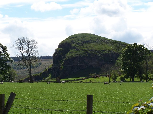
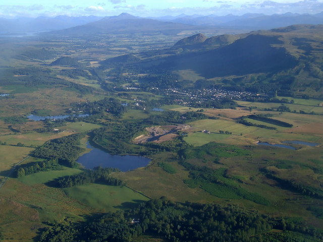
Dunglass is a prominent hill located in the region of Stirlingshire, Scotland. Standing at an elevation of approximately 520 meters (1,706 feet), it offers breathtaking panoramic views of the surrounding countryside. Situated about 6 kilometers (3.7 miles) northwest of the town of Dunblane, Dunglass is a popular destination for hikers, nature enthusiasts, and outdoor adventurers.

The hill is characterized by its rugged and rocky terrain, making it an exciting and challenging climb for those seeking a thrilling outdoor experience. Dunglass is covered in heather and grasses, creating a picturesque landscape that changes color with the seasons.

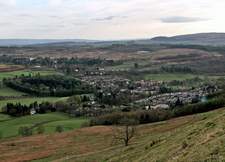
The ascent to the summit of Dunglass can be approached from various directions, with a number of well-marked trails available for visitors to choose from. The most popular route starts from the village of Kinbuck, leading hikers through a mixture of woodland and open moorland before reaching the summit.

At the top, visitors are rewarded with awe-inspiring views of the surrounding Stirlingshire countryside, including the River Forth and the Ochil Hills in the distance. On clear days, it is even possible to catch a glimpse of the iconic Stirling Castle.

Dunglass is also home to a diverse range of flora and fauna, including various bird species and small mammals. The hill's remote location and natural beauty make it a haven for wildlife, attracting birdwatchers and nature photographers.

Overall, Dunglass offers an invigorating and memorable experience for outdoor enthusiasts, combining challenging hiking trails with stunning vistas of the Scottish countryside.

If you have any feedback on the listing, please let us know in the comments section below.

Dunglass Images

Images are sourced within 2km of 55.981939/-4.284398 or Grid Reference NS5778. Thanks to Geograph Open Source API. All images are credited.

Ballagan Burn The burn looks relatively placid here, but it is about to tumble over the Spout of Ballagan.
Ballagan Burn
The burn looks relatively placid here, but it is about to tumble over the Spout of Ballagan.
The Clachachter Stone Named the Clachachter Stone on the OS 1:25000 maps.  It is the biggest of a group of stones lying on a grassy Campsie hillside.
The Clachachter Stone
Named the Clachachter Stone on the OS 1:25000 maps. It is the biggest of a group of stones lying on a grassy Campsie hillside.
The Spout of Ballagan This 21-metre fall is a highlight of the area. It displays a classic section of the calciferous sandstones called the Ballagan Beds. There is a fine building sandstone, Spout of Ballagan sandstone, at the top which is hard enough to cause the fall, and beneath it are alternating layers of cementstones & shales. These were laid down in the Carboniferous era c350million years ago when this whole area was the bed of a tropical lagoon south of the equator. Park in the village of Strathblane (opposite the church) & walk along the road to the entrance to Ballagan House. At the back of this is a stile & sign that takes you up to the nature reserve and fall. The actual approach to the foot of the fall is quite rough going but the path takes you to the top of it easily from where you can continue on up onto The Campsies.
The Spout of Ballagan
This 21-metre fall is a highlight of the area. It displays a classic section of the calciferous sandstones called the Ballagan Beds. There is a fine building sandstone, Spout of Ballagan sandstone, at the top which is hard enough to cause the fall, and beneath it are alternating layers of cementstones & shales. These were laid down in the Carboniferous era c350million years ago when this whole area was the bed of a tropical lagoon south of the equator. Park in the village of Strathblane (opposite the church) & walk along the road to the entrance to Ballagan House. At the back of this is a stile & sign that takes you up to the nature reserve and fall. The actual approach to the foot of the fall is quite rough going but the path takes you to the top of it easily from where you can continue on up onto The Campsies.
Fence crossing the Campsie Fells Just to the east of the fence junction - following in the opposite direction leads to the summit of Dumbreck.
Fence crossing the Campsie Fells
Just to the east of the fence junction - following in the opposite direction leads to the summit of Dumbreck.
Heading towards Dumbreck In the Campsie Fells.
Heading towards Dumbreck
In the Campsie Fells.
Isolated rock in the moorland above Fin Glen
Ballagan Glen The wooded gorge of Ballagan Glen, just below the Spout of Ballagan (waterfall).  The site is a Scottish Wildlife Trust Reserve and a Site of Special Scientific Interest on account of its geology.
Ballagan Glen
The wooded gorge of Ballagan Glen, just below the Spout of Ballagan (waterfall). The site is a Scottish Wildlife Trust Reserve and a Site of Special Scientific Interest on account of its geology.
The Ballagan Beds, Ballagan Glen The rock face shows the Ballagan Beds, a sequence of cementstones and mudstones of Carboniferous age.
The Ballagan Beds, Ballagan Glen
The rock face shows the Ballagan Beds, a sequence of cementstones and mudstones of Carboniferous age.
Strathblane Hills Long range photo from Muirhouse Muir.
Strathblane Hills
Long range photo from Muirhouse Muir.
The Campsie Fells from the air The Strathblane Hills are in the foreground with the Campsie Fells beyond.
The Campsie Fells from the air
The Strathblane Hills are in the foreground with the Campsie Fells beyond.
Ballagan Glen The wooded gorge of Ballagan Glen, just below the Spout of Ballagan (waterfall). The site is a Scottish Wildlife Trust Reserve and a Site of Special Scientific Interest on account of its geology.
Ballagan Glen
The wooded gorge of Ballagan Glen, just below the Spout of Ballagan (waterfall). The site is a Scottish Wildlife Trust Reserve and a Site of Special Scientific Interest on account of its geology.
The Ballagan Beds, Ballagan Glen The rock face shows the Ballagan Beds, a sequence of cementstones and mudstones of Carboniferous age, named after their occurrence here. The height of the cliff is apparent from the size of the person at the bottom right.
The Ballagan Beds, Ballagan Glen
The rock face shows the Ballagan Beds, a sequence of cementstones and mudstones of Carboniferous age, named after their occurrence here. The height of the cliff is apparent from the size of the person at the bottom right.
Ballagan Glen Seen from the slope of Dunglass. The Spout of Ballagan waterfall is just visible.
Ballagan Glen
Seen from the slope of Dunglass. The Spout of Ballagan waterfall is just visible.
Binnen One of the crags of the Strathblane Hills, seen from Strathblane.
Binnen
One of the crags of the Strathblane Hills, seen from Strathblane.
Binnen, Strathblane Hills Presumably the name of this outcrop is a variant of the Gaelic 'binnein', which denotes a peaked hill.

The village of Strathblane is visible below, with Glasgow in the far distance.
Binnen, Strathblane Hills
Presumably the name of this outcrop is a variant of the Gaelic 'binnein', which denotes a peaked hill. The village of Strathblane is visible below, with Glasgow in the far distance.
Cliffs near Binnen, Strathblane Hills Loch Lomond is visible in the distance.
Cliffs near Binnen, Strathblane Hills
Loch Lomond is visible in the distance.
The Strathblane Hills A zoomed view, looking from the Strathblane Wildlife Sanctuary to the Strathblane Hills behind Blanefield. In the distance the clouds are starting to disperse from the top of the hills, as the day warms up.
The Strathblane Hills
A zoomed view, looking from the Strathblane Wildlife Sanctuary to the Strathblane Hills behind Blanefield. In the distance the clouds are starting to disperse from the top of the hills, as the day warms up.
Dunglass, Strathblane A strange mound.
Dunglass, Strathblane
A strange mound.
Show me another place!

Dunglass is located at Grid Ref: NS5778 (Lat: 55.981939, Lng: -4.284398)

Unitary Authority: Stirling

Police Authority: Forth Valley

What 3 Words

///resort.fidgeting.fighters. Near Strathblane, Stirling

Nearby Locations

Dunglass

Related Wikis

Strathblane railway station

Strathblane railway station served the village of Strathblane, Stirling, Scotland from 1867 to 1951 on the Blane Valley Railway. == History == The station...

Blanefield

Blanefield is a settlement in Scotland contiguous with Strathblane's northwestern fringe. To the west is the volcanic plug Dumgoyne, Glengoyne Distillery...

Strathblane

Strathblane (Scottish Gaelic: Strath Bhlàthain, pronounced [s̪t̪ɾahˈvl̪ˠaː.ɪɲ]) is a village and parish in the registration county of Stirlingshire, situated...

Loch Ardinning

Loch Ardinning (Scottish Gaelic: Loch Àird Dùnain) is a body of freshwater in the district of Stirling in Scotland, lying to the south of the village of...

Nearby Amenities

Located within 500m of 55.981939,-4.284398
Dunglass
Natural: peak
Source: bing
Source Name: OS_OpenData_StreetView
Lat/Long: 55.9822556/-4.2847808
Ballagan Burn
Place: isolated_dwelling
Lat/Long: 55.9859886/-4.2823196
Power: pole
Lat/Long: 55.9848455/-4.2902184
Power: pole
Lat/Long: 55.9847916/-4.2890701
Power: pole
Lat/Long: 55.984563/-4.2874043
Power: pole
Lat/Long: 55.984359/-4.2859647
Power: pole
Lat/Long: 55.9841586/-4.2845063
Power: pole
Lat/Long: 55.9839569/-4.2830563
Power: pole
Lat/Long: 55.9837963/-4.2818829
Power: pole
Lat/Long: 55.9836322/-4.2807241
Power: pole
Lat/Long: 55.9834693/-4.279536
Power: pole
Lat/Long: 55.9833075/-4.2783919
Power: pole
Lat/Long: 55.9831633/-4.2769063
Power: pole
Lat/Long: 55.9842101/-4.2910859
Power: pole
Lat/Long: 55.9835021/-4.2908575
Power: pole
Lat/Long: 55.9827659/-4.2906165
Power: pole
Lat/Long: 55.9819829/-4.2903546
Power: pole
Lat/Long: 55.9813276/-4.2905034
Power: pole
Lat/Long: 55.9806769/-4.2906459
Power: pole
Lat/Long: 55.9798856/-4.2908449
Power: pole
Lat/Long: 55.9851491/-4.287618
Power: pole
Lat/Long: 55.9858418/-4.287859
Power: pole
Lat/Long: 55.9837952/-4.2780399
The data included in this document is from www.openstreetmap.org. The data is made available under ODbL.

Have you been to Dunglass?

Leave your review of Dunglass below (or comments, questions and feedback).