An Sgùlan

Hill, Mountain in Perthshire

Scotland

An Sgùlan

Summit cairn on Beinn Udlamain
Summit cairn on Beinn Udlamain Credit: Steven Brown

An Sgùlan is a prominent hill located in the county of Perthshire, Scotland. It is part of the Grampian Mountains, specifically within the southern Cairngorms range. The hill stands at an elevation of approximately 916 meters (3,005 feet) above sea level, making it a popular destination for hikers and outdoor enthusiasts.

An Sgùlan offers breathtaking views of the surrounding landscape, with its steep slopes covered in heather and scattered boulders. The ascent to the summit is challenging, but the reward is a panoramic vista of rolling hills, deep valleys, and nearby lochs. On clear days, it is even possible to see some of Scotland's highest peaks, such as Ben Lawers and Schiehallion.

The hill is accessible from various starting points, including Glen Tilt to the east and Glen Bruar to the west. Both routes provide different perspectives of the hill and offer opportunities to spot wildlife such as red deer, mountain hares, and golden eagles.

An Sgùlan is steeped in history and folklore. The name itself is Gaelic, meaning "the little peak," which reflects its size compared to other nearby mountains. Local legends tell tales of ancient battles and mythical creatures that once roamed the area.

With its scenic beauty, challenging terrain, and historical significance, An Sgùlan is a captivating destination for those seeking outdoor adventures and an appreciation for Scotland's natural wonders.

If you have any feedback on the listing, please let us know in the comments section below.

An Sgùlan Images

Images are sourced within 2km of 56.819273/-4.3439019 or Grid Reference NN5772. Thanks to Geograph Open Source API. All images are credited.

Summit cairn on Beinn Udlamain
Western slopes of Mam Ban The western slopes of Mam Ban, with the bulk of the winter's snowfall now melted in early March.
Western slopes of Mam Ban
The western slopes of Mam Ban, with the bulk of the winter's snowfall now melted in early March.
Ruined walls or pile of stones In the middle of the moorland I came across this pile of stones that appeared to be rectangular in shape that could suggest a ruined sheiling or it may just be a pile of stones
Ruined walls or pile of stones
In the middle of the moorland I came across this pile of stones that appeared to be rectangular in shape that could suggest a ruined sheiling or it may just be a pile of stones
A Snow Bridge A patch of snow on the upper reaches of Allt Coire Dhomhain, hold right onto wet grass or make new footprints in the snow.
A Snow Bridge
A patch of snow on the upper reaches of Allt Coire Dhomhain, hold right onto wet grass or make new footprints in the snow.
Rock sculpture This little pile of rocks grabbed my attention, it reminded me of the Inukshuk I saw in the National Museum of Scotland, albeit a bit smaller.
Rock sculpture
This little pile of rocks grabbed my attention, it reminded me of the Inukshuk I saw in the National Museum of Scotland, albeit a bit smaller.
Beinn Udlamain summit cairn  Munro #61 A fantastic summit cairn, shelters and flat rocks to sit on on all sides, so at least you can get some shelter from just about any direction of wind.  The fence post sculpture I have seen in other photographs is now all piled up on the cairn.
Beinn Udlamain summit cairn Munro #61
A fantastic summit cairn, shelters and flat rocks to sit on on all sides, so at least you can get some shelter from just about any direction of wind. The fence post sculpture I have seen in other photographs is now all piled up on the cairn.
County boundary fence County boundary fence, Rowan and Birch trees on the East bank of Loch Ericht
County boundary fence
County boundary fence, Rowan and Birch trees on the East bank of Loch Ericht
Carn 'Ic Loumhaidh A view to the north from Carn 'Ic Loumhaidh towards Beinn Udlamain.
Carn 'Ic Loumhaidh
A view to the north from Carn 'Ic Loumhaidh towards Beinn Udlamain.
Coire Bhacaidh Steep ground in Coire Bhacaidh, viewed over the course of the Allt Udlamain, with Loch Ericht visible in the distance.
Coire Bhacaidh
Steep ground in Coire Bhacaidh, viewed over the course of the Allt Udlamain, with Loch Ericht visible in the distance.
North-western slopes of An Sgùlan The steep north-western slopes of An Sgùlan, with Beinn Udlamain visible in the distance.
North-western slopes of An Sgùlan
The steep north-western slopes of An Sgùlan, with Beinn Udlamain visible in the distance.
View towards Loch Ericht Steep ground on the north western slopes of An Sgùlan falling towards Loch Ericht.
View towards Loch Ericht
Steep ground on the north western slopes of An Sgùlan falling towards Loch Ericht.
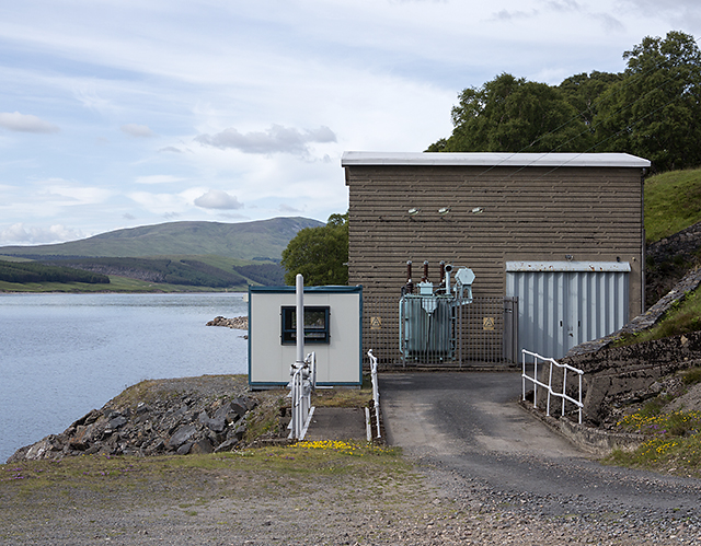
Power station near Corrievarkie Lodge The hydroelectric power station on the shore of Loch Ericht, approximately one kilometre north east of Corrievarkie Lodge.
Power station near Corrievarkie Lodge
The hydroelectric power station on the shore of Loch Ericht, approximately one kilometre north east of Corrievarkie Lodge.
Track in Coire Bhùirich A track in Coire Bhùirich leading from Loch Ericht towards the headwaters of the Allt a' Chumhainn. Corrievarkie Lodge can be seen in the distance.
Track in Coire Bhùirich
A track in Coire Bhùirich leading from Loch Ericht towards the headwaters of the Allt a' Chumhainn. Corrievarkie Lodge can be seen in the distance.
Coire Bhùirich The upper region of Coire Bhùirich, with the steep south-facing slopes of An Sgulan visible in the background.
Coire Bhùirich
The upper region of Coire Bhùirich, with the steep south-facing slopes of An Sgulan visible in the background.
Cùl an Aonaich Oidhir Moorland on the col between Cùl an Aonaich Oidhir and Creag Dhearg, near the headwaters of the Allt a' Chumhainn.
Cùl an Aonaich Oidhir
Moorland on the col between Cùl an Aonaich Oidhir and Creag Dhearg, near the headwaters of the Allt a' Chumhainn.
Moorland south of Cùl an Aonaich Oidhir Moorland at the col between Cùl an Aonaich Oidhir and Creag Dhearg, with Schiehallion visible in the distance.
Moorland south of Cùl an Aonaich Oidhir
Moorland at the col between Cùl an Aonaich Oidhir and Creag Dhearg, with Schiehallion visible in the distance.
Moorland by the Allt na Glaise Moorland and peat hags by the Allt na Glaise, 4km to the east of Loch Ericht. Schiehallion can be seen in the distance, a prominent landmark from many viewpoints in central Scotland.
Moorland by the Allt na Glaise
Moorland and peat hags by the Allt na Glaise, 4km to the east of Loch Ericht. Schiehallion can be seen in the distance, a prominent landmark from many viewpoints in central Scotland.
Allt na Glaise Peat-hagged moorland by the Allt na Glaise, viewed from the eastern slopes of Cùl an Aonaich Oidhir.
Allt na Glaise
Peat-hagged moorland by the Allt na Glaise, viewed from the eastern slopes of Cùl an Aonaich Oidhir.
Show me another place!

An Sgùlan is located at Grid Ref: NN5772 (Lat: 56.819273, Lng: -4.3439019)

Unitary Authority: Perth and Kinross

Police Authority: Tayside

What 3 Words

///insurance.groom.cleanser. Near Newtonmore, Highland

Nearby Locations

An Sgùlan

Related Wikis

Beinn Udlamain

Beinn Udlamain is a Scottish mountain which stands just to the west of the summit of the Pass of Drumochter and east of Loch Ericht, some 30 km west-northwest...

Sgairneach Mhòr

Sgairneach Mhòr is a Scottish mountain which lies in a group of seven Munros near the summit of the Pass of Drumochter and are known as the Drumochter...

Loch Ericht

Loch Ericht (Scottish Gaelic: Loch Eireachd) is a freshwater loch on the border between the former Perthshire, now Perth and Kinross and the former Inverness...

Stob an Aonaich Mhòir

Stob an Aonaich Mhoir (855 m) is a remote mountain in the Grampian Mountains of Scotland. It lies in Perthshire, on the eastern shore of Loch Ericht. Due...

Have you been to An Sgùlan?

Leave your review of An Sgùlan below (or comments, questions and feedback).