Hinxton

Settlement in Cambridgeshire South Cambridgeshire

England

Hinxton

Fields at Great Chesterford
Fields at Great Chesterford Credit: Terry Butcher

Hinxton is a small village located in Cambridgeshire, England. Situated approximately 10 miles south of Cambridge, the village is nestled on the banks of the River Cam. With a population of around 500 residents, Hinxton retains its rural charm while benefiting from its proximity to the bustling city.

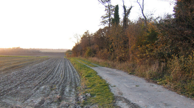
The village itself is known for its picturesque surroundings, characterized by rolling countryside, meadows, and beautiful river views. The area is home to many historic buildings, including the Grade I listed Hinxton Hall, a stunning manor house dating back to the 18th century. Adjacent to the hall is the world-renowned Wellcome Genome Campus, a leading scientific research center that focuses on genomics and computational biology.

Hinxton offers a range of amenities to its residents and visitors. The local primary school provides education for children in the village, while the village hall hosts various community events and activities throughout the year. There is also a charming village pub, The Red Lion, offering a warm and welcoming atmosphere for locals and tourists alike.

The village is well-connected to nearby towns and cities, with easy access to major transportation routes. The M11 motorway is just a short drive away, providing convenient links to London and the rest of the country. Additionally, the nearby Whittlesford Parkway railway station offers regular train services to Cambridge, London, and other destinations.

Overall, Hinxton is a delightful village that seamlessly combines the tranquility of rural life with the advantages of modern amenities and easy access to nearby urban centers.

If you have any feedback on the listing, please let us know in the comments section below.

Hinxton Images

Images are sourced within 2km of 52.086227/0.181127 or Grid Reference TL4945. Thanks to Geograph Open Source API. All images are credited.

Fields at Great Chesterford
Field Farm
Field Farm
Field Farm Cottages
Field Farm Cottages
Stump Cross Roundabout
Track and ploughed field South of Hinxton Grange at sunset.
Track and ploughed field
South of Hinxton Grange at sunset.
Field track beyond a little-used farm store at Hinxton Piles of beets surrounded by straw bales, a few empty farm buildings then this track heading nowhere.
Field track beyond a little-used farm store at Hinxton
Piles of beets surrounded by straw bales, a few empty farm buildings then this track heading nowhere.
Unused farm store near Hinxton
Road sign near Genome Campus On the A1301 near Stump Cross.
Road sign near Genome Campus
On the A1301 near Stump Cross.
A view of the end of Field Farm Drive at Stump Cross
Old Milestone Old milestone near to Hinxton, Cambridgeshire on the A1301. For close up view see <a title="https://www.geograph.org.uk/photo/1535062" href="https://www.geograph.org.uk/photo/1535062">Link</a>
Old Milestone
Old milestone near to Hinxton, Cambridgeshire on the A1301. For close up view see Link
Old Milestone Old milestone near to Hinxton, Cambridgeshire on the A1301. For overall view see <a title="https://www.geograph.org.uk/photo/1535043" href="https://www.geograph.org.uk/photo/1535043">Link</a>
Old Milestone
Old milestone near to Hinxton, Cambridgeshire on the A1301. For overall view see Link
A11 approaching the M11
Heading south on the A11
Turn off to the A1301, A11 The last junction before the M11.
Turn off to the A1301, A11
The last junction before the M11.
The start of the M11
Roundabout at Stump Cross The road in the distance is the slip road from the westbound A11
Roundabout at Stump Cross
The road in the distance is the slip road from the westbound A11
Roundabout at junction Newmarket and Walden Roads Southerly roundabout at Stumps Cross
Roundabout at junction Newmarket and Walden Roads
Southerly roundabout at Stumps Cross
Roundabout just south of Hinxton on A1301
Show me another place!

Hinxton is located at Grid Ref: TL4945 (Lat: 52.086227, Lng: 0.181127)

Administrative County: Cambridgeshire

District: South Cambridgeshire

Police Authority: Cambridgeshire

What 3 Words

///stood.prestige.wooden. Near Duxford, Cambridgeshire

Nearby Locations

Hinxton Hinxton

Related Wikis

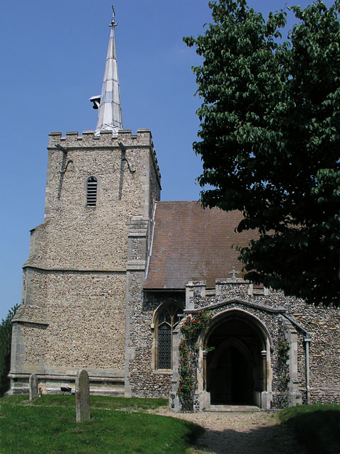
St Mary and St John Church, Hinxton

St Mary and St John Church is a Church of England parish church in the village of Hinxton in Cambridgeshire. It is a medieval flint and rubble church in...

Wellcome Genome Campus

The Wellcome Genome Campus is a scientific research campus built in the grounds of Hinxton Hall, Hinxton in Cambridgeshire, England. == Campus == The Campus...

Hinxton

Hinxton is a village in South Cambridgeshire, England. The River Cam runs through the village, as does the Cambridge to Liverpool Street railway, though...

Wellcome Sanger Institute

The Wellcome Sanger Institute, previously known as The Sanger Centre and Wellcome Trust Sanger Institute, is a non-profit British genomics and genetics...

Nearby Amenities

Located within 500m of 52.086227,0.181127
Source: npe
Lat/Long: 52.0878252/0.1744806
Source: npe
Lat/Long: 52.0871571/0.1753019
Source: npe
Lat/Long: 52.0867371/0.1747847
Source: npe
Lat/Long: 52.0857387/0.1752445
Source: npe
Lat/Long: 52.0855349/0.1763002
Source: npe
Lat/Long: 52.0841344/0.1788119
Source: npe
Lat/Long: 52.0832311/0.1783505
Source: npe
Lat/Long: 52.082374/0.177975
Hinxton
Is In: Cambridgeshire, England, UK
Place: village
Population: 315
Wikidata: Q2356502
Lat/Long: 52.0848693/0.1792608
Post Box
Collection Times: Mo-Fr 16:00; Sa 11:45
Operator: Royal Mail
Post Box Type: lamp
Ref: CB10 51
Royal Cypher: EIIR
Royal Cypher Wikidata: Q33102113
Source: survey
Lat/Long: 52.0873011/0.1800957
Post Box
Collection Times: Mo-Fr 09:00; Sa 07:00
Operator: Royal Mail
Post Box Type: lamp
Ref: CB10 50
Royal Cypher: EIIR
Royal Cypher Wikidata: Q33102113
Source: survey
Lat/Long: 52.0847208/0.1818304
Pub
Red Lion
Addr City: Saffron Walden
Addr Housenumber: 32
Addr Postcode: CB10 1QY
Addr Street: High Street
Addr Village: Hinxton
Email: info@redlionhinxton.co.uk
Phone: +44 1799 530 601
Website: https://redlionhinxton.co.uk/
Wikidata: Q26420952
Lat/Long: 52.0839352/0.1821939
Bus Stop
Church Green
Naptan AtcoCode: 0500SHINX001
Naptan Bearing: S
Naptan BusStopType: CUS
Naptan CommonName: Church Green
Naptan Indicator: near
Naptan Landmark: Church Green
Naptan NaptanCode: cmbdwtmd
Naptan Street: High Street
Naptan Verified: no
Source: naptan_import
Lat/Long: 52.0844083/0.1820611
Bus Stop
North End Road
Naptan AtcoCode: 0500SHINX002
Naptan Bearing: W
Naptan BusStopType: CUS
Naptan CommonName: North End Road
Naptan Indicator: opp No 23
Naptan Landmark: No 23
Naptan NaptanCode: cmbdwtmg
Naptan Street: North End Road
Naptan Verified: no
Source: naptan_import
Lat/Long: 52.0883066/0.1814345
Bus Stop
North End Road
Naptan AtcoCode: 0500SHINX003
Naptan Bearing: E
Naptan CommonName: North End Road
Naptan Indicator: o/s No 23
Naptan Landmark: No 23
Naptan NaptanCode: cmbdwtmj
Naptan Street: North End Road
Naptan Verified: no
Source: naptan_import
Lat/Long: 52.0884088/0.1813929
Bus Stop
New Road
Naptan AtcoCode: 0500SHINX004
Naptan Bearing: N
Naptan CommonName: New Road
Naptan Indicator: opp
Naptan Landmark: New Road
Naptan NaptanCode: cmbdwtmp
Naptan Street: High Street
Naptan Verified: no
Source: naptan_import
Lat/Long: 52.083117/0.1825944
Bus Stop
Church Green
Naptan AtcoCode: 0500SHINX005
Naptan Bearing: N
Naptan CommonName: Church Green
Naptan Indicator: opp
Naptan Landmark: Church Green
Naptan NaptanCode: cmbdwtmt
Naptan Street: High Street
Naptan Verified: no
Source: naptan_import
Lat/Long: 52.0843831/0.1819578
Bus Stop
New Road
Naptan AtcoCode: 0500SHINX006
Naptan Bearing: S
Naptan BusStopType: CUS
Naptan CommonName: New Road
Naptan Indicator: near
Naptan Landmark: New Road
Naptan NaptanCode: cmbdwtmw
Naptan Street: High Street
Naptan Verified: no
Source: naptan_import
Lat/Long: 52.08316/0.1826987
Power: pole
Lat/Long: 52.082137/0.1811828
Power: pole
Lat/Long: 52.0834325/0.1783802
Power: pole
Lat/Long: 52.0855338/0.1759018
Power: pole
Lat/Long: 52.0824335/0.1774361
Power: pole
Lat/Long: 52.0874836/0.1756256
Power: pole
Lat/Long: 52.0838215/0.1791229
Power: pole
Lat/Long: 52.0832214/0.1769345
Power: pole
Lat/Long: 52.0839846/0.1764705
Power: pole
Lat/Long: 52.0847971/0.1759903
Power: pole
Lat/Long: 52.0867655/0.1742032
Power: pole
Lat/Long: 52.081888/0.1795897
Power: pole
Lat/Long: 52.0828078/0.1771947
Power: pole
Lat/Long: 52.0866377/0.1757454
Power: pole
Lat/Long: 52.0872903/0.1770466
Power: pole
Lat/Long: 52.0868746/0.1773945
Hinxton Ford
Ford: yes
Lat/Long: 52.0864371/0.1751045
Entrance: yes
Lat/Long: 52.0839052/0.1822133
Fountain
Lat/Long: 52.0835895/0.1823735
Waterway: weir
Lat/Long: 52.0852612/0.1777794
Barrier: cycle_barrier
Cyclestreets Id: 107157
Mapillary: 314114753677955
Lat/Long: 52.0889941/0.1832607
Bench
Backrest: yes
Material: wood
Seats: 4
Lat/Long: 52.0846564/0.1833156
Bench
Backrest: yes
Material: wood
Seats: 4
Lat/Long: 52.0847311/0.1832526
Bench
Backrest: yes
Material: wood
Seats: 4
Lat/Long: 52.084651/0.182672
Bench
Backrest: yes
Material: wood
Seats: 4
Lat/Long: 52.0844917/0.181991
Public Bookcase
Hinxton Mini Library
Booth: K6
Disused Amenity: telephone
Listed Status: Grade II
Man Made: telephone_box
Public Bookcase Type: phone_box
Lat/Long: 52.0845288/0.1820383
Historic: memorial
Memorial: war_memorial
Lat/Long: 52.0845917/0.1819959
The data included in this document is from www.openstreetmap.org. The data is made available under ODbL.

Have you been to Hinxton?

Leave your review of Hinxton below (or comments, questions and feedback).