Brown Hill

Hill, Mountain in Ayrshire

Scotland

Brown Hill

Brown Hill A wide forest ride on the lower slopes of Brown Hill, near Dalmellington.  The cotton grass shows that even the slopes here are wet places.
Brown Hill Credit: Mary and Angus Hogg

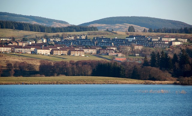
Brown Hill is a prominent natural feature located in Ayrshire, Scotland. It is classified as a hill, rather than a mountain, with an elevation of approximately 215 meters (705 feet) above sea level. The hill lies approximately 5 kilometers (3 miles) northeast of the town of Ayr and is part of the wider Ayrshire Hills range.

Brown Hill is characterized by its gently sloping sides and a distinct rounded summit. The hill is predominantly covered in grasses, heather, and scattered shrubs, with some areas of woodland on its lower slopes. The vegetation provides habitat for a variety of wildlife, including small mammals, birds, and insects.

The hill offers stunning panoramic views of the surrounding countryside and the nearby towns. On a clear day, visitors can see the Isle of Arran to the west and the rolling hills of Ayrshire to the east. The summit also provides an excellent vantage point for watching sunsets or observing local weather patterns.

Brown Hill is a popular destination for outdoor enthusiasts, walkers, and hikers due to its accessible location and relatively easy ascent. There are several well-defined paths and trails that lead to the summit, making it suitable for people of all fitness levels. Additionally, there is a small car park at the base of the hill, providing convenient access for visitors.

Overall, Brown Hill is a picturesque natural feature of Ayrshire, offering recreational opportunities, scenic views, and a chance to immerse oneself in the beauty of the Scottish countryside.

If you have any feedback on the listing, please let us know in the comments section below.

Brown Hill Images

Images are sourced within 2km of 55.311987/-4.3466134 or Grid Reference NS5104. Thanks to Geograph Open Source API. All images are credited.

Brown Hill A wide forest ride on the lower slopes of Brown Hill, near Dalmellington.  The cotton grass shows that even the slopes here are wet places.
Brown Hill
A wide forest ride on the lower slopes of Brown Hill, near Dalmellington. The cotton grass shows that even the slopes here are wet places.
Kyle Forest Road This road goes around Benbrack Hill in the Kyle Forest.
Kyle Forest Road
This road goes around Benbrack Hill in the Kyle Forest.
Benbrack Burn Looking down the valley of Benbrack Burn in the Kyle Forest.
Benbrack Burn
Looking down the valley of Benbrack Burn in the Kyle Forest.
Benbrack Burn Looking up the valley of Benbrack Burn in the Kyle Forest.
Benbrack Burn
Looking up the valley of Benbrack Burn in the Kyle Forest.
Kyle Forest Road This road goes around Chair Hill in the Kyle Forest.
Kyle Forest Road
This road goes around Chair Hill in the Kyle Forest.
Shiel Burn View Looking towards the open space in Kyle Forest alongside Shiel Burn.
Shiel Burn View
Looking towards the open space in Kyle Forest alongside Shiel Burn.
Shiel Burn Bridge The forestry road comes to an end shortly after this bridge.
Shiel Burn Bridge
The forestry road comes to an end shortly after this bridge.
Sheepfold by Shiel Burn The hill grazing land would have been abandoned when the forests were planted, but  these dry-stane enclosures were built to last.
Sheepfold by Shiel Burn
The hill grazing land would have been abandoned when the forests were planted, but these dry-stane enclosures were built to last.
Brown Hill View Looking down the wide forest ride towards the derelict sheepfold beside Shiel Burn.
Brown Hill View
Looking down the wide forest ride towards the derelict sheepfold beside Shiel Burn.
Shiel Burn View An upstream view of this burn which tumbles its way down from Harthorn Hill.
Shiel Burn View
An upstream view of this burn which tumbles its way down from Harthorn Hill.
Black Burn An upstream view of this burn which tumbles its way down from Black Rigg in the Kyle Forest.
Black Burn
An upstream view of this burn which tumbles its way down from Black Rigg in the Kyle Forest.
Shiel Burn View An upstream view of this burn which tumbles its way down from Harthorn Hill.
Shiel Burn View
An upstream view of this burn which tumbles its way down from Harthorn Hill.
Shiel Burn A downstream view of this burn which tumbles its way down from Harthorn Hill.
Shiel Burn
A downstream view of this burn which tumbles its way down from Harthorn Hill.
Old Milestone by the A713, above Muck Water, Dalmellington Parish By the A713, in parish of Dalmellington (Kyle District), North of Carsphairn, downhill towards Dalmellington, on narrow verge at side of road above Muck Water.

Inscription reads:- : (?) / 21 / D(almellington) / 1¾ : : Carsphain / 7¼ : 

Surveyed

Milestone Society National ID: AYE_AYNG18.
Old Milestone by the A713, above Muck Water, Dalmellington Parish
By the A713, in parish of Dalmellington (Kyle District), North of Carsphairn, downhill towards Dalmellington, on narrow verge at side of road above Muck Water. Inscription reads:- : (?) / 21 / D(almellington) / 1¾ : : Carsphain / 7¼ : Surveyed Milestone Society National ID: AYE_AYNG18.
Muck Water Below the broken crags of Meikle Craigwaughton.
Muck Water
Below the broken crags of Meikle Craigwaughton.
Clear felled area in Glen Muck There is some rugged ground to the south of Dalmellington.
Clear felled area in Glen Muck
There is some rugged ground to the south of Dalmellington.
A713, Glen Muck In a narrow glen, the road has not been improved here. It is much wider and better aligned further south.
A713, Glen Muck
In a narrow glen, the road has not been improved here. It is much wider and better aligned further south.
A713, Glen Muck In a narrow glen, the road has not been improved here. It is much wider and better aligned further south.
A713, Glen Muck
In a narrow glen, the road has not been improved here. It is much wider and better aligned further south.
Show me another place!

Brown Hill is located at Grid Ref: NS5104 (Lat: 55.311987, Lng: -4.3466134)

Unitary Authority: East Ayrshire

Police Authority: Ayrshire

What 3 Words

///ordeals.tablets.loosens. Near Bellsbank, East Ayrshire

Nearby Locations

Brown Hill

Related Wikis

Bellsbank

Bellsbank is a village half a mile away from the market town of Dalmellington in East Ayrshire, Scotland. It is the second-highest place in East Ayrshire...

Dalmellington

Dalmellington (Scots: Dawmellinton, Scottish Gaelic: Dail M'Fhaolain) is a market town and civil parish in East Ayrshire, Scotland. In 2001 the village...

Dalmellington railway station

Dalmellington railway station served the town of Dalmellington, East Ayrshire, Scotland, from 1856 to 1964 on the Ayr and Dalmellington Railway. ��2�...

Doon Academy

Doon Academy is a secondary school in Dalmellington that caters to the local surrounding areas Dalmellington, Patna, Rankinston and Bellsbank. The current...

Have you been to Brown Hill?

Leave your review of Brown Hill below (or comments, questions and feedback).