Cairnsmore of Fleet

Hill, Mountain in Kirkcudbrightshire

Scotland

Cairnsmore of Fleet

Ridge descending to Nick of Clashneach The broad grassy ridge has descended from Cairnsmore of Fleet. The Nick of Clashneach is the col between Cairnsmore and the hill in the image which is known as Knee of Cairnsmore.
Ridge descending to Nick of Clashneach Credit: Trevor Littlewood

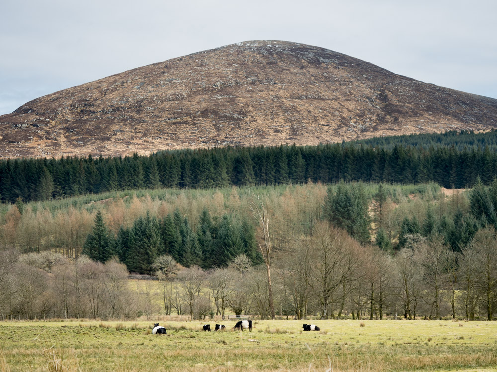
Cairnsmore of Fleet is a prominent hill located in the region of Kirkcudbrightshire, Dumfries and Galloway, in southwestern Scotland. Standing at an impressive height of 711 meters (2,333 feet), it is one of the highest hills in the area and offers stunning panoramic views of the surrounding landscape.

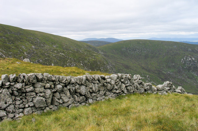
The hill is part of the Galloway Forest Park, a vast and picturesque area known for its diverse flora and fauna. Cairnsmore of Fleet is characterized by its rugged terrain, with steep slopes and rocky outcrops that provide a challenging yet rewarding climb for outdoor enthusiasts.

The hill is renowned for its rich biodiversity, with a variety of plant species and wildlife inhabiting its slopes. The hillside is covered in heather and scattered with patches of woodland, creating a vibrant and colorful landscape, particularly during the summer months.

At the summit of Cairnsmore of Fleet, a trig point marks the highest point, allowing visitors to take in the breathtaking views of the surrounding hills, lochs, and forests. On clear days, it is possible to see as far as the Isle of Man and the Lake District in England.

The hill is a popular destination for hikers and nature lovers, with several well-marked trails leading to the summit. It is also home to a variety of bird species, including peregrine falcons, buzzards, and golden eagles, making it a haven for birdwatchers.

Overall, Cairnsmore of Fleet is a magnificent natural landmark in Kirkcudbrightshire, offering a unique and memorable experience for those who venture to its summit.

If you have any feedback on the listing, please let us know in the comments section below.

Cairnsmore of Fleet Images

Images are sourced within 2km of 54.975684/-4.3427179 or Grid Reference NX5067. Thanks to Geograph Open Source API. All images are credited.

Ridge descending to Nick of Clashneach The broad grassy ridge has descended from Cairnsmore of Fleet. The Nick of Clashneach is the col between Cairnsmore and the hill in the image which is known as Knee of Cairnsmore.
Ridge descending to Nick of Clashneach
The broad grassy ridge has descended from Cairnsmore of Fleet. The Nick of Clashneach is the col between Cairnsmore and the hill in the image which is known as Knee of Cairnsmore.
Cairnsmore from above Creetown April snow contributes to a picturesque scene.
Cairnsmore from above Creetown
April snow contributes to a picturesque scene.
Path on Cairnsmore of Fleet The path from Cairnsmore farm at about 650m; not far to go to the summit and a good viewpoint for the Cree estuary.
Path on Cairnsmore of Fleet
The path from Cairnsmore farm at about 650m; not far to go to the summit and a good viewpoint for the Cree estuary.
Cairnsmore of Fleet summit cairn and air crash memorial The memorial commemorates air crew, many of them only late teens and early 20s, killed in crashes during WWII and some later accidents. More details are given in Andy Farrington's photograph <a href="https://www.geograph.org.uk/photo/2246866">NX5067 : Memorial on the Cairnsmore of Fleet</a>.

The cairn sits on a slightly raised point to the SW of the trig pillar (711m).
Cairnsmore of Fleet summit cairn and air crash memorial
The memorial commemorates air crew, many of them only late teens and early 20s, killed in crashes during WWII and some later accidents. More details are given in Andy Farrington's photograph NX5067 : Memorial on the Cairnsmore of Fleet. The cairn sits on a slightly raised point to the SW of the trig pillar (711m).
Cairnsmore of Fleet summit trig pillar The trig pillar and drystane shelter seen from the summit cairn.
Cairnsmore of Fleet summit trig pillar
The trig pillar and drystane shelter seen from the summit cairn.
North from the summit cairn, Cairnsmore of Fleet Looking towards the hills north of Glen Trool, culminating in The Merrick (843m), the highest hill in Galloway.
North from the summit cairn, Cairnsmore of Fleet
Looking towards the hills north of Glen Trool, culminating in The Merrick (843m), the highest hill in Galloway.
Eastern slopes of Cairnsmore of Fleet An old fence runs along the ridge below the summit to the Nick of the Saddle and on to Meikle Mulltaggart, the sunlit slope R of centre. Part of Clatteringshaws Loch is in the distance.
Eastern slopes of Cairnsmore of Fleet
An old fence runs along the ridge below the summit to the Nick of the Saddle and on to Meikle Mulltaggart, the sunlit slope R of centre. Part of Clatteringshaws Loch is in the distance.
Knee of Cairnsmore The summit of the Knee of Cairnsmore seen from the fence SE of the main top.
Knee of Cairnsmore
The summit of the Knee of Cairnsmore seen from the fence SE of the main top.
Trig point on Cairnsmore of Fleet The rather damaged trig point at the summit of Cairnsmore of Fleet has flush bracket No. S1561.
The hills in the distance lie west of north with Merrick being most prominent.
Trig point on Cairnsmore of Fleet
The rather damaged trig point at the summit of Cairnsmore of Fleet has flush bracket No. S1561. The hills in the distance lie west of north with Merrick being most prominent.
Dry stone wall at Nick of Clashneach The Nick of Clashneach is a col south-south-east of the summit of Cairnsmore of Fleet. The vast eastern side of the mountain is partly in view with the feature, Clints of the Spout, to be seen centrally above the wall.
Dry stone wall at Nick of Clashneach
The Nick of Clashneach is a col south-south-east of the summit of Cairnsmore of Fleet. The vast eastern side of the mountain is partly in view with the feature, Clints of the Spout, to be seen centrally above the wall.
Cairnsmore of Fleet Trig point
Cairnsmore of Fleet Path With Wigtown Bay in the distance.
Cairnsmore of Fleet Path
With Wigtown Bay in the distance.
The grassy summit of Cairnsmore of Fleet with a view towards Merrick
The eastern slopes of Cairnsmore of Fleet from the Knee of Cairnsmore
Nick of Clashneach. Saddle on the summit ridge of Cairnsmore of Fleet, looking north to the main summit.
Nick of Clashneach.
Saddle on the summit ridge of Cairnsmore of Fleet, looking north to the main summit.
the summit cairn on Cairnsmore of Fleet
the gentle summit ridge of Cairnsmore of Fleet In the 1920's and 1930's aeroplanes would land on this ridge, bringing guests to and from Cairnsmore House.  The track, shown here, was built so that ponies could carry guests and their luggage up and down the hill.  The summit cairn can be seen in the distance.
the gentle summit ridge of Cairnsmore of Fleet
In the 1920's and 1930's aeroplanes would land on this ridge, bringing guests to and from Cairnsmore House. The track, shown here, was built so that ponies could carry guests and their luggage up and down the hill. The summit cairn can be seen in the distance.
The summit of Cairnsmore of Fleet 711 metres. The triangulation point and old shelter on the summit of Cairnsmore of Fleet near Palnure, Newton Stewart.
The summit of Cairnsmore of Fleet 711 metres.
The triangulation point and old shelter on the summit of Cairnsmore of Fleet near Palnure, Newton Stewart.
Show me another place!

Cairnsmore of Fleet is located at Grid Ref: NX5067 (Lat: 54.975684, Lng: -4.3427179)

Unitary Authority: Dumfries and Galloway

Police Authority: Dumfries and Galloway

What 3 Words

///inspector.licks.woes. Near Newton Stewart, Dumfries & Galloway

Nearby Locations

Cairnsmore of Fleet

Related Wikis

Cairnsmore of Fleet

Cairnsmore of Fleet is an isolated mountain in the Southern Uplands of Scotland. The mountain forms an unafforested granite massif, whose highest point...

Talnotrie Hoard

The Talnotrie Hoard is a 9th-century mixed hoard of jewellery, coinage, metal-working objects and raw materials found in Talnotrie, Scotland, in 1912....

Kirroughtree

Kirroughtree Forest is located near Newton Stewart in Dumfries and Galloway, southwest Scotland and overlooks the Irish Sea. It is managed by Forestry...

Palnure railway station

Palnure railway station (NX450634) was a railway station on the Portpatrick and Wigtownshire Joint Railway close to Newton Stewart and the junction for...

Nearby Amenities

Located within 500m of 54.975684,-4.3427179
Cairnsmore of Fleet
Ele: 711
Natural: peak
Wikidata: Q5017736
Wikipedia: en:Cairnsmore of Fleet
Lat/Long: 54.9757604/-4.3427327
RAF memorial
Historic: memorial
Lat/Long: 54.9752366/-4.3427558
Man Made: cairn
Lat/Long: 54.9754678/-4.3432974
Shelter
Lat/Long: 54.9756456/-4.3428086
Man Made: survey_point
Lat/Long: 54.9757013/-4.3427003
The data included in this document is from www.openstreetmap.org. The data is made available under ODbL.

Have you been to Cairnsmore of Fleet?

Leave your review of Cairnsmore of Fleet below (or comments, questions and feedback).