Bryn-llidiard

Hill, Mountain in Caernarfonshire

Wales

Bryn-llidiard

Cors y Llyn
Cors y Llyn Credit: Chris Andrews

Bryn-llidiard is a prominent hill/mountain located in the region of Caernarfonshire in North Wales. Standing at an elevation of approximately 486 meters (1,594 feet), it is a notable landmark within the Snowdonia National Park.

The hill/mountain is situated about 5 kilometers south of the town of Caernarfon and offers breathtaking panoramic views of the surrounding countryside, including the Menai Strait and the Isle of Anglesey. Its location within the national park makes it a popular destination for hikers, nature enthusiasts, and photographers who are drawn to its natural beauty.

Bryn-llidiard boasts a diverse and rich ecosystem, supporting a variety of plant and animal species. The hill/mountain is adorned with lush greenery, including heather, gorse, and grasses, creating a picturesque landscape. It is also home to several species of birds, such as the red kite, peregrine falcon, and buzzard, making it a haven for birdwatchers.

The hill/mountain offers various walking and hiking trails, catering to different levels of difficulty and experience. The paths are well-maintained and signposted, ensuring visitors can explore and navigate the area safely. The summit of Bryn-llidiard provides an excellent vantage point for capturing breathtaking views and offers a rewarding sense of achievement upon reaching the top.

Bryn-llidiard is not only a natural gem but also holds historical significance. It is believed that the hill/mountain has been a site of human activity for thousands of years, with archaeological remains suggesting habitation during the Iron Age. Exploring the area provides an opportunity to connect with Wales' ancient past and its captivating natural wonders.

If you have any feedback on the listing, please let us know in the comments section below.

Bryn-llidiard Images

Images are sourced within 2km of 53.043941/-4.2432796 or Grid Reference SH4951. Thanks to Geograph Open Source API. All images are credited.

Cors y Llyn
Cors y Llyn
Stench pipe, Talysarn
Remains of a guidepost, Talysarn
Minor road junction east of Llanllyfni
Rural road to Talysarn
Looking north towards Talysarn The long main street of former slate workers' cottages is clearly visible.
Looking north towards Talysarn
The long main street of former slate workers' cottages is clearly visible.
Desolate landscape to the east of Llanllyfni Decaying dry stone walls and ruined farmsteads...
Desolate landscape to the east of Llanllyfni
Decaying dry stone walls and ruined farmsteads...
The road to Llynnau Cwm Silyn (looks like rain) In fact, the rain held off although it was exceedingly gloomy.  Compare the picture taken by Jonathan Wilkins at almost the same spot in very different weather... <a title="https://www.geograph.org.uk/photo/5869406" href="https://www.geograph.org.uk/photo/5869406">Link</a>  .
The road to Llynnau Cwm Silyn (looks like rain)
In fact, the rain held off although it was exceedingly gloomy. Compare the picture taken by Jonathan Wilkins at almost the same spot in very different weather... Link .
Ruined farmstead under gloomy skies
Ruin of Maen-y-Gaseg The roof has collapsed since Eric Jones took a similar picture in 2006: <a title="https://www.geograph.org.uk/photo/251176" href="https://www.geograph.org.uk/photo/251176">Link</a> .
Ruin of Maen-y-Gaseg
The roof has collapsed since Eric Jones took a similar picture in 2006: Link .
Sheep under ominous skies The rain held off, despite the mist and low cloud blowing over the 700 metre summit of Garnedd Goch.
Sheep under ominous skies
The rain held off, despite the mist and low cloud blowing over the 700 metre summit of Garnedd Goch.
End of the road... ...and start of the track to Llynnau Cwm Silyn.    The Cwm is partly visible to the left in the background.
End of the road...
...and start of the track to Llynnau Cwm Silyn. The Cwm is partly visible to the left in the background.
Track over the moor to Cwm Silyn
looking north over the moors... ...with the peak of Mynydd y Cilgwyn in the distance, which is part of the Padarn tuff formation, being igneous bedrock formed between 635 and 541 million years ago during the Ediacaran period.
looking north over the moors...
...with the peak of Mynydd y Cilgwyn in the distance, which is part of the Padarn tuff formation, being igneous bedrock formed between 635 and 541 million years ago during the Ediacaran period.
Looking up towards Garnedd Goch The structure to the right of the wall in the middle-distance is the remains of a "16-celled sheep fold" according to Coflein listing 288176: <span class="nowrap"><a title="https://coflein.gov.uk/cy/safle/288176/" rel="nofollow ugc noopener" href="https://coflein.gov.uk/cy/safle/288176/">Link</a><img style="margin-left:2px;" alt="External link" title="External link - shift click to open in new window" src="https://s1.geograph.org.uk/img/external.png" width="10" height="10"/></span> .
Looking up towards Garnedd Goch
The structure to the right of the wall in the middle-distance is the remains of a "16-celled sheep fold" according to Coflein listing 288176: LinkExternal link .
The last house on the way to Cwm Silyn The road turns into a track a couple of hundred metres past the house.
The last house on the way to Cwm Silyn
The road turns into a track a couple of hundred metres past the house.
Upland sheep... ...with Cwm Silyn and Garnedd Goch looming in the background.
Upland sheep...
...with Cwm Silyn and Garnedd Goch looming in the background.
Upland scene east of Llanllyfni There are countless dry stone walls falling into ruin and abandoned farmsteads.
Upland scene east of Llanllyfni
There are countless dry stone walls falling into ruin and abandoned farmsteads.
Show me another place!

Bryn-llidiard is located at Grid Ref: SH4951 (Lat: 53.043941, Lng: -4.2432796)

Unitary Authority: Gwynedd

Police Authority: North Wales

What 3 Words

///carpeted.surprise.headboard. Near Talysarn, Gwynedd

Nearby Locations

Bryn-llidiard

Related Wikis

Talysarn

Tal-y-sarn () is a village in the slate quarrying Nantlle Valley in Gwynedd, Wales, next to Penygroes. It is part of the community of Llanllyfni and includes...

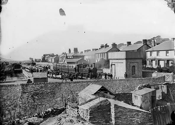
Nantlle railway station

Nantlle was a railway station located in Talysarn, a neighbouring village to Nantlle, in Gwynedd, Wales. From 1828 the narrow gauge, horse-drawn Nantlle...

Nantlle

Nantlle () is a small village in the slate quarrying Nantlle Valley in Gwynedd, Wales. It lies on the north shore of Llyn Nantlle Uchaf and is part of...
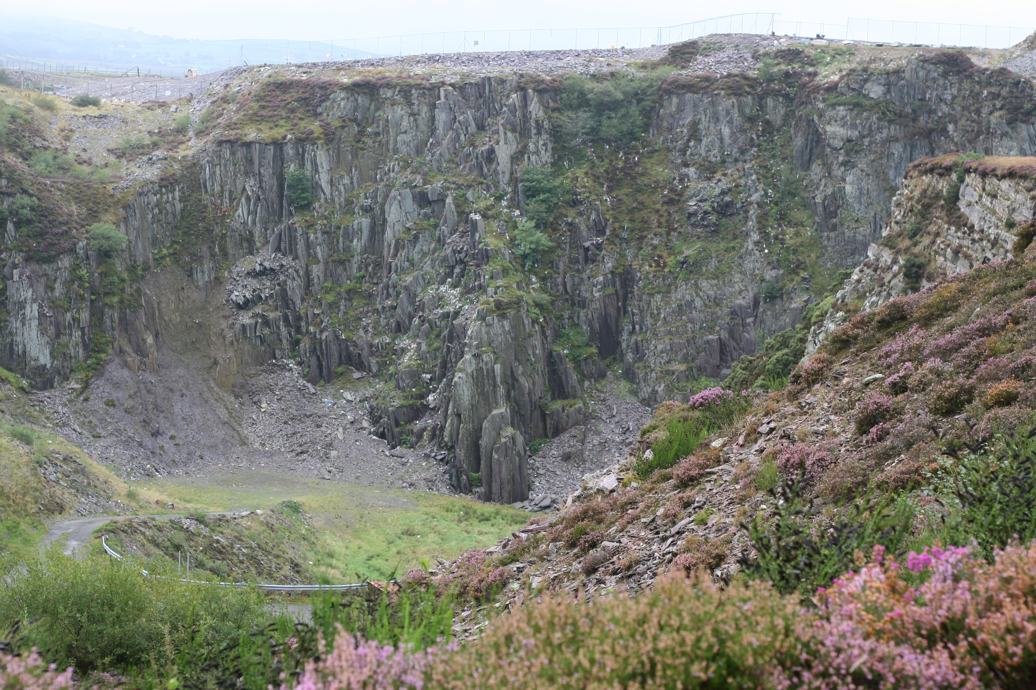
Cilgwyn quarry

Cilgwyn quarry is a slate quarry located on the north edge of the Nantlle Vale, in North Wales. It is one of the earliest slate quarries in Great Britain...

Nearby Amenities

Located within 500m of 53.043941,-4.2432796
Power: pole
Lat/Long: 53.0398245/-4.2438046
Power: pole
Lat/Long: 53.0404886/-4.2415218
Power: pole
Lat/Long: 53.0413852/-4.2385338
Power: pole
Lat/Long: 53.04021/-4.2424796
Power: pole
Lat/Long: 53.0407857/-4.2405511
The data included in this document is from www.openstreetmap.org. The data is made available under ODbL.

Have you been to Bryn-llidiard?

Leave your review of Bryn-llidiard below (or comments, questions and feedback).