Carswell Hill

Hill, Mountain in Renfrewshire

Scotland

Carswell Hill

Minor road,Moyne Moor Road cuts through very rough grazing near Picketlaw Farm
Minor road,Moyne Moor Credit: wfmillar

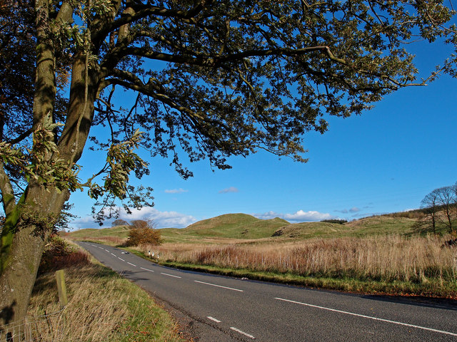
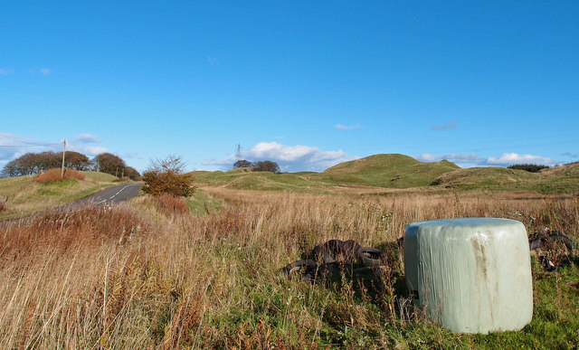
Carswell Hill is a prominent hill located in the county of Renfrewshire, Scotland. Rising to an impressive height of 348 meters (1,142 feet), it is situated in the southern part of the county, near the village of Howwood. The hill is a prominent feature of the local landscape and offers breathtaking panoramic views of the surrounding countryside.

Carswell Hill is part of the larger Gleniffer Braes Country Park, which spans over 480 hectares and is a popular destination for outdoor enthusiasts, hikers, and nature lovers. The park is home to diverse flora and fauna, with several well-marked trails leading to the summit of Carswell Hill.

The hill itself is characterized by its steep slopes, covered in heather and grasses, making it a challenging but rewarding climb for visitors. On a clear day, those who make the ascent are treated to stunning vistas that stretch as far as the eye can see, encompassing the rolling hills, forests, and farmland of Renfrewshire and beyond.

Carswell Hill also holds historical significance, serving as a site of an Iron Age fort in ancient times. The remains of this fort can still be seen today, adding an extra layer of intrigue to the hill's allure.

Overall, Carswell Hill is an excellent destination for those seeking a memorable outdoor experience, offering both natural beauty and a glimpse into the historical past of Renfrewshire.

If you have any feedback on the listing, please let us know in the comments section below.

Carswell Hill Images

Images are sourced within 2km of 55.747487/-4.4487576 or Grid Reference NS4653. Thanks to Geograph Open Source API. All images are credited.

Minor road,Moyne Moor Road cuts through very rough grazing near Picketlaw Farm
Minor road,Moyne Moor
Road cuts through very rough grazing near Picketlaw Farm
Carswell Hill View from minor road across sheep grazing fields.
Carswell Hill
View from minor road across sheep grazing fields.
Sheep Grazing Fields View over Carswell Farm to the mountains. Ben Lomond above the gate.
Sheep Grazing Fields
View over Carswell Farm to the mountains. Ben Lomond above the gate.
Moyne Moor Telephoto view over Moyne Farm (bottom right) to the snow covered mountains. Tallest in centre being Stob Bennein with Stob Coire an Lochain front right of it. Approximately 71Km away from photographers position.
Moyne Moor
Telephoto view over Moyne Farm (bottom right) to the snow covered mountains. Tallest in centre being Stob Bennein with Stob Coire an Lochain front right of it. Approximately 71Km away from photographers position.
Moyne Moor Driffenbeg Farm and the large Whitelee wind farm at Eagelsham Moor.
Moyne Moor
Driffenbeg Farm and the large Whitelee wind farm at Eagelsham Moor.
Minor Road, between Uplawmoor and Neilston Oak tree and Dareduff Hill.
Minor Road, between Uplawmoor and Neilston
Oak tree and Dareduff Hill.
Isolated Big Bale Adjacent to the minor road between Uplawmoor and Neilston. Dareduff Hill in the distance.
Isolated Big Bale
Adjacent to the minor road between Uplawmoor and Neilston. Dareduff Hill in the distance.
Path round Craighall Dam Walkers can circle Craighall Dam on a path of varying quality. Here the path, crossing the bottom of the picture, turns the corner at the south-west corner of the Dam having come through the gap between the two groups of trees.
Path round Craighall Dam
Walkers can circle Craighall Dam on a path of varying quality. Here the path, crossing the bottom of the picture, turns the corner at the south-west corner of the Dam having come through the gap between the two groups of trees.
Bench beside Craighall Dam Originally the bench enjoyed a fine view over Craighall Dam but the trees planted in front of it have grown and the loch is now hidden. It can be glimpsed looking back along the path in <a href="https://www.geograph.org.uk/photo/2878797">NS4654 : Path round Craighall Dam</a>.
Bench beside Craighall Dam
Originally the bench enjoyed a fine view over Craighall Dam but the trees planted in front of it have grown and the loch is now hidden. It can be glimpsed looking back along the path in NS4654 : Path round Craighall Dam.
Reeds on the edge of Craighall Dam
Craighall Dam from the southwest
Woodland path around Neilston Pad
Craighall Dam
Craighall Dam
Commore Dam Commore Dam is used for private fishing for various types of trout. Also in the photograph is the Commore Bridge which spans the Levern Water which in turn flows through Commore Dam.
Commore Dam
Commore Dam is used for private fishing for various types of trout. Also in the photograph is the Commore Bridge which spans the Levern Water which in turn flows through Commore Dam.
Farmland at Nether Carswell With the inevitable windmills on the horizon.
Farmland at Nether Carswell
With the inevitable windmills on the horizon.
Bridge over the Levern Water On a minor road north of Commore Dam.
Bridge over the Levern Water
On a minor road north of Commore Dam.
Knockenae Plantation With 2 windmills beyond the plantation.
Knockenae Plantation
With 2 windmills beyond the plantation.
Bend in road behind Uplawmoor Looking towards the Knockenae Plantation.
Bend in road behind Uplawmoor
Looking towards the Knockenae Plantation.
Show me another place!

Carswell Hill is located at Grid Ref: NS4653 (Lat: 55.747487, Lng: -4.4487576)

Unitary Authority: East Renfrewshire

Police Authority: Greater Glasgow

What 3 Words

///sway.dome.spearhead. Near Neilston, East Renfrewshire

Nearby Locations

Carswell Hill

Related Wikis

Craighall Reservoir

Craighall Reservoir, known locally as Craighall Dam, is one of a number of small reservoirs, situated around Neilston in East Renfrewshire, Scotland. The...

Neilston Pad

Neilston Pad, referred to locally as The Pad, is a distinctive hill in East Renfrewshire, situated a mile (1.5 km) south of the village of Neilston. Its...

Uplawmoor (L&A) railway station

Uplawmoor railway station was a railway station serving the village of Uplawmoor, East Renfrewshire, Scotland as part of the Lanarkshire and Ayrshire Railway...

Shillford

Shillford or Shilford is a hamlet to the south-west of Barrhead on the Lochlibo Road in East Renfrewshire near Uplawmoor, Scotland in the parish of Neilston...

Uplawmoor

Uplawmoor is a village in East Renfrewshire, Scotland. Its population was 700 as of 2016. Historic Uplawmoor, associated for centuries with the Barony...

Lands of Blacklaw

The Lands of Blacklaw formed a small property of five merks worth, in the Lordship of Stewarton at the eastern extremity of Strathannick, between the hamlet...

Loch Libo

Loch Libo is a freshwater loch in East Renfrewshire, Parish of Neilston, Scotland. The Lugton Water has its source from the southern end of loch, running...

Neilston F.C.

Neilston Football Club are a Scottish football club based in Neilston, East Renfrewshire who currently play in the West of Scotland League First Division...

Nearby Amenities

Located within 500m of 55.747487,-4.4487576
Nether Carswell
Place: locality
Lat/Long: 55.7506159/-4.4498764
Carswell Hill
Natural: peak
Lat/Long: 55.7477374/-4.4491608
Power: pole
Lat/Long: 55.7502532/-4.4431966
Power: pole
Lat/Long: 55.7494909/-4.4435179
Power: pole
Lat/Long: 55.7487227/-4.4438265
Power: pole
Lat/Long: 55.7480204/-4.4441085
Power: pole
Lat/Long: 55.7473263/-4.4443631
Power: pole
Lat/Long: 55.7466274/-4.4446657
Power: pole
Lat/Long: 55.7458404/-4.444674
Power: pole
Lat/Long: 55.7450992/-4.4446761
Power: pole
Lat/Long: 55.7443839/-4.4446886
Power: pole
Lat/Long: 55.7438306/-4.4446866
Power: pole
Lat/Long: 55.7502996/-4.4491336
Power: pole
Lat/Long: 55.7498034/-4.4474297
Power: pole
Lat/Long: 55.7494287/-4.4461672
Power: pole
Lat/Long: 55.7490893/-4.4450382
Power: pole
Lat/Long: 55.7483775/-4.4426561
Power: pole
Lat/Long: 55.7480146/-4.4414645
The data included in this document is from www.openstreetmap.org. The data is made available under ODbL.

Have you been to Carswell Hill?

Leave your review of Carswell Hill below (or comments, questions and feedback).