Meall Còs Chàrnan

Hill, Mountain in Inverness-shire

Scotland

Meall Còs Chàrnan

Allt Cam and track Near the ruins at Lùbvan. Looking towards Meall Còs Chàrnan.
Allt Cam and track Credit: wrobison

Meall Còs Chàrnan is a hill located in the Inverness-shire region of Scotland. Standing at a height of 528 meters (1,732 feet), it is classified as a Corbett, which refers to a Scottish hill between 2,500 and 3,000 feet in height.

Meall Còs Chàrnan is situated near the village of Kingussie and offers stunning panoramic views of the surrounding countryside. The hill is popular among hikers and outdoor enthusiasts for its relatively gentle slopes and well-defined trails, making it accessible to a wide range of skill levels.

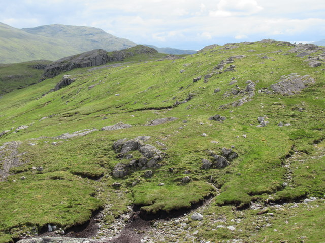
The terrain of Meall Còs Chàrnan is characterized by heather-covered slopes and rocky outcrops, which add to the natural beauty of the area. The hill is also home to a variety of wildlife, including red deer, mountain hares, and a diverse range of bird species.

Visitors to Meall Còs Chàrnan can enjoy a peaceful and tranquil environment, far away from the hustle and bustle of city life. Whether you are looking for a challenging hike or a leisurely stroll, Meall Còs Chàrnan offers a scenic and rewarding outdoor experience for all who visit.

If you have any feedback on the listing, please let us know in the comments section below.

Meall Còs Chàrnan Images

Images are sourced within 2km of 56.861722/-4.5718325 or Grid Reference NN4377. Thanks to Geograph Open Source API. All images are credited.

Allt Cam and track Near the ruins at Lùbvan. Looking towards Meall Còs Chàrnan.
Allt Cam and track
Near the ruins at Lùbvan. Looking towards Meall Còs Chàrnan.
The summit area of Meall Cos Charnan Looking north-east along the "twin" loch Lochan na h-Earba. The twin peaks of Binnein Shuas and Binnein Shios are to the left. For brief details of a proposed pumped hydro scheme here, see <a href="https://www.geograph.org.uk/photo/7480076">NN4681 : Lochan na h-Earba from the south-west</a>.
The summit area of Meall Cos Charnan
Looking north-east along the "twin" loch Lochan na h-Earba. The twin peaks of Binnein Shuas and Binnein Shios are to the left. For brief details of a proposed pumped hydro scheme here, see NN4681 : Lochan na h-Earba from the south-west.
East of the Abhainn Ghuilbinn Peat and heather moor on the gentle lower slopes of the valley drained by the Abhainn Ghuilbinn. Corrour Forest plantations are on the opposite side.
East of the Abhainn Ghuilbinn
Peat and heather moor on the gentle lower slopes of the valley drained by the Abhainn Ghuilbinn. Corrour Forest plantations are on the opposite side.
Allt Gualainn a' Charra Mhoir Still flowing fairly well despite the recent dry spell, as this burn is fed by snow patches lingering on the N side of Beinn Eibhinn. Loch Ghuilbinn is in view beyond.
Allt Gualainn a' Charra Mhoir
Still flowing fairly well despite the recent dry spell, as this burn is fed by snow patches lingering on the N side of Beinn Eibhinn. Loch Ghuilbinn is in view beyond.
Cairn on Ruigh Raonuill A cairn at the S end of this low ridge; looking through the glen of An Lairig between Beinn a' Chlachair on the left and Gael-Charn to the right. The nearer crag is on the end of the spur from Meall Nathrach.
Cairn on Ruigh Raonuill
A cairn at the S end of this low ridge; looking through the glen of An Lairig between Beinn a' Chlachair on the left and Gael-Charn to the right. The nearer crag is on the end of the spur from Meall Nathrach.
Bouldery slope west of Ruigh Raonuill The low hill within Corrour Forest plantation is Meall Luidh Mor. In the background, L to R is Beinn a' Chaorainn, the ridge sweeping up to Creag Meagaidh and An Cearcallach.
Bouldery slope west of Ruigh Raonuill
The low hill within Corrour Forest plantation is Meall Luidh Mor. In the background, L to R is Beinn a' Chaorainn, the ridge sweeping up to Creag Meagaidh and An Cearcallach.
Ruin by the Allt Gualainn a' Charra Mhoir Remains of what was probably a shieling close to the burn.
Ruin by the Allt Gualainn a' Charra Mhoir
Remains of what was probably a shieling close to the burn.
Allt Cam
Allt Cam
Path alongside Allt Cam at western end of Beinn a' Chlachair
Common Lizard - western end of Beinn a' Chlachair
View north-east from ridge on Meall Cos Charnan above Glen Spean
Summit of Meall Cos Charnan above Glen Spean The clump of rock that buttresses the summit has a presence that my photo could not capture.
Summit of Meall Cos Charnan above Glen Spean
The clump of rock that buttresses the summit has a presence that my photo could not capture.
Apron of land between Abhainn Ghuilbinn and Meall Cos Charnan above Glen Spean
Last act as a free river for Allt Cam above Glen Spean
Looking upstream on Allt Cam above Glen Spean
Looking downstream on Allt Cam above Glen Spean
Tiny tributary trickles into Allt Cam above Glen Spean
Rough boggy grassland west of Allt Cam above Glen Spean
Show me another place!

Meall Còs Chàrnan is located at Grid Ref: NN4377 (Lat: 56.861722, Lng: -4.5718325)

Unitary Authority: Highland

Police Authority: Highlands and Islands

What 3 Words

///deferring.pepper.skyrocket. Near Gairlochy, Highland

Related Wikis

Beinn a' Chlachair

Beinn a' Chlachair (1,087 m) is a mountain in the Grampian Mountains of Scotland. It lies south of Loch Laggan, near the remote hamlet of Kinloch Laggan...

Aonach Beag (Ben Alder)

Aonach Beag is a 1,116-metre (3,661 ft) mountain in the Highlands of Scotland in the remote area between Loch Ericht and Loch Laggan located about 4 kilometres...

Geal-Chàrn

Geal-Chàrn (Scottish Gaelic: White Peak) is a mountain in the Highlands of Scotland, 14 kilometres North East of Corrour railway station == See also... ==

Binnein Shuas

Binnein Shuas (747 m) is a mountain in the Grampian Mountains of Scotland. It lies between Loch Laggan and Lochan na h-Earba in Inverness-shire. A steep...

Nearby Amenities

Located within 500m of 56.861722,-4.5718325
Meall Còs Chàrnan
Ele: 617
Natural: peak
Source: Popular Edition (Scotland)
Wikidata: Q13130013
Lat/Long: 56.8617494/-4.5717432
The data included in this document is from www.openstreetmap.org. The data is made available under ODbL.

Have you been to Meall Còs Chàrnan?

Leave your review of Meall Còs Chàrnan below (or comments, questions and feedback).