Back Fell

Hill, Mountain in Ayrshire

Scotland

Back Fell

Road approaching the Diel's Elbow The upper slopes of Claughrie Hill ahead have been scalped - all timber extracted. This road is also part of Cycle Route 7 - 547.2 miles long from Sunderland in the northeast of England to Inverness.
Road approaching the Diel's Elbow Credit: Gordon Brown

Back Fell is a prominent hill located in Ayrshire, Scotland. Standing at an elevation of approximately 430 meters (1,411 feet), it is classified as a hill rather than a mountain. Its location in the southern part of the region offers breathtaking views of the surrounding countryside.

The hill is known for its rugged and diverse terrain, with a mixture of grassy slopes, rocky outcrops, and heather-covered moorland. It is a popular destination for hikers and outdoor enthusiasts, offering a variety of walking routes to suit different abilities. The ascent to the summit can be challenging but rewarding, providing an opportunity to enjoy panoramic vistas of the Ayrshire coast and the Isle of Arran in the distance.

Back Fell is also home to a rich variety of flora and fauna. The hill's diverse habitats provide a suitable environment for a range of plant species, including heather, gorse, and wildflowers. Birdwatchers can spot various avian species, such as buzzards, kestrels, and peregrine falcons that inhabit the area.

In addition to its natural beauty, Back Fell holds historical significance. The remains of an Iron Age hillfort can be found on the slopes, serving as a testament to ancient settlements in the area.

Overall, Back Fell offers a rewarding outdoor experience for nature lovers, hikers, and those interested in the history of the region. Its stunning landscapes, diverse wildlife, and cultural heritage make it a must-visit destination in Ayrshire.

If you have any feedback on the listing, please let us know in the comments section below.

Back Fell Images

Images are sourced within 2km of 55.277023/-4.5883763 or Grid Reference NS3501. Thanks to Geograph Open Source API. All images are credited.

Road approaching the Diel's Elbow The upper slopes of Claughrie Hill ahead have been scalped - all timber extracted. This road is also part of Cycle Route 7 - 547.2 miles long from Sunderland in the northeast of England to Inverness.
Road approaching the Diel's Elbow
The upper slopes of Claughrie Hill ahead have been scalped - all timber extracted. This road is also part of Cycle Route 7 - 547.2 miles long from Sunderland in the northeast of England to Inverness.
Red Glen Entrance Looking into Red Glen with Knockoner Burn flowing out to the left foreground. This is a deeply incised wee valley.
Red Glen Entrance
Looking into Red Glen with Knockoner Burn flowing out to the left foreground. This is a deeply incised wee valley.
Red Glen View This deeply incised upland valley forms a distinctive landmark that is visible from a long way off.
Red Glen View
This deeply incised upland valley forms a distinctive landmark that is visible from a long way off.
Knockoner Burn View Looking downstream after the burn emerges from Red Glen. Knockcronal Hill is shown in the background.
Knockoner Burn View
Looking downstream after the burn emerges from Red Glen. Knockcronal Hill is shown in the background.
Towards Knockcronal Looking down Knockoner Burn towards its confluence with Sheil Burn.  Knockcronal Hill is on the skyline.
Towards Knockcronal
Looking down Knockoner Burn towards its confluence with Sheil Burn. Knockcronal Hill is on the skyline.
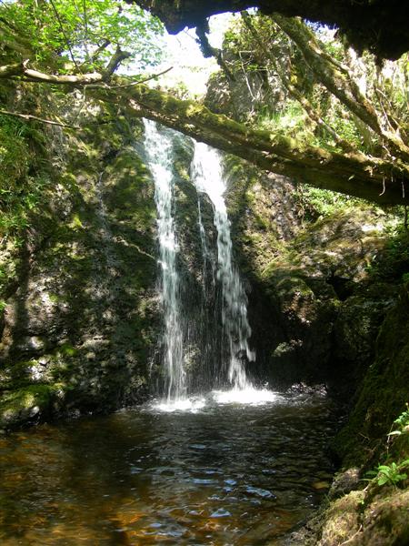
Waterfall on Sheil Burn A small waterfall on this attractive moorland burn.
Waterfall on Sheil Burn
A small waterfall on this attractive moorland burn.
Clear fell in Glenalla Forest Extensive felling has taken place recently in Glenalla Forest. This view looks towards Glenalla Fell.
Clear fell in Glenalla Forest
Extensive felling has taken place recently in Glenalla Forest. This view looks towards Glenalla Fell.
A Glenalla Forest view Looking over open moorland towards Clauchrie Hill on a lovely early May morning.
A Glenalla Forest view
Looking over open moorland towards Clauchrie Hill on a lovely early May morning.
Towards Glenalla Fell Looking towards Glenalla Fell from the new forest road that connects with the old Garleffin Road. This was taken during a Coronavirus exercise outing.
Towards Glenalla Fell
Looking towards Glenalla Fell from the new forest road that connects with the old Garleffin Road. This was taken during a Coronavirus exercise outing.
Red Glen
Red Glen
Hillside
Hillside
Heather And Trees This open area lies parallel to the track.  Viewed in mid-August with the heather in full bloom.
Heather And Trees
This open area lies parallel to the track. Viewed in mid-August with the heather in full bloom.
Into the forest On the track leading towards the Black Hill of Garleffin. By early 2020, the track had been upgraded to allow timber extraction - see <a href="https://www.geograph.org.uk/photo/6465331">NX3599 : Timber stacks on Garleffin Road</a>
Into the forest
On the track leading towards the Black Hill of Garleffin. By early 2020, the track had been upgraded to allow timber extraction - see NX3599 : Timber stacks on Garleffin Road
Heathery Bank A fine display of heather beside the forest track.
Heathery Bank
A fine display of heather beside the forest track.
Old Quarry An old quarry, now overgrown with vegetation that has seeded naturally.  The Explorer map confirms this being on the very edge of the square.
Old Quarry
An old quarry, now overgrown with vegetation that has seeded naturally. The Explorer map confirms this being on the very edge of the square.
Clear fell A clear fell area in Glenalla Forest, with Clauchrie Hill in the background.
Clear fell
A clear fell area in Glenalla Forest, with Clauchrie Hill in the background.
Forest and Moor Trees of various ages and stages in Glenalla Forest.
Forest and Moor
Trees of various ages and stages in Glenalla Forest.
Forest edge The edge of the Galloway Forest Park. To see the difference after clear-felling, look at <a href="https://www.geograph.org.uk/photo/4489420">NS3400 : Clear fell edge at Glenalla</a>, taken 8 years later.
Forest edge
The edge of the Galloway Forest Park. To see the difference after clear-felling, look at NS3400 : Clear fell edge at Glenalla, taken 8 years later.
Show me another place!

Back Fell is located at Grid Ref: NS3501 (Lat: 55.277023, Lng: -4.5883763)

Unitary Authority: South Ayrshire

Police Authority: Ayrshire

What 3 Words

///gladiator.lemons.daunting. Near Maybole, South Ayrshire

Nearby Locations

Back Fell

Related Wikis

Ayr, Carrick and Cumnock (UK Parliament constituency)

Ayr, Carrick and Cumnock is a county constituency represented in the House of Commons of the Parliament of the United Kingdom. It was created for the 2005...

Blairquhan Castle

Blairquhan ( blair-WHAHN, Scots: Blairwhan) is a Regency era castle near Maybole in South Ayrshire, Scotland. It was the historic home of the Hunter-Blair...

Straiton

Straiton is a village on the River Girvan in South Ayrshire in Scotland. It lies in the hills between Kirkmichael, Dalmellington, Crosshill, and Maybole...

Drunmore Linn

Drunmore Linn is a waterfall of Scotland, near Straiton, South Ayrshire. == See also == Waterfalls of Scotland == References ==

Nearby Amenities

Located within 500m of 55.277023,-4.5883763
Mid Fell
Natural: peak
Lat/Long: 55.2748249/-4.5943871
Back Fell
Ele: 425
Natural: peak
Lat/Long: 55.2768912/-4.5928657
Fore Fell
Ele: 428
Natural: peak
Lat/Long: 55.2749484/-4.5909775
The data included in this document is from www.openstreetmap.org. The data is made available under ODbL.

Have you been to Back Fell?

Leave your review of Back Fell below (or comments, questions and feedback).