Shantron Hill

Hill, Mountain in Dunbartonshire

Scotland

Shantron Hill

Gates to Rossdhu House
Gates to Rossdhu House Credit: Eirian Evans

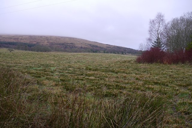
Shantron Hill is a prominent landmark located in Dunbartonshire, Scotland. Standing at an elevation of 365 meters (1,198 feet), it is classified as a hill rather than a mountain. Despite its relatively moderate height, Shantron Hill offers breathtaking panoramic views of the surrounding landscape.

Situated in a rural area, Shantron Hill is characterized by its rugged terrain and abundant vegetation. The hill is predominantly covered in heather, providing a unique purple hue to the landscape during the blooming season. The vegetation also includes grasses, wildflowers, and scattered trees, adding to the scenic beauty of the area.

Hiking enthusiasts can explore various trails that lead to the summit of Shantron Hill. These trails offer a moderate level of difficulty, with some sections requiring a bit of scrambling over rocky outcrops. As climbers ascend, they are rewarded with stunning vistas of the nearby Loch Lomond and the Trossachs National Park.

The hill is home to a diverse array of wildlife, including red deer, rabbits, and a variety of bird species. Birdwatchers often visit Shantron Hill to catch a glimpse of birds such as red kites, buzzards, and peregrine falcons.

Given its accessibility and natural beauty, Shantron Hill attracts both locals and tourists alike. It is a popular destination for outdoor activities such as picnicking, photography, and nature walks. Whether one seeks solitude in nature or an adventurous hike, Shantron Hill offers a tranquil and picturesque experience for all.

If you have any feedback on the listing, please let us know in the comments section below.

Shantron Hill Images

Images are sourced within 2km of 56.052368/-4.671596 or Grid Reference NS3387. Thanks to Geograph Open Source API. All images are credited.

Gates to Rossdhu House
Junction of A82 and A817 The junction as viewed from the A817. The Loch Lomond Golf Club occupies the ground beyond the roads.
Junction of A82 and A817
The junction as viewed from the A817. The Loch Lomond Golf Club occupies the ground beyond the roads.
Lay-by on the A82 near Loch Lomond
A82 near Loch Lomond
A hazardous hole on the Carrick Golf Course Carrick Golf Course 14th Hole.  This a Par 3 hole; indicating that with one stroke the golfer ought to land his/her ball on the green and the ball should not then roll across and off the green. This requires a lofted club so that the ball lands as near vertically as possible.
The distance from tee to green is 199 yards but it has an elevated tee which is approximately 90 feet higher than the green.
It is rated with a stroke index of 17 which means that it is the second hardest hole of the course on which to achieve ‘Par’.
The view from the tee is magnificent even on a winter’s day. An unlucky golfer, who loses their ball in the intervening bracken and undergrowth, might use the excuse that they were distracted by the wonderful views of Loch Lomond and the slopes of Ben Lomond.
A public footpath and cycle track runs low down, half way between the tee and the green. The golfers cannot see the footpath. The walkers and cyclists can see the green but cannot see the tee. They are, however, able to hear the crack of the club on the ball. 
The Course opened in 2007. I have not yet heard of any fatalities.
A hazardous hole on the Carrick Golf Course
Carrick Golf Course 14th Hole. This a Par 3 hole; indicating that with one stroke the golfer ought to land his/her ball on the green and the ball should not then roll across and off the green. This requires a lofted club so that the ball lands as near vertically as possible. The distance from tee to green is 199 yards but it has an elevated tee which is approximately 90 feet higher than the green. It is rated with a stroke index of 17 which means that it is the second hardest hole of the course on which to achieve ‘Par’. The view from the tee is magnificent even on a winter’s day. An unlucky golfer, who loses their ball in the intervening bracken and undergrowth, might use the excuse that they were distracted by the wonderful views of Loch Lomond and the slopes of Ben Lomond. A public footpath and cycle track runs low down, half way between the tee and the green. The golfers cannot see the footpath. The walkers and cyclists can see the green but cannot see the tee. They are, however, able to hear the crack of the club on the ball. The Course opened in 2007. I have not yet heard of any fatalities.
Shalom, Muirlands, near Arden Shalom is the name of the private house which was formerly Muirlands Primary School. It was the school for the surrounding rural area. The hamlet of Muirlands, even today, consists only of eight dwellings. There are no markings to indicate that you are entering or leaving Muirlands other than a couple of "Reduce Speed Now" signs. 

The school was built in 1869 by the Laird of Luss to provide education for the local community and was also used as a church and Sunday school. 

The Old School House, built in 1880, is not a listed building and is approximately 50 metres north of Shalom. It was presumably the teacher's accommodation.  

The Gothic style "Shalom" is Category B listed. Among its external features are the gabled porch and the small candle snuffer spire with fish-scale slating, which originally housed the church bell. A new village school in Luss was built in 1970.
Shalom, Muirlands, near Arden
Shalom is the name of the private house which was formerly Muirlands Primary School. It was the school for the surrounding rural area. The hamlet of Muirlands, even today, consists only of eight dwellings. There are no markings to indicate that you are entering or leaving Muirlands other than a couple of "Reduce Speed Now" signs. The school was built in 1869 by the Laird of Luss to provide education for the local community and was also used as a church and Sunday school. The Old School House, built in 1880, is not a listed building and is approximately 50 metres north of Shalom. It was presumably the teacher's accommodation. The Gothic style "Shalom" is Category B listed. Among its external features are the gabled porch and the small candle snuffer spire with fish-scale slating, which originally housed the church bell. A new village school in Luss was built in 1970.
A82, A817 junction The A82 is a trunk road in Scotland. It is the principal route from Lowland Scotland to the western Scottish Highlands, running from Glasgow to Inverness, going by Loch Lomond, Glen Coe, Fort William and the Great Glen. It is 167 miles long.
<span class="nowrap"><a title="https://www.sabre-roads.org.uk/wiki/index.php?title=A82" rel="nofollow ugc noopener" href="https://www.sabre-roads.org.uk/wiki/index.php?title=A82">Link</a><img style="margin-left:2px;" alt="External link" title="External link - shift click to open in new window" src="https://s1.geograph.org.uk/img/external.png" width="10" height="10"/></span>
A82, A817 junction
The A82 is a trunk road in Scotland. It is the principal route from Lowland Scotland to the western Scottish Highlands, running from Glasgow to Inverness, going by Loch Lomond, Glen Coe, Fort William and the Great Glen. It is 167 miles long. LinkExternal link
A82, northbound The A82 is a trunk road in Scotland. It is the principal route from Lowland Scotland to the western Scottish Highlands, running from Glasgow to Inverness, going by Loch Lomond, Glen Coe, Fort William and the Great Glen. It is 167 miles long.
<span class="nowrap"><a title="https://www.sabre-roads.org.uk/wiki/index.php?title=A82" rel="nofollow ugc noopener" href="https://www.sabre-roads.org.uk/wiki/index.php?title=A82">Link</a><img style="margin-left:2px;" alt="External link" title="External link - shift click to open in new window" src="https://s1.geograph.org.uk/img/external.png" width="10" height="10"/></span>
A82, northbound
The A82 is a trunk road in Scotland. It is the principal route from Lowland Scotland to the western Scottish Highlands, running from Glasgow to Inverness, going by Loch Lomond, Glen Coe, Fort William and the Great Glen. It is 167 miles long. LinkExternal link
Old milestone This red sandstone milestone, 5 miles from Helensburgh on the B832 is about 120m southwest of Duchlage Farm and between Telegraph Poles 5 and 6 on the northwest side of the road.   It is marked on the 1899 OS map but not on the 1864 version.
Old milestone
This red sandstone milestone, 5 miles from Helensburgh on the B832 is about 120m southwest of Duchlage Farm and between Telegraph Poles 5 and 6 on the northwest side of the road. It is marked on the 1899 OS map but not on the 1864 version.
Old milestone Looking north east, the junction with the A82 on the west side of Loch Lomond is just round the corner.  This is the only milestone marked on the OS Landranger on the 5 mile route from Helensburgh.
Old milestone
Looking north east, the junction with the A82 on the west side of Loch Lomond is just round the corner. This is the only milestone marked on the OS Landranger on the 5 mile route from Helensburgh.
Trees near to Duchlage The trees are on the west side of the A82 beside Loch Lomond but are seen from the B832 near to the junction of the two roads.
Trees near to Duchlage
The trees are on the west side of the A82 beside Loch Lomond but are seen from the B832 near to the junction of the two roads.
Field east of Blairnile The field lies between Blairnile and Blairglas Cottage on the north side of the B832; its appearance shows it to be rough grazing and in the distance, higher on the slope the ground is moorland.
Field east of Blairnile
The field lies between Blairnile and Blairglas Cottage on the north side of the B832; its appearance shows it to be rough grazing and in the distance, higher on the slope the ground is moorland.
A rashy field, Blairnile The reeds growing in this obviously wet field had recently been mown.
A rashy field, Blairnile
The reeds growing in this obviously wet field had recently been mown.
B832 A bridge over the Oran Burn west of Loch Lomond.
B832
A bridge over the Oran Burn west of Loch Lomond.
B832 and A82 road junction
Allt a' Ghuallian Wood An oak wood beside Loch Lomond.
Allt a' Ghuallian Wood
An oak wood beside Loch Lomond.
South on the B832 beyond Duchlage
Formal gateway, Ross Park
Show me another place!

Shantron Hill is located at Grid Ref: NS3387 (Lat: 56.052368, Lng: -4.671596)

Unitary Authority: Argyll and Bute

Police Authority: Argyll and West Dunbartonshire

What 3 Words

///refills.tailed.friction. Near Helensburgh, Argyll & Bute

Related Wikis

2000 Solheim Cup

The 6th Solheim Cup Match was held between 6 and 8 October 2000 at Loch Lomond Golf Club, Luss, Dunbartonshire, Scotland. Europe won the trophy for the...

Loch Lomond Golf Club

Loch Lomond Golf Club is located in Luss, Argyll & Bute, Scotland on the shore of Loch Lomond. The course occupies land previously held by Clan Colquhoun...

River Leven, Dunbartonshire

The River Leven (Scottish Gaelic: Uisge Leamhna) is a stretch of water in West Dunbartonshire, Scotland, flowing from Loch Lomond in the North to the River...

Inchgalbraith

Inchgalbraith is an islet in Loch Lomond, Scotland, and is the ancestral home of Clan Galbraith. == History == Inchgalbraith, is as its name implies, connected...

Have you been to Shantron Hill?

Leave your review of Shantron Hill below (or comments, questions and feedback).