Glengap Hill

Hill, Mountain in Ayrshire

Scotland

Glengap Hill

Slope descending towards Corrn Roy Corrn Roy is an unusual name for a stream; it flows below the hill slope to meet and join the greater watercourse, Balloch Burn.
Haggis Hill is sunlit at the left side of the image; Larg Hill is wooded, at its centre.
Slope descending towards Corrn Roy Credit: Trevor Littlewood

Glengap Hill is a prominent hill located in Ayrshire, Scotland. It stands at an elevation of approximately 238 meters (780 feet) above sea level, making it a significant landmark in the region. The hill is situated in the countryside, near the small village of Dalmellington, and is surrounded by picturesque natural beauty.

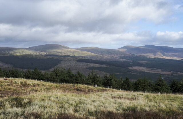
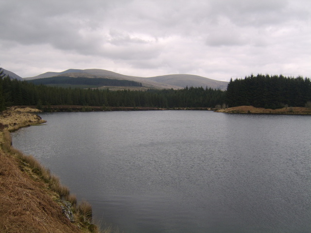
Glengap Hill is characterized by its rolling green slopes and rugged terrain. It is predominantly covered in grass and heather, with scattered patches of woodland dotting its lower slopes. The hill offers stunning panoramic views of the surrounding countryside, including nearby Loch Doon and the Galloway Forest Park.

The hill is a popular destination for outdoor enthusiasts and nature lovers. It provides ample opportunities for hiking, walking, and birdwatching. The diverse flora and fauna of the area make it a haven for wildlife, with sightings of red grouse, curlews, and pheasants being common.

Glengap Hill is also of historical significance, as it is home to several ancient standing stones and burial mounds. These archaeological sites provide insights into the area's rich past and attract visitors interested in exploring the region's prehistoric heritage.

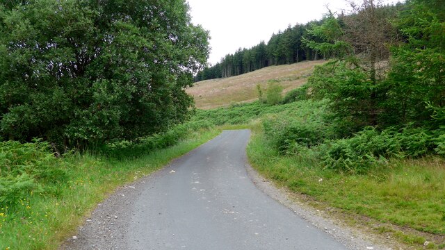
Access to Glengap Hill is relatively easy, with several footpaths and trails leading to its summit. The hill is well-maintained, and its paths are regularly used by locals and tourists alike. Whether it's for a leisurely stroll or a more challenging hike, Glengap Hill offers a rewarding and memorable experience for anyone wishing to explore the natural beauty and history of Ayrshire.

If you have any feedback on the listing, please let us know in the comments section below.
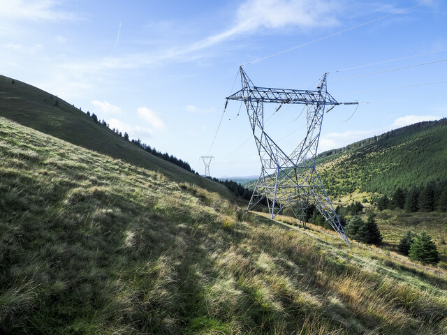
Glengap Hill Images

Images are sourced within 2km of 55.200657/-4.6143155 or Grid Reference NX3392. Thanks to Geograph Open Source API. All images are credited.

Slope descending towards Corrn Roy Corrn Roy is an unusual name for a stream; it flows below the hill slope to meet and join the greater watercourse, Balloch Burn.
Haggis Hill is sunlit at the left side of the image; Larg Hill is wooded, at its centre.
Slope descending towards Corrn Roy
Corrn Roy is an unusual name for a stream; it flows below the hill slope to meet and join the greater watercourse, Balloch Burn. Haggis Hill is sunlit at the left side of the image; Larg Hill is wooded, at its centre.
Forest road crossing the Balloch Burn From the image it's not immediately apparent that there's a stream to be crossed or even that there's a bridge, but the Balloch Burn is there.
Forest road crossing the Balloch Burn
From the image it's not immediately apparent that there's a stream to be crossed or even that there's a bridge, but the Balloch Burn is there.
Warning notices beside forest road The road is passing through coniferous plantations above the Balloch Burn.
Warning notices beside forest road
The road is passing through coniferous plantations above the Balloch Burn.
Meandering of Balloch Burn The Balloch Burn winds its way across the foot of the scene joining another stream, the unusually named Corrn Roy, which drains the valley ahead.
Pinbreck Hill is the main hill in view with the shadowed flank of Glengap Hill rising at the right side of the image.
Meandering of Balloch Burn
The Balloch Burn winds its way across the foot of the scene joining another stream, the unusually named Corrn Roy, which drains the valley ahead. Pinbreck Hill is the main hill in view with the shadowed flank of Glengap Hill rising at the right side of the image.
High voltage power lines on hill slope The electricity transmission lines are on a northern slope above the valley of the Balloch Burn. 
The distant hill is Pinbreck Hill.
High voltage power lines on hill slope
The electricity transmission lines are on a northern slope above the valley of the Balloch Burn. The distant hill is Pinbreck Hill.
Pylon line crossing north side of Haggis Hill The electricity transmission lines pass through the col between Haggis Hill, rising steeply to the left, and the wooded Larg Hill which is to the right.
Pylon line crossing north side of Haggis Hill
The electricity transmission lines pass through the col between Haggis Hill, rising steeply to the left, and the wooded Larg Hill which is to the right.
Summit area of Changue Changue is one of several grassy, steep-sided hills around the valley of the Balloch Burn. The view is from the accepted summit as recorded on the Hillbagging website - NX 3216 9193 - although OS mapping at the 1:25 000 scale records a spot height a little to the north. (Not that that necessarily means that it regards the high point as being there.)
The distant hill is Craigenreoch; the valley of the Balloch Burn lies between that and Changue.
Summit area of Changue
Changue is one of several grassy, steep-sided hills around the valley of the Balloch Burn. The view is from the accepted summit as recorded on the Hillbagging website - NX 3216 9193 - although OS mapping at the 1:25 000 scale records a spot height a little to the north. (Not that that necessarily means that it regards the high point as being there.) The distant hill is Craigenreoch; the valley of the Balloch Burn lies between that and Changue.
Coniferous trees beyond fence on Rowantree Hill A gentle grassy slope with some heather descends from Rowantree Hill towards the fence bounding a coniferous plantation.
The hill range in the distance runs from Tarfessock, in from the left, to The Merrick at the right.
Coniferous trees beyond fence on Rowantree Hill
A gentle grassy slope with some heather descends from Rowantree Hill towards the fence bounding a coniferous plantation. The hill range in the distance runs from Tarfessock, in from the left, to The Merrick at the right.
Grooved slope, part of Rowantree Hill The grooved slope is on the northern side of Rowantree Hill; it's seen from the eastern slope of Glengap Hill across a valley where much of the water of the unusually named stream, Corrn Roy, is gathered.
A narrow minor road can be seen descending across the farthest slope; the stretch in view is known as Nick of the Balloch.
Grooved slope, part of Rowantree Hill
The grooved slope is on the northern side of Rowantree Hill; it's seen from the eastern slope of Glengap Hill across a valley where much of the water of the unusually named stream, Corrn Roy, is gathered. A narrow minor road can be seen descending across the farthest slope; the stretch in view is known as Nick of the Balloch.
Broad ridge extending towards Glengap Hill Being just the northward extension of Rowantree Hill Glengap Hill has no real summit but its height is maintained for some distance ahead before the ridge plunges down steeply. Both the east and west flanks are steep too.
Broad ridge extending towards Glengap Hill
Being just the northward extension of Rowantree Hill Glengap Hill has no real summit but its height is maintained for some distance ahead before the ridge plunges down steeply. Both the east and west flanks are steep too.
Slope rising to summit of Craigenreoch The summit of Craigenreoch is clearly uphill to the left, out of the image.
A shower has just passed over; its associated cloud can be seen in the distance heading towards The Merrick and other hills.
Merrick is at the centre of the image.
Slope rising to summit of Craigenreoch
The summit of Craigenreoch is clearly uphill to the left, out of the image. A shower has just passed over; its associated cloud can be seen in the distance heading towards The Merrick and other hills. Merrick is at the centre of the image.
Heading north to the Nick of the Balloch
Poor surface on the Nick of the Balloch road This lovely narrow moorland road has a surface which has deteriorated badly.
Poor surface on the Nick of the Balloch road
This lovely narrow moorland road has a surface which has deteriorated badly.
The road descending the Nick of the Balloch This lovely narrow moorland road has a surface which has deteriorated badly.  The stream below is the Corrn Roy (no mis-spelling, note!).
The road descending the Nick of the Balloch
This lovely narrow moorland road has a surface which has deteriorated badly. The stream below is the Corrn Roy (no mis-spelling, note!).
Poor surface on the road descending the Nick of the Balloch This is also part of Cycle Route 7 - 547.2 miles long from Sunderland in the northeast of England to Inverness.
Poor surface on the road descending the Nick of the Balloch
This is also part of Cycle Route 7 - 547.2 miles long from Sunderland in the northeast of England to Inverness.
The Nick of the Balloch road This is also part of Cycle Route 7 - 547.2 miles long from Sunderland in the northeast of England to Inverness.
The Nick of the Balloch road
This is also part of Cycle Route 7 - 547.2 miles long from Sunderland in the northeast of England to Inverness.
Balloch Burn near confluence with Corrn Roy
Craigenreoch Easy going from minor road to NE on a lovely spring morning.
Name: Craigenreoch
Hill number: 1718
Height: 565m / 1854ft
Area: 27B: Carrick and Galloway
Class: Ma,5D
Grid ref: NX 33519 91078
Summit feature: trig point
Drop: 178m
Col: 387m  NX346926
Craigenreoch
Easy going from minor road to NE on a lovely spring morning. Name: Craigenreoch Hill number: 1718 Height: 565m / 1854ft Area: 27B: Carrick and Galloway Class: Ma,5D Grid ref: NX 33519 91078 Summit feature: trig point Drop: 178m Col: 387m NX346926
Show me another place!

Glengap Hill is located at Grid Ref: NX3392 (Lat: 55.200657, Lng: -4.6143155)

Unitary Authority: South Ayrshire

Police Authority: Ayrshire

What 3 Words

///comedians.sheds.regaining. Near Girvan, South Ayrshire

Nearby Locations

Glengap Hill

Related Wikis

Stinchar Falls

Stinchar Falls is a waterfall of Scotland. It is located on the Stinchar Burn, east of Barr in Ayrshire. == See also == Waterfalls of Scotland == References ==

Barr, Ayrshire

Barr is a village in the South West of Ayrshire, Scotland, approximately 8 miles (13 km) from the town of Girvan. There are various opinions as to the...

Shalloch on Minnoch

Shalloch on Minnoch is a hill in the Range of the Awful Hand, a sub-range of the Galloway Hills range, part of the Southern Uplands of Scotland. It is...

Kirriereoch Loch

Kirriereoch Loch is a small, shallow, square shaped, freshwater loch in Dumfries and Galloway, in the Southern Uplands of south-west Scotland. It lies...

Have you been to Glengap Hill?

Leave your review of Glengap Hill below (or comments, questions and feedback).