Am Faochagach

Hill, Mountain in Ross-shire

Scotland

Am Faochagach

Towards Am Faochagach
Towards Am Faochagach Credit: Steven Brown

Am Faochagach is a prominent hill/mountain located in Ross-shire, Scotland. It is part of the larger Ben Wyvis range and sits at an elevation of 953 meters (3,127 feet). The name Am Faochagach translates to "the hidden one" in Scottish Gaelic, which is fitting considering its remote and secluded location.

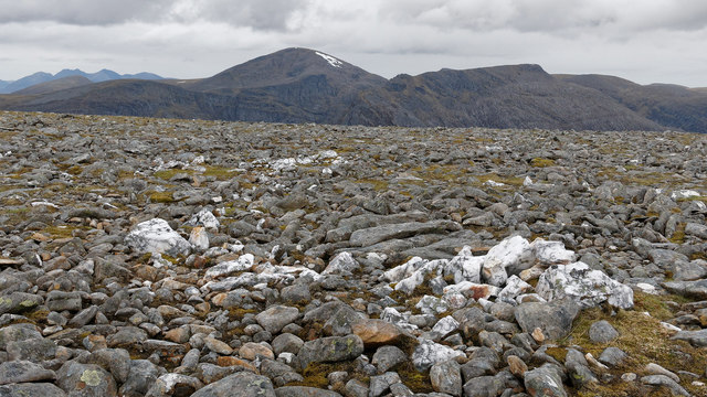
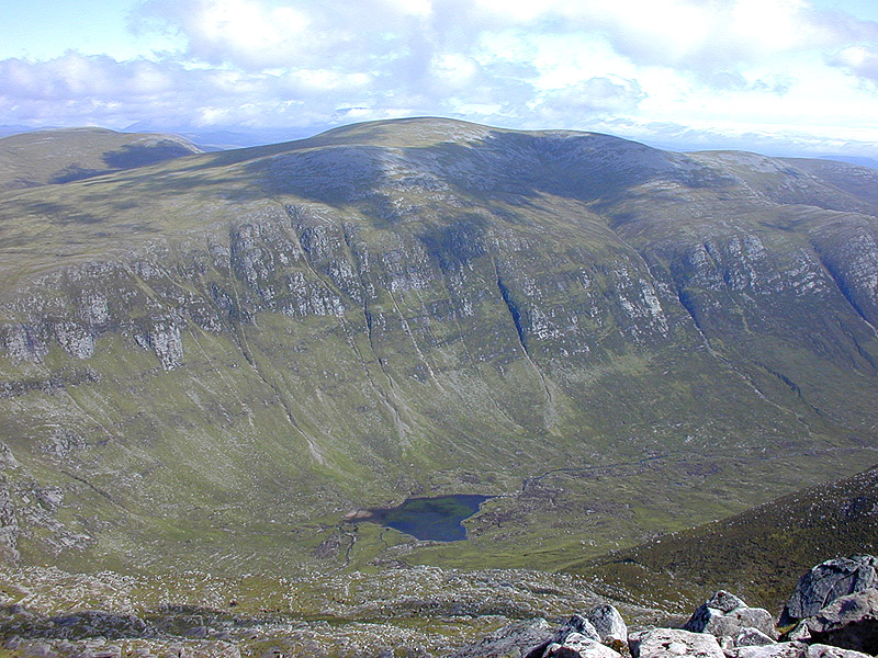
This hill/mountain is characterized by its steep and rugged terrain, making it a challenging climb for experienced hikers and mountaineers. It is composed of a mixture of rocks and grassy slopes, with occasional patches of heather. The summit offers panoramic views of the surrounding countryside, including the nearby Munros of Ben Wyvis and Beinn Dearg.

Am Faochagach is known for its diverse wildlife, with a variety of bird species, including golden eagles, peregrine falcons, and ptarmigans, frequently spotted in the area. Red deer can also be seen roaming the lower slopes, adding to the natural beauty of the landscape.

The hill/mountain is accessible via various routes, with the most common starting point being the small village of Garve. The ascent typically takes around 4-6 hours, depending on fitness levels and weather conditions. While there are no official paths, navigation skills are required to reach the summit safely.

Overall, Am Faochagach offers a challenging and rewarding hiking experience for outdoor enthusiasts, showcasing the magnificent Scottish Highlands scenery and wildlife.

If you have any feedback on the listing, please let us know in the comments section below.

Am Faochagach Images

Images are sourced within 2km of 57.771817/-4.8537306 or Grid Reference NH3079. Thanks to Geograph Open Source API. All images are credited.

Towards Am Faochagach
Cairn atop Am Faochagach
Carn Gorm-Loch Showing the grassy northern slopes of Carn Gorm-Loch
Carn Gorm-Loch
Showing the grassy northern slopes of Carn Gorm-Loch
The bealach between Carn Gorm-Loch and Am Faochagach Shortish grass and not too boggy an area makes this reasonably good walking
The bealach between Carn Gorm-Loch and Am Faochagach
Shortish grass and not too boggy an area makes this reasonably good walking
Just east of the summit of Meallan Ban Mist, low cloud, looking into the glen of the Allt a Chrom-uillt.
Just east of the summit of Meallan Ban
Mist, low cloud, looking into the glen of the Allt a Chrom-uillt.
The flat ridge leading to Am Faochagach Beyond lies the more intriguing mountain mass of Beinn Dhearg.
The flat ridge leading to Am Faochagach
Beyond lies the more intriguing mountain mass of Beinn Dhearg.
North col of Am Faochagach A cloudy day on the north side of Am Faochagach.
North col of Am Faochagach
A cloudy day on the north side of Am Faochagach.
Am Faochagach (summit) Looking towards Beinn Dearg and Cona' Mheall from the summit of Am Faochagach.
Am Faochagach (summit)
Looking towards Beinn Dearg and Cona' Mheall from the summit of Am Faochagach.
On the flank of Meall Gorm Looking over the valley of the Allt Glas Toll Mor towards the beallach where  the normal path from Dirrie Mor first hits the ridge that leads to the Munro summit of Am Faochagach. The Fannichs lie beyond the beallach.
On the flank of Meall Gorm
Looking over the valley of the Allt Glas Toll Mor towards the beallach where the normal path from Dirrie Mor first hits the ridge that leads to the Munro summit of Am Faochagach. The Fannichs lie beyond the beallach.
South-east ridge of Meall Gorm The final part of the ridge is flat as it approaches the summit.  The vegetation changes abruptly from grass to moss to bare stony ground. By contrast the sides of the ridge are well vegetated. Ben Wyvis on the skyline.
South-east ridge of Meall Gorm
The final part of the ridge is flat as it approaches the summit. The vegetation changes abruptly from grass to moss to bare stony ground. By contrast the sides of the ridge are well vegetated. Ben Wyvis on the skyline.
Snow beds below Am Faochagach Melting would have been slow in the cold and cloudy conditions experienced here, although later rain would have helped put heat into the snowpack.
Snow beds below Am Faochagach
Melting would have been slow in the cold and cloudy conditions experienced here, although later rain would have helped put heat into the snowpack.
Coire Gorm beside Am Faochagach Meal Gorm is the rounded summit emerging from the rather flat plateau.
Coire Gorm beside Am Faochagach
Meal Gorm is the rounded summit emerging from the rather flat plateau.
Sheltering from the wind,  summit cairn, Am Faochagach A windy place and little cover to escape from it.  A contrast to the conditions at the base of the mountain.
Sheltering from the wind, summit cairn, Am Faochagach
A windy place and little cover to escape from it. A contrast to the conditions at the base of the mountain.
Subsidiary cairn, Am Faochagach A smaller cairn on the summit plateau provides the foreground to a view of the principal mountains of the Fisherfield Forest.  The loch visible is Loch a Bhraoin separating the Fannich group from the mountains of the Fisherfield Forest.
Subsidiary cairn, Am Faochagach
A smaller cairn on the summit plateau provides the foreground to a view of the principal mountains of the Fisherfield Forest. The loch visible is Loch a Bhraoin separating the Fannich group from the mountains of the Fisherfield Forest.
Quartz on the ridge to Am Faochagach One outcrop on an otherwise grey barren ridge leading to Am Faochagach.
Quartz on the ridge to Am Faochagach
One outcrop on an otherwise grey barren ridge leading to Am Faochagach.
On the ridge heading for Am Faochagach With a gentle gradient and a lack of vegetation, the stony ridge is easy to walk over.
On the ridge heading for Am Faochagach
With a gentle gradient and a lack of vegetation, the stony ridge is easy to walk over.
Cairn on the Am Faochagach ridge From here the footpath leaves the tracked ridge to descend to the Dirrie Mor. In the background is Beinn Dhearg.
Cairn on the Am Faochagach ridge
From here the footpath leaves the tracked ridge to descend to the Dirrie Mor. In the background is Beinn Dhearg.
Allt Glas Toll Mor Looking downstream in the upper region of the river.
Allt Glas Toll Mor
Looking downstream in the upper region of the river.
Show me another place!

Am Faochagach is located at Grid Ref: NH3079 (Lat: 57.771817, Lng: -4.8537306)

Unitary Authority: Highland

Police Authority: Highlands and Islands

What 3 Words

///delay.bucks.basics. Near Ullapool, Highland

Nearby Locations

Am Faochagach

Related Wikis

Am Faochagach

Am Faochagach (953 m) is a mountain in the Northwest Highlands of Scotland. It is located in Wester Ross, north of the main road to Ullapool. A rounded...

Cona' Mheall

Cona' Mheall (978 m) is a mountain in the Northwest Highlands of Scotland. It is located near Ullapool in Wester Ross. Taking the form of a fine rocky...

Beinn Dearg (Ullapool)

Beinn Dearg (one of a number of Scottish hills of that name) is a mountain in the Inverlael area of the Highlands of Scotland. It is most frequently climbed...

Loch Glascarnoch

Loch Glascarnoch is a 7-kilometre-long (4.3 mi) reservoir in the highlands of Scotland between Ullapool and Inverness. It is dammed on its eastern end...

Nearby Amenities

Located within 500m of 57.771817,-4.8537306
Am Faochagach
Description: The place of the shells
Ele: 953
Marilyn: yes
Munro: yes
Munro Number: M210
Natural: peak
Prominence: 367
Source: NPE
Wikidata: Q13125481
Lat/Long: 57.7717981/-4.8538839
The data included in this document is from www.openstreetmap.org. The data is made available under ODbL.

Have you been to Am Faochagach?

Leave your review of Am Faochagach below (or comments, questions and feedback).