Corlick Hill

Hill, Mountain in Renfrewshire

Scotland

Corlick Hill

Outcrop, potential site of TP15796 Loudenward No evidence of OS surface block, top soil not deep enough for it to be buried.
Outcrop, potential site of TP15796 Loudenward Credit: cowboycoder

Corlick Hill is a prominent hill located in Renfrewshire, Scotland. Situated approximately 20 miles southwest of Glasgow, it is part of the Clyde Muirshiel Regional Park and offers stunning views of the surrounding countryside.

Standing at a height of 468 meters (1,535 feet), Corlick Hill is not technically classified as a mountain, but rather a hill. However, its impressive elevation and commanding position make it a popular destination for hikers and nature enthusiasts.

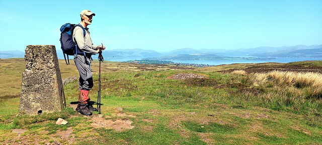
The hill is characterized by its steep slopes, which are covered in heather and grasses, creating a picturesque landscape. The summit of Corlick Hill is relatively flat, providing ample space for visitors to pause and take in the panoramic vistas that stretch as far as the Isle of Arran and the Ayrshire coast.

Access to Corlick Hill is relatively straightforward, with a well-marked path leading to the summit from the nearby village of Lochwinnoch. The climb is moderately challenging, but the rewards are well worth the effort.

Aside from its natural beauty, Corlick Hill is also of historical significance. The hill is home to the remains of an Iron Age fort, known as Knockoura, which dates back over 2,000 years. The fort's defensive walls and ditches can still be seen today, providing a glimpse into the area's ancient past.

Overall, Corlick Hill offers a fantastic opportunity to explore the Scottish countryside, appreciate breathtaking views, and delve into the region's rich history. Whether you're an avid hiker or simply seeking a peaceful retreat, Corlick Hill is a must-visit destination in Renfrewshire.

If you have any feedback on the listing, please let us know in the comments section below.

Corlick Hill Images

Images are sourced within 2km of 55.918286/-4.7371575 or Grid Reference NS2972. Thanks to Geograph Open Source API. All images are credited.
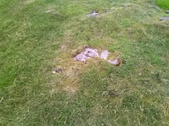
Outcrop, potential site of TP15796 Loudenward No evidence of OS surface block, top soil not deep enough for it to be buried.
Outcrop, potential site of TP15796 Loudenward
No evidence of OS surface block, top soil not deep enough for it to be buried.
Corlick Hill (trig point) Looking towards Kilcreggan and Helensburgh from the summit of Corlick Hill
Corlick Hill (trig point)
Looking towards Kilcreggan and Helensburgh from the summit of Corlick Hill
Gryfe Reservoir No.1
Electricity Sub Station at the top of Auchenfoyle Road
Electricity Sub Station
at the top of Auchenfoyle Road
Knocknairshill Reservoir
Devol Moor
Devol Moor
Knocknairshill, Lillybank, Port Glasgow Looking over Knocknairshill to the Clyde and Cardross.
Knocknairshill, Lillybank, Port Glasgow
Looking over Knocknairshill to the Clyde and Cardross.
Knocknair'shill Reservoir, Greenock
Electricity Board Sub Station
Greenock boundary On the B788 Auchmountain Road above Gibbshill.
Greenock boundary
On the B788 Auchmountain Road above Gibbshill.
Remains of enclosures See <a href="https://www.geograph.org.uk/photo/1853572">NS2973 : Lurg Moor Roman fortlet</a> for a discussion of various other antiquities located nearby on the moor, with links to photographs. Compared to some of those sites, the remains shown in the present photograph are less conspicuous, but they are shown on the 1:25000 OS map.

Several enclosures have been reported in the immediate vicinity of this one, but the remains shown in this photograph are the easiest to pick out visually. See <span class="nowrap"><a title="https://canmore.org.uk/site/41340/burnhead-moor" rel="nofollow ugc noopener" href="https://canmore.org.uk/site/41340/burnhead-moor">Link</a><img style="margin-left:2px;" alt="External link" title="External link - shift click to open in new window" src="https://s1.geograph.org.uk/img/external.png" width="10" height="10"/></span> (at Canmore) for further details; the subject of this photograph is structure "A" in that report, the D-shaped enclosure. Structures "A" and "B" together make up the enclosures that are depicted on the 1:25000 map.

[See <span class="nowrap"><a title="https://www.google.com/maps/d/viewer?mid=1Np6emNB53CxbNJmyJ_LicpxJvus&ll=55.915499%2C-4.72162400000002&z=19" rel="nofollow ugc noopener" href="https://www.google.com/maps/d/viewer?mid=1Np6emNB53CxbNJmyJ_LicpxJvus&ll=55.915499%2C-4.72162400000002&z=19">Link</a><img style="margin-left:2px;" alt="External link" title="External link - shift click to open in new window" src="https://s1.geograph.org.uk/img/external.png" width="10" height="10"/></span> for an annotated satellite image (zoom out for other antiquities located nearby). The satellite view shows some other interesting details nearby: for example, only 60 metres ESE is another feature, the form of two overlapping circles: I examined that area on a later visit: <a href="https://www.geograph.org.uk/photo/2089851">NS3072 : Possible hut circles on Burnhead Moor</a>.]

The present photograph shows two ridges, both greener than the surrounding moor, but with some dark tussocks along their course. The nearer one is straight, and the more distant one is curved into a C-shape, with the open side toward the photographer, so that they are arranged (very roughly) as "C|".

In the foreground, just below the centre of the photograph, part of the nearer (straight) ridge runs across the width of the image, sloping upwards to the right. Behind it is the other (curved) ridge. Only one half of its C-shape is seen in this view; the near end of that arm of the ridge is to the left of and slightly above the centre of the photograph. From there, the ridge can be followed to the right-hand edge of the picture.

Providing confirmation of the view direction, Corlic Hill (called Corlick Hill on the OS map) appears centrally on the skyline.
Remains of enclosures
See NS2973 : Lurg Moor Roman fortlet for a discussion of various other antiquities located nearby on the moor, with links to photographs. Compared to some of those sites, the remains shown in the present photograph are less conspicuous, but they are shown on the 1:25000 OS map. Several enclosures have been reported in the immediate vicinity of this one, but the remains shown in this photograph are the easiest to pick out visually. See LinkExternal link (at Canmore) for further details; the subject of this photograph is structure "A" in that report, the D-shaped enclosure. Structures "A" and "B" together make up the enclosures that are depicted on the 1:25000 map. [See LinkExternal link for an annotated satellite image (zoom out for other antiquities located nearby). The satellite view shows some other interesting details nearby: for example, only 60 metres ESE is another feature, the form of two overlapping circles: I examined that area on a later visit: NS3072 : Possible hut circles on Burnhead Moor.] The present photograph shows two ridges, both greener than the surrounding moor, but with some dark tussocks along their course. The nearer one is straight, and the more distant one is curved into a C-shape, with the open side toward the photographer, so that they are arranged (very roughly) as "C|". In the foreground, just below the centre of the photograph, part of the nearer (straight) ridge runs across the width of the image, sloping upwards to the right. Behind it is the other (curved) ridge. Only one half of its C-shape is seen in this view; the near end of that arm of the ridge is to the left of and slightly above the centre of the photograph. From there, the ridge can be followed to the right-hand edge of the picture. Providing confirmation of the view direction, Corlic Hill (called Corlick Hill on the OS map) appears centrally on the skyline.
Knocknairs Moor The mound in the middle distance is a high point of the moor. A trig point can be seen there; for a closer look, see <a href="https://www.geograph.org.uk/photo/2023086">NS3073 : Trig point on Knocknairs Moor</a>.

The River Clyde is visible in the background. On the far side of the river, and extending from the left-hand edge of the image to behind the trig point, the slopes above the shore-side town of Helenburgh resemble a single low wide hill; behind its highest point, Glen Luss forms a gap in the mountains; the distant Cobbler (<a href="https://www.geograph.org.uk/gridref/NN2505">NN2505</a>) and Ben Ime (<a href="https://www.geograph.org.uk/gridref/NN2508">NN2508</a>) stand in the gap.
Knocknairs Moor
The mound in the middle distance is a high point of the moor. A trig point can be seen there; for a closer look, see NS3073 : Trig point on Knocknairs Moor. The River Clyde is visible in the background. On the far side of the river, and extending from the left-hand edge of the image to behind the trig point, the slopes above the shore-side town of Helenburgh resemble a single low wide hill; behind its highest point, Glen Luss forms a gap in the mountains; the distant Cobbler (NN2505) and Ben Ime (NN2508) stand in the gap.
Trig point on Knocknairs Moor For a view of the trig point in context, see <a href="https://www.geograph.org.uk/photo/2023063">NS3073 : Knocknairs Moor</a>. Its flush bracket number is S4982.

The large town of Greenock is visible on the near shore of the Clyde. Out in the firth, the Rosneath Peninsula can be seen directly behind the trig point, with Loch Long to its left, and the Gare Loch to the right.
Trig point on Knocknairs Moor
For a view of the trig point in context, see NS3073 : Knocknairs Moor. Its flush bracket number is S4982. The large town of Greenock is visible on the near shore of the Clyde. Out in the firth, the Rosneath Peninsula can be seen directly behind the trig point, with Loch Long to its left, and the Gare Loch to the right.
Corner of fence and dry-stone wall The ground to the west is rougher underfoot, not only here, but along the full length of the fence and wall.

For background details on the left, see <a href="https://www.geograph.org.uk/photo/2023063">NS3073 : Knocknairs Moor</a>.

On the right, Ardmore Point (<a href="https://www.geograph.org.uk/gridref/NS3178">NS3178</a>) can be seen jutting out from the far shore of the Clyde. Two hills, close together, can be seen behind it: Ben Bowie (<a href="https://www.geograph.org.uk/gridref/NS3382">NS3382</a>), with the partially-afforested Killoeter (<a href="https://www.geograph.org.uk/gridref/NS3481">NS3481</a>) to its right.
Corner of fence and dry-stone wall
The ground to the west is rougher underfoot, not only here, but along the full length of the fence and wall. For background details on the left, see NS3073 : Knocknairs Moor. On the right, Ardmore Point (NS3178) can be seen jutting out from the far shore of the Clyde. Two hills, close together, can be seen behind it: Ben Bowie (NS3382), with the partially-afforested Killoeter (NS3481) to its right.
Auchmountain Road For the origins of the road's name, see <a href="https://www.geograph.org.uk/photo/2089251">NS2974 : Auchmountain Road</a>.

Knocknairshill Reservoir can be seen on the right: <a href="https://www.geograph.org.uk/photo/71192">NS3073 : Knocknairshill Reservoir</a> / <a href="https://www.geograph.org.uk/photo/1411397">NS3073 : Knocknair'shill Reservoir, Greenock</a> / <a href="https://www.geograph.org.uk/photo/2089238">NS3073 : Knocknairshill Reservoir</a>.

Visible directly beyond the far end of the road are the slopes of Creachan Hill (<a href="https://www.geograph.org.uk/gridref/NS3389">NS3389</a>), with the taller Ben Lomond (<a href="https://www.geograph.org.uk/gridref/NN3602">NN3602</a>) behind.
Auchmountain Road
For the origins of the road's name, see NS2974 : Auchmountain Road. Knocknairshill Reservoir can be seen on the right: NS3073 : Knocknairshill Reservoir / NS3073 : Knocknair'shill Reservoir, Greenock / NS3073 : Knocknairshill Reservoir. Visible directly beyond the far end of the road are the slopes of Creachan Hill (NS3389), with the taller Ben Lomond (NN3602) behind.
Dougliehill Road The photograph was taken from the point where this road leaves <a href="https://www.geograph.org.uk/photo/2089231">NS3073 : Auchmountain Road</a>.

Not far ahead, a short track branches off southwards from Dougliehill Road, leading towards <a href="https://www.geograph.org.uk/photo/2089238">NS3073 : Knocknairshill Reservoir</a>, but the road itself continues on a more or less eastward course (see <a href="https://www.geograph.org.uk/photo/71202">NS3173 : Dougliehill Road</a> and <a href="https://www.geograph.org.uk/photo/840854">NS3273 : Dougliehill Road</a>) across the moor, towards the houses and industrial estates above Port Glasgow.

In relation to the present picture, the Devol Burn flows under Dougliehill Road just beyond the cattle grid, and on the near side of the area of gorse that can be seen to the left (north-east) of the road. See <a href="https://www.geograph.org.uk/photo/5193588">NS3073 : The Devol Burn at Dougliehill Road</a> for a view of the burn, and <a href="https://www.geograph.org.uk/photo/5193581">NS3073 : Cattle grid on Dougliehill Road</a>, taken nearby. Both views are in the opposite direction to the present picture. The 1:25000 map shows the burn and the cattle grid.
Dougliehill Road
The photograph was taken from the point where this road leaves NS3073 : Auchmountain Road. Not far ahead, a short track branches off southwards from Dougliehill Road, leading towards NS3073 : Knocknairshill Reservoir, but the road itself continues on a more or less eastward course (see NS3173 : Dougliehill Road and NS3273 : Dougliehill Road) across the moor, towards the houses and industrial estates above Port Glasgow. In relation to the present picture, the Devol Burn flows under Dougliehill Road just beyond the cattle grid, and on the near side of the area of gorse that can be seen to the left (north-east) of the road. See NS3073 : The Devol Burn at Dougliehill Road for a view of the burn, and NS3073 : Cattle grid on Dougliehill Road, taken nearby. Both views are in the opposite direction to the present picture. The 1:25000 map shows the burn and the cattle grid.
Sluice gate on the Devol Burn This photograph shows one of a pair of sluice gates located on the course of the Devol Burn. Just beyond the left-hand side of the sluice, another part of the burn can be seen joining this one from the right. The other sluice gate is located further up that part of the burn; compare <a href="https://www.geograph.org.uk/photo/2089519">NS3073 : Sluice gate on the Devol Burn</a>.

The foreground section of the burn had itself been diverted here by a wall that is located just 60m to the NNW, and which is shown in <a href="https://www.geograph.org.uk/photo/2089523">NS3073 : Old water valve beside the Devol Burn</a>.

See <a href="https://www.geograph.org.uk/photo/2089231">NS3073 : Auchmountain Road</a> for a view along the section of road that can be seen in the background.

[The first-edition OS map (c.1860) refers to the burn by its present name, Devol Burn, but earlier maps show some variation in the name. For example, John Ainslie's 1796 map shows the lower part of its course, the present-day <a href="https://www.geograph.org.uk/photo/1661703">NS3074 : Devol Glen</a>, as "Divels Glen", while Roy's Military Survey of Scotland (1740s-50s) shows "Devils Glen".]
Sluice gate on the Devol Burn
This photograph shows one of a pair of sluice gates located on the course of the Devol Burn. Just beyond the left-hand side of the sluice, another part of the burn can be seen joining this one from the right. The other sluice gate is located further up that part of the burn; compare NS3073 : Sluice gate on the Devol Burn. The foreground section of the burn had itself been diverted here by a wall that is located just 60m to the NNW, and which is shown in NS3073 : Old water valve beside the Devol Burn. See NS3073 : Auchmountain Road for a view along the section of road that can be seen in the background. [The first-edition OS map (c.1860) refers to the burn by its present name, Devol Burn, but earlier maps show some variation in the name. For example, John Ainslie's 1796 map shows the lower part of its course, the present-day NS3074 : Devol Glen, as "Divels Glen", while Roy's Military Survey of Scotland (1740s-50s) shows "Devils Glen".]
Show me another place!

Corlick Hill is located at Grid Ref: NS2972 (Lat: 55.918286, Lng: -4.7371575)

Unitary Authority: Inverclyde

Police Authority: Renfrewshire and Inverclyde

What 3 Words

///expand.yoga.drift. Near Port Glasgow, Inverclyde

Nearby Locations

Corlick Hill

Related Wikis

Gryffe Reservoirs

The Gryffe Reservoirs, also spelled 'Gryfe', take their name from the River Gryffe, name deriving from the Gaelic garbh meaning "rough stream". are two...

Inverclyde (UK Parliament constituency)

Inverclyde is a parliamentary constituency of the House of Commons of the Parliament of the United Kingdom. It replaced Greenock and Inverclyde and the...

Easter Greenock Castle

Easter Greenock Castle was a castle of unknown design near the burgh of Greenock, Scotland. == History == === Construction and location === Built sometime...

Inverclyde

Inverclyde (Scots: Inerclyde, Scottish Gaelic: Inbhir Chluaidh, pronounced [iɲiɾʲˈxl̪ˠuəj], "mouth of the Clyde") is one of 32 council areas used for local...

Nearby Amenities

Located within 500m of 55.918286,-4.7371575
Corlick Hill
Ele: 303
Natural: peak
Lat/Long: 55.9185366/-4.7364963
Barrier: stile
Lat/Long: 55.9187776/-4.7434466
Generator Manufacturer: Enercon
Generator Method: wind_turbine
Generator Output Electricity: 3 MW
Generator Source: wind
Generator Type: horizontal_axis
Power: generator
Lat/Long: 55.9195512/-4.7348497
Generator Manufacturer: Enercon
Generator Method: wind_turbine
Generator Output Electricity: 3 MW
Generator Source: wind
Generator Type: horizontal_axis
Power: generator
Lat/Long: 55.9167215/-4.7333428
Corlick Hill
Image: https://trigpointinguk-photos.s3.amazonaws.com/345/P345013.jpg
Man Made: survey_point
Operator: Ordnance Survey
Operator Wikidata: Q548721
Ref: S4985
Survey Point Structure: pillar
Website: https://trigpointing.uk/trig/2414
Lat/Long: 55.9182845/-4.7371508
The data included in this document is from www.openstreetmap.org. The data is made available under ODbL.

Have you been to Corlick Hill?

Leave your review of Corlick Hill below (or comments, questions and feedback).