Beinn Chuirn

Hill, Mountain in Perthshire

Scotland

Beinn Chuirn

A85 through Glen Lochy
A85 through Glen Lochy Credit: Steven Brown

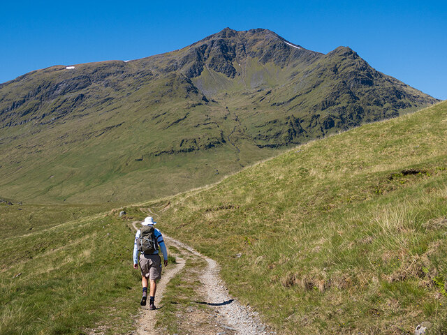
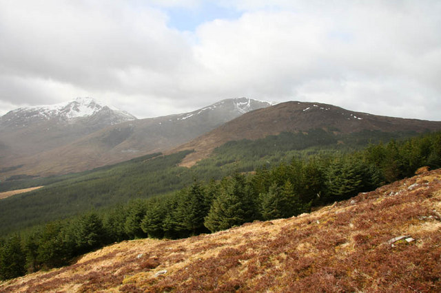
Beinn Chuirn is a prominent hill located in Perthshire, Scotland. It stands at a height of 880 meters (2,887 feet) above sea level and is a popular destination for hikers and outdoor enthusiasts. The hill is part of the Ben Lawers range and offers stunning panoramic views of the surrounding countryside, including Loch Tay and the surrounding mountains.

Beinn Chuirn is known for its rugged terrain, with steep slopes and rocky outcrops making it a challenging but rewarding climb. The hill is also home to a variety of wildlife, including red deer, mountain hares, and a wide range of bird species.

There are several routes to the summit of Beinn Chuirn, with the most popular starting from the village of Lawers. The climb typically takes around 3-4 hours to complete, depending on fitness levels and weather conditions. Once at the top, hikers are rewarded with breathtaking views of the surrounding landscape, making it a must-visit destination for anyone exploring the Perthshire region.

If you have any feedback on the listing, please let us know in the comments section below.

Beinn Chuirn Images

Images are sourced within 2km of 56.423837/-4.789884 or Grid Reference NN2829. Thanks to Geograph Open Source API. All images are credited.

A85 through Glen Lochy
A85 in Glen Lochy
A85 in Glen Lochy
A85 in Glen Lochy
A85 in Glen Lochy
Boulder in the Cononish Glen
The Cononish gold mine below Beinn Chuirn View taken on the walk in to Ben Lui.
The Cononish gold mine below Beinn Chuirn
View taken on the walk in to Ben Lui.
Eas Anie seen from the walk in to Ben Lui Ben Lui begins to emerge on the left.
Eas Anie seen from the walk in to Ben Lui
Ben Lui begins to emerge on the left.
Eas Anie waterfall in dry conditions
Not that way, Tim! The signpost marks the path to the Eas Anie waterfall. We're heading up the track to Ben Lui.
Not that way, Tim!
The signpost marks the path to the Eas Anie waterfall. We're heading up the track to Ben Lui.
The track to Ben Lui The north ridge of Ben Oss intruding from the left.
The track to Ben Lui
The north ridge of Ben Oss intruding from the left.
Heading for Ben Lui The Coire Gaothach looking magnificent.
Heading for Ben Lui
The Coire Gaothach looking magnificent.
The upper reaches of Glen Cononish Looking across the Allt an Rund towards Coire Laoigh.
The upper reaches of Glen Cononish
Looking across the Allt an Rund towards Coire Laoigh.
Nearly at the hill The last of the track up Glen Cononish and the climb up into Coire Gaothach awaits.
Nearly at the hill
The last of the track up Glen Cononish and the climb up into Coire Gaothach awaits.
Allt an Rund
Allt an Rund
Track to Ben Lui
Track to Ben Lui
Track above Cononish The forested slopes of Meall Odhar rise above Cononish. There's an old gold mine on the flank of Beinn Chuirn to the left of the track.
Track above Cononish
The forested slopes of Meall Odhar rise above Cononish. There's an old gold mine on the flank of Beinn Chuirn to the left of the track.
Beinn Chuirn Looking up to the ravine of Eas Anie. Walkers have left their bikes here, having cycled up the valley from Dalrigh. They are probably climbing Ben Lui.
Beinn Chuirn
Looking up to the ravine of Eas Anie. Walkers have left their bikes here, having cycled up the valley from Dalrigh. They are probably climbing Ben Lui.
Looking up the boggy southern slopes of Beinn Chuirn. Taken from the corrie above the Eas Anie waterfall.
Looking up the boggy southern slopes of Beinn Chuirn.
Taken from the corrie above the Eas Anie waterfall.
The summit cairn of Beinn Chuirn, taken from the East Ridge. Beinn Chuirn is an 880 metre high Corbett, with a gold-mine on its eastern slopes.
The summit cairn of Beinn Chuirn, taken from the East Ridge.
Beinn Chuirn is an 880 metre high Corbett, with a gold-mine on its eastern slopes.
Show me another place!

Beinn Chuirn is located at Grid Ref: NN2829 (Lat: 56.423837, Lng: -4.789884)

Unitary Authority: Stirling

Police Authority: Forth Valley

What 3 Words

///inclines.afterglow.warbler. Near Tyndrum, Stirling

Related Wikis

Beinn Chùirn

Beinn Chùirn is a hill five kilometres (3.1 miles) west-south-west of Tyndrum, Scotland, standing on the border of Stirlingshire and Perthshire at the...

Meall Odhar

Meall Odhar is a mountain in the Scottish Highlands, situated about 3 km to the west of Tyndrum, close to the northern boundary of the Loch Lomond and...

Ben Lui

Ben Lui (Scottish Gaelic: Beinn Laoigh) is a mountain in the southern Highlands of Scotland. It is a Munro with a height of 1,130 metres (3,710 ft). Ben...

Tyndrum Hills

The Tyndrum Hills are a mountain range located to the south-west of Tyndrum in the Scottish Highlands, within the Strath Fillan and Breadalbane area. They...

Nearby Amenities

Located within 500m of 56.423837,-4.789884
Beinn Chuirn
Corbett: yes
Description: Cairn hill
Ele: 880
Graham: no
Marilyn: yes
Munro: no
Natural: peak
Prominence: 446
Source: local_knowledge
Source Ele: GPS survey
Wikidata: Q3405785
Wikipedia: en:Beinn Chùirn
Lat/Long: 56.4236112/-4.7891521
Coire na Saobhaidhe
Place: locality
Lat/Long: 56.4254968/-4.7824216
The data included in this document is from www.openstreetmap.org. The data is made available under ODbL.

Have you been to Beinn Chuirn?

Leave your review of Beinn Chuirn below (or comments, questions and feedback).