An Cabar

Hill, Mountain in Ross-shire

Scotland

An Cabar

Road by Loch Fannich Most of the road to Fannich Lodge is smooth tarmac, but there is about 2km on rough gravel. This is the end of the gravel section.
Road by Loch Fannich Credit: Craig Wallace

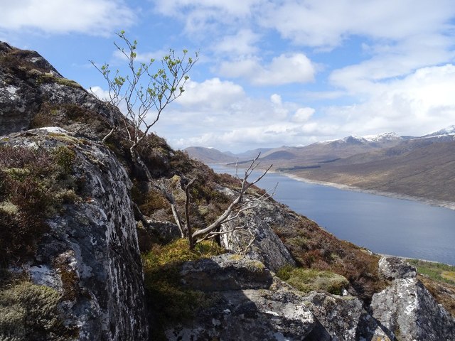
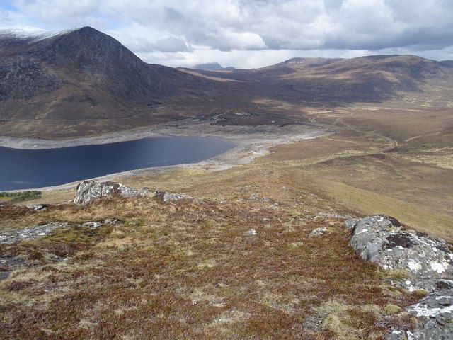
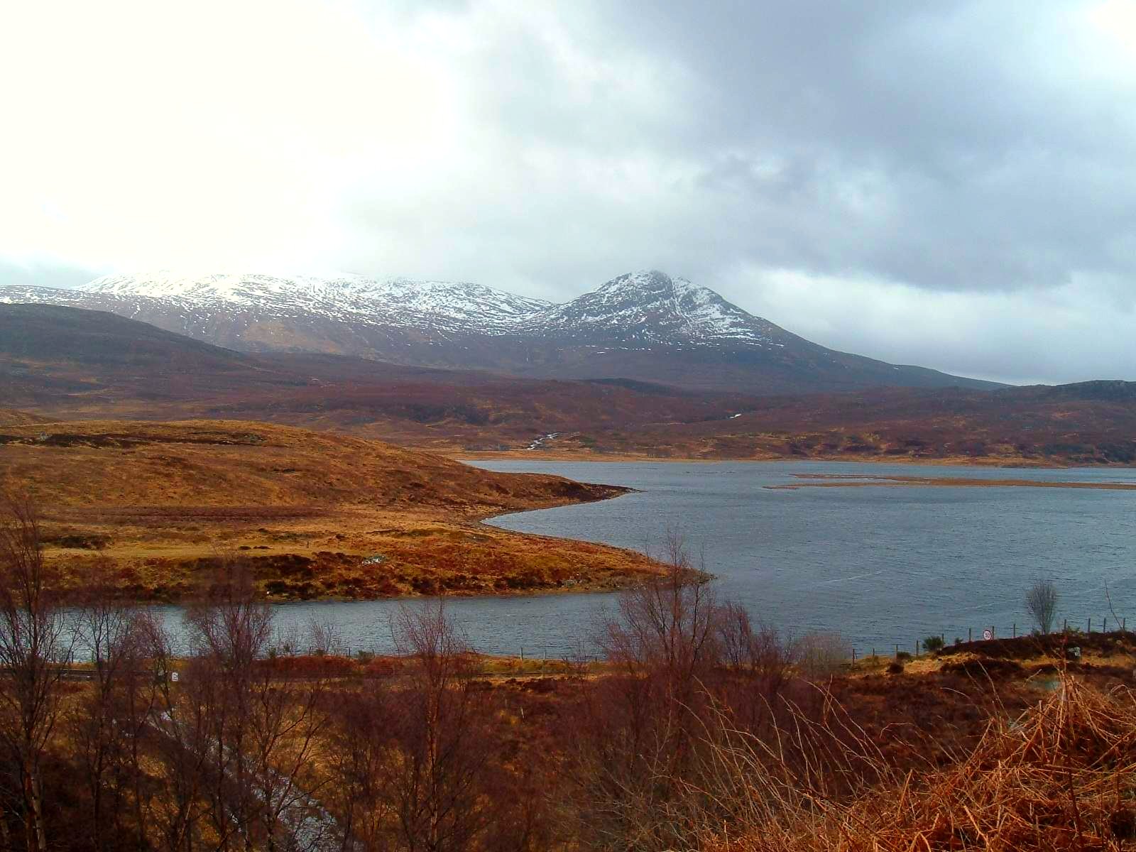
An Cabar is a prominent hill located in Ross-shire, Scotland. Rising to an elevation of 946 meters (3,104 feet), it forms part of the Fannich mountain range in the Scottish Highlands. An Cabar is situated about 20 kilometers southwest of the town of Dingwall and is easily accessible to outdoor enthusiasts.

The hill offers a challenging but rewarding climb for experienced hikers and mountaineers. Its steep slopes and rocky terrain provide a thrilling adventure, while the breathtaking views from the summit make it well worth the effort. On a clear day, one can enjoy panoramic vistas of the surrounding Fannichs, including the neighboring peaks of Sgurr Mor and Beinn Liath Mhor Fannaich.

An Cabar is rich in flora and fauna, with a variety of plant species and wildlife inhabiting its slopes. The lower slopes are covered in heather and grasses, while higher up, the landscape transforms into rugged rocks and scree. During the summer months, the hillside bursts into color with the bloom of vibrant wildflowers, creating a picturesque scene.

Due to its remote location, it is advisable for visitors to come prepared with appropriate hiking gear, including sturdy footwear and warm clothing, as weather conditions can change rapidly. It is also recommended to bring a map and compass or a GPS device to navigate the area.

Whether you're seeking a challenging hike or simply want to immerse yourself in the natural beauty of the Scottish Highlands, An Cabar offers a memorable outdoor experience.

If you have any feedback on the listing, please let us know in the comments section below.

An Cabar Images

Images are sourced within 2km of 57.63319/-4.920702 or Grid Reference NH2564. Thanks to Geograph Open Source API. All images are credited.

Road by Loch Fannich Most of the road to Fannich Lodge is smooth tarmac, but there is about 2km on rough gravel. This is the end of the gravel section.
Road by Loch Fannich
Most of the road to Fannich Lodge is smooth tarmac, but there is about 2km on rough gravel. This is the end of the gravel section.
End of Loch Fannich Low water in the loch, it is well below the level of the dam.

A similar view in 2010. <a href="https://www.geograph.org.uk/photo/2313122">NH2565 : Loch Fannich</a>
And in 2017. <a href="https://www.geograph.org.uk/photo/5405953">NH2565 : Loch Fannich after a drought</a>
End of Loch Fannich
Low water in the loch, it is well below the level of the dam. A similar view in 2010. NH2565 : Loch Fannich And in 2017. NH2565 : Loch Fannich after a drought
Moorland path by the Allt Daraich
Boat shed by Loch na Curra
Estate road to Fannich Lodge The section of the road beyond the road to the hydro facility at the south side of the loch is not surfaced with tarmac.
Estate road to Fannich Lodge
The section of the road beyond the road to the hydro facility at the south side of the loch is not surfaced with tarmac.
Loch Fannich after a drought It may seem odd to see both bare ground and grass within the dam of Loch Fannich, but this division is a consequence of the land topography before the dam was built.  My 1955 OS map shows an original shoreline that follows well the boundary between grass and bare ground.
Loch Fannich after a drought
It may seem odd to see both bare ground and grass within the dam of Loch Fannich, but this division is a consequence of the land topography before the dam was built. My 1955 OS map shows an original shoreline that follows well the boundary between grass and bare ground.
Access road to Fannich Lodge along Loch Fannich A weary mountaineer with a full rucksack of camping gear looks forward to the six mile walk out to the public highway having spent the previous night camping on the main Fannich ridge.
Access road to Fannich Lodge along Loch Fannich
A weary mountaineer with a full rucksack of camping gear looks forward to the six mile walk out to the public highway having spent the previous night camping on the main Fannich ridge.
East end of Loch Fannich The loch is drawn down and almost at its natural extent. However not all beyond the dam is water or a bare loch bed - there is peat and vegetation. Most of the dam is hardly ever used, the enlargement of the loch is entirely due to the part of the dam directly above the river.

There is a fine view down the loch towards Beinn Eighe and through a gap to Baosbheinn.
East end of Loch Fannich
The loch is drawn down and almost at its natural extent. However not all beyond the dam is water or a bare loch bed - there is peat and vegetation. Most of the dam is hardly ever used, the enlargement of the loch is entirely due to the part of the dam directly above the river. There is a fine view down the loch towards Beinn Eighe and through a gap to Baosbheinn.
Fannich Dam Much of the long low dam is never or rarely touched by impounded water, the loch enlarged by a short section directly across the River Grudie. Although Loch Fannich was drawn down to its natural dimensions, this bit is usually or always dry. A snow shower passes An Coilleachan.
Fannich Dam
Much of the long low dam is never or rarely touched by impounded water, the loch enlarged by a short section directly across the River Grudie. Although Loch Fannich was drawn down to its natural dimensions, this bit is usually or always dry. A snow shower passes An Coilleachan.
Loch Fannich A long low dam enlarged the loch, but today it was at its natural dimensions, although surrounded by unnatural bare rock and sand.
Loch Fannich
A long low dam enlarged the loch, but today it was at its natural dimensions, although surrounded by unnatural bare rock and sand.
Loch Fannich The loch is drawn down to its natural dimensions
Loch Fannich
The loch is drawn down to its natural dimensions
North side of An Cabar Moorland above the Fannich Dam.
North side of An Cabar
Moorland above the Fannich Dam.
Hydro road near Loch Fannich The tarred road serves the intake control buildings on the south shore of Loch Fannich. The background hill is Beinn Dearg (not to be confused with the big Inverlael Beinn Dearg which can also be seen from here).
Hydro road near Loch Fannich
The tarred road serves the intake control buildings on the south shore of Loch Fannich. The background hill is Beinn Dearg (not to be confused with the big Inverlael Beinn Dearg which can also be seen from here).
View along Loch Fannich Moorland on the north side of An Cabar with a view to Beinn nan Ramh at the far end of the loch. Loch Fannich is slightly enlarged for hydroelectric generation and it is drawn down to its natural dimensions here.
View along Loch Fannich
Moorland on the north side of An Cabar with a view to Beinn nan Ramh at the far end of the loch. Loch Fannich is slightly enlarged for hydroelectric generation and it is drawn down to its natural dimensions here.
Intake control buildings, Loch Fannich From below here water is taken to above Grudie where it falls to the power station there. A track continues along the lochside west of the buildings but there are a couple of annoying locked gates to negotiate.
Intake control buildings, Loch Fannich
From below here water is taken to above Grudie where it falls to the power station there. A track continues along the lochside west of the buildings but there are a couple of annoying locked gates to negotiate.
East end of Loch Fannich Drawn down to its original size, but much of the dam appears never to get used with peat and vegetation surviving inside it.
East end of Loch Fannich
Drawn down to its original size, but much of the dam appears never to get used with peat and vegetation surviving inside it.
A hardy rowan A tree making a living dodging deer at 450m. Loch Fannich stretches out into the distance.
A hardy rowan
A tree making a living dodging deer at 450m. Loch Fannich stretches out into the distance.
A rib on An Cabar A rocky rib rises from the east end of Loch Fannich and provides an easy way up An Cabar. The loch had a natural outfall, the water being drawn down below the dam and the River Grudie is leaving Loch Fannich in its pre-hydro location. There can be two Beinn Deargs visible here, the Inverlael munro one is lost in a cloud and snow shower in the gap above the loch's end while the lower Fannich one is the hill on the right.
A rib on An Cabar
A rocky rib rises from the east end of Loch Fannich and provides an easy way up An Cabar. The loch had a natural outfall, the water being drawn down below the dam and the River Grudie is leaving Loch Fannich in its pre-hydro location. There can be two Beinn Deargs visible here, the Inverlael munro one is lost in a cloud and snow shower in the gap above the loch's end while the lower Fannich one is the hill on the right.
Show me another place!

An Cabar is located at Grid Ref: NH2564 (Lat: 57.63319, Lng: -4.920702)

Unitary Authority: Highland

Police Authority: Highlands and Islands

What 3 Words

///deployed.bunkers.manicured. Near Achnasheen, Highland

Nearby Locations

An Cabar

Related Wikis

Achanalt

Achanalt (Gaelic: Achadh nan Allt) is a railway halt in Strath Bran, Ross and Cromarty, in the Scottish council area of Highland. It is served by a railway...

Achanalt railway station

Achanalt railway station is a geographically remote railway station on the Kyle of Lochalsh Line, serving the village of Achanalt in the north of Scotland...

Loch Fannich

Loch Fannich is a remote loch in Ross-shire, in Scotland. The loch is located 19 kilometres (12 mi) west of Strathpeffer. == Etymology == The name Fannich...

Grudie

Grudie (Grùididh in Scottish Gaelic) is a village, situated between Loch a' Chuilinn and Loch Luichart with the River Bran flowing past Grudie east to...

Nearby Amenities

Located within 500m of 57.63319,-4.920702
An Cabar
Corbett: no
Ele: 558.19
Graham: no
Man Made: survey_point
Marilyn: yes
Munro: no
Natural: peak
Prominence: 250
Source: OS_Opendata_Streetview
Source Ele: OS_Opendata_Streetview
Lat/Long: 57.6329415/-4.9203539
The data included in this document is from www.openstreetmap.org. The data is made available under ODbL.

Have you been to An Cabar?

Leave your review of An Cabar below (or comments, questions and feedback).