An Sìthean

Hill, Mountain in Inverness-shire

Scotland

An Sìthean

Allt Cul na Beinne The Allt Cul na Beinne is descending on the north side of Beinn na Muice soon to meet the Allt Toll a' Mhuic.
Allt Cul na Beinne Credit: Trevor Littlewood

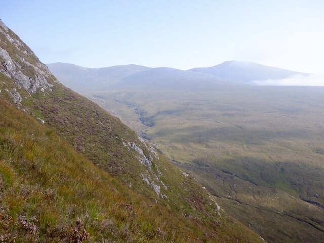
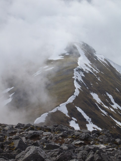
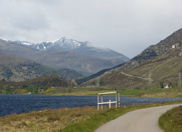
An Sìthean is a prominent hill located in Inverness-shire, Scotland. With an elevation of approximately 846 meters (2,776 feet), it is a notable part of the Scottish Highlands landscape. The hill is situated near the village of Invermoriston, offering stunning panoramic views of the surrounding area.

An Sìthean is a popular destination for outdoor enthusiasts, including hikers and climbers. Its distinctive shape and rugged terrain make it an ideal challenge for those seeking adventure. The ascent to the summit can be demanding, but the reward is a breathtaking vista of Loch Ness and the surrounding lochs, as well as the impressive Glen Moriston.

The hill is often shrouded in folklore and myths, adding to its allure. In Scottish Gaelic, "An Sìthean" translates to "The Fairy Hill," which reflects the belief that it was once a gathering place for fairies and other mythical creatures. This mystical reputation has made An Sìthean a subject of fascination for locals and visitors alike.

The area surrounding An Sìthean is teeming with wildlife and boasts a diverse ecosystem. Rare species of birds, such as golden eagles and peregrine falcons, can be spotted soaring through the skies. Additionally, the hill is home to various plant species, including heather, bracken, and Scots pine.

Overall, An Sìthean is a captivating and picturesque hill in Inverness-shire, Scotland. Its challenging ascent, panoramic views, and mythical reputation make it a must-visit destination for nature lovers and those seeking a taste of Scottish folklore.

If you have any feedback on the listing, please let us know in the comments section below.

An Sìthean Images

Images are sourced within 2km of 57.415235/-4.9203373 or Grid Reference NH2439. Thanks to Geograph Open Source API. All images are credited.

Allt Cul na Beinne The Allt Cul na Beinne is descending on the north side of Beinn na Muice soon to meet the Allt Toll a' Mhuic.
Allt Cul na Beinne
The Allt Cul na Beinne is descending on the north side of Beinn na Muice soon to meet the Allt Toll a' Mhuic.
Path beside Allt Toll a' Mhuic The Allt Toll a' Mhuic is flowing down to Glen Strathfarrar with presumably a stalkers' path beside it; the route is much used by hillwalkers embarking upon a traverse of the 'Strathfarrar Four': Munros on the north side of the glen.
Path beside Allt Toll a' Mhuic
The Allt Toll a' Mhuic is flowing down to Glen Strathfarrar with presumably a stalkers' path beside it; the route is much used by hillwalkers embarking upon a traverse of the 'Strathfarrar Four': Munros on the north side of the glen.
Landslip repairs, Allt Toll a' Mhuic The track is cut into a steep wall of a gorge and has been repaired here in the past.
Landslip repairs, Allt Toll a' Mhuic
The track is cut into a steep wall of a gorge and has been repaired here in the past.
Track, Allt Toll a' Mhuic
Moorland above Strathfarrar Early morning cloud is evaporating, slowly revealing the surrounding hills.
Moorland above Strathfarrar
Early morning cloud is evaporating, slowly revealing the surrounding hills.
East ridge, Beinn na Muice Very steep ground which was easily ascended, aided by dry ground. Cloud is evaporating and revealing Sgùrr a' Choire Glais.
East ridge, Beinn na Muice
Very steep ground which was easily ascended, aided by dry ground. Cloud is evaporating and revealing Sgùrr a' Choire Glais.
Allt Toll a' Mhuic View off the very steep Beinn na Muice to the bridge above the falls.
Allt Toll a' Mhuic
View off the very steep Beinn na Muice to the bridge above the falls.
East ridge, Beinn na Muice Towards the top of the very steep section of the ascent and looking over a wide easy angled gully towards the crags of Sgùrr na Muice.
East ridge, Beinn na Muice
Towards the top of the very steep section of the ascent and looking over a wide easy angled gully towards the crags of Sgùrr na Muice.
Allt Toll a' Mhuic Burn accompanied by a vehicle track.
Allt Toll a' Mhuic
Burn accompanied by a vehicle track.
Allt Toll a' Mhuic A lively burn with some good swimming holes. Sgùrr a' Mhuic forms the backdrop.
Allt Toll a' Mhuic
A lively burn with some good swimming holes. Sgùrr a' Mhuic forms the backdrop.
Allt Toll a' Mhuic track The usual route to Sgùrr na Fearstaig and the neighbouring munros passing Sgùrr na Muice.
Allt Toll a' Mhuic track
The usual route to Sgùrr na Fearstaig and the neighbouring munros passing Sgùrr na Muice.
Bridge over the Allt Toll a' Mhuic
Eas na Muice Waterfall at the head of a gorge on the Allt Toll a' Mhuic.
Eas na Muice
Waterfall at the head of a gorge on the Allt Toll a' Mhuic.
Eas na Muice In spate on this occasion, following heavy rain.
Eas na Muice
In spate on this occasion, following heavy rain.
Bridge, Allt Toll a' Mhuic A useful alternative to the stepping stones higher up <a href="https://www.geograph.org.uk/photo/559696">NH2341 : Stepping stones, Allt Toll a' Mhuic</a> when the burn is in spate.
Bridge, Allt Toll a' Mhuic
A useful alternative to the stepping stones higher up NH2341 : Stepping stones, Allt Toll a' Mhuic when the burn is in spate.
Eas na Muice A waterfall at the divide between the flatter upper coire and the ravine which drops fairly steeply to the glen. For a view of the fall in spate see <a href="https://www.geograph.org.uk/photo/559685">NH2340 : Eas na Muice</a>.
Eas na Muice
A waterfall at the divide between the flatter upper coire and the ravine which drops fairly steeply to the glen. For a view of the fall in spate see NH2340 : Eas na Muice.
The Eas na Muice This waterfall on the Allt Toll a' Mhuic lies on the boundary between the open moorland above and the steep slopes down to Glen Strathfarrar, down which the stream plunges in something of a ravine.
The Eas na Muice
This waterfall on the Allt Toll a' Mhuic lies on the boundary between the open moorland above and the steep slopes down to Glen Strathfarrar, down which the stream plunges in something of a ravine.
S Ridge, Meall a' Gheur-fheadain A broad ridge of grass, peat hags, and rock.
S Ridge, Meall a' Gheur-fheadain
A broad ridge of grass, peat hags, and rock.
Show me another place!

An Sìthean is located at Grid Ref: NH2439 (Lat: 57.415235, Lng: -4.9203373)

Unitary Authority: Highland

Police Authority: Highlands and Islands

What 3 Words

///snowstorm.typhoon.grid. Near Cannich, Highland

Nearby Locations

An Sìthean

Related Wikis

Sgùrr a' Choire Ghlais

Sgurr a' Choire Ghlais is a mountain in the North-west Highlands of Scotland. It lies between Glen Strathfarrar and Glen Orrin and it is an excellent viewpoint...

Càrn nan Gobhar (Strathfarrar)

Càrn nan Gobhar is a mountain rising to 992 metres (3,255 ft) in the Northwest Highlands of Scotland. It lies north of Glen Strathfarrar and south of Glen...

Glen Strathfarrar

Glen Strathfarrar (Scottish Gaelic: Srath Farair) is a glen in the Highland region of Scotland, near Loch Ness. The Glen is part of the Affric-Beauly hydro...

Sgorr na Dìollaid

Sgorr na Dìollaid is a mountain in the Northwest Highlands of Scotland. It is situated between Glen Strathfarrar and Glen Cannich, 7 km north-west of the...

Have you been to An Sìthean?

Leave your review of An Sìthean below (or comments, questions and feedback).