Barlockhart Fell

Hill, Mountain in Wigtownshire

Scotland

Barlockhart Fell

New Square at Glenluce On the corner of Church Street and Main Street.
New Square at Glenluce Credit: Billy McCrorie

Barlockhart Fell is a prominent hill located in the region of Wigtownshire, Dumfries and Galloway, in southwestern Scotland. Rising to an elevation of approximately 437 meters (1,434 feet), it is considered a significant landmark in the area.

The hill is characterized by its rugged terrain, with steep slopes covered in heather and grassland. At its summit, visitors can enjoy breathtaking panoramic views of the surrounding countryside, including the nearby Galloway Forest Park and the picturesque Solway Firth. On clear days, it is even possible to catch a glimpse of the Isle of Man in the distance.

Barlockhart Fell is a popular destination for outdoor enthusiasts and hikers, who are drawn to its natural beauty and the challenging trails it offers. There are several well-marked paths that lead to the summit, varying in difficulty to accommodate different skill levels. Along the way, walkers can encounter a diverse range of wildlife, such as red deer, buzzards, and various species of wildflowers.

The hill is also of historical significance, with remnants of ancient settlements and prehistoric sites scattered throughout its slopes. These archaeological remains provide a glimpse into the area's rich past and have attracted the interest of researchers and history enthusiasts alike.

Overall, Barlockhart Fell offers a captivating blend of natural beauty, outdoor adventure, and cultural heritage, making it a must-visit destination for those exploring Wigtownshire.

If you have any feedback on the listing, please let us know in the comments section below.

Barlockhart Fell Images

Images are sourced within 2km of 54.873968/-4.7993131 or Grid Reference NX2056. Thanks to Geograph Open Source API. All images are credited.

New Square at Glenluce On the corner of Church Street and Main Street.
New Square at Glenluce
On the corner of Church Street and Main Street.
Church Street, Glenluce Viewed from Main Street.
Church Street, Glenluce
Viewed from Main Street.
Main Street, Glenluce Viewed from the junction with Bankfield Road.
Main Street, Glenluce
Viewed from the junction with Bankfield Road.
Main Street, Glenluce From the junction with Bankfield Road.
Main Street, Glenluce
From the junction with Bankfield Road.
Bankfield Road, Glenluce Viewed from the Main Street.
Bankfield Road, Glenluce
Viewed from the Main Street.
New Square, Glenluce The bottom tier viewed from Main Street.
New Square, Glenluce
The bottom tier viewed from Main Street.
Shelter at the New Square Glenluce Located on the corner of Church Street and the Main Street.
Shelter at the New Square Glenluce
Located on the corner of Church Street and the Main Street.
New Square, Glenluce Up at the second tier.
New Square, Glenluce
Up at the second tier.
New Square, Glenluce Up at the top tier.
New Square, Glenluce
Up at the top tier.
New Square, Glenluce At the top tier looking down towards the Main Street.
New Square, Glenluce
At the top tier looking down towards the Main Street.
Shelter at the New Square, Glenluce Looking down from the top tier towards Main Street.
Shelter at the New Square, Glenluce
Looking down from the top tier towards Main Street.
New Square, Glenluce Steps up to the top tier.
New Square, Glenluce
Steps up to the top tier.
Bridge over Lady Burn, Glenluce On Bankfield Road.
Bridge over Lady Burn, Glenluce
On Bankfield Road.
Bankfield Road, Glenluce Leading to Main Street.
Bankfield Road, Glenluce
Leading to Main Street.
Lady Burn, Glenluce Viewed from the road bridge on Bankfield Road.
Lady Burn, Glenluce
Viewed from the road bridge on Bankfield Road.
Lady Burn, Glenluce Viewed from the road bridge on Bankfield Road.
Lady Burn, Glenluce
Viewed from the road bridge on Bankfield Road.
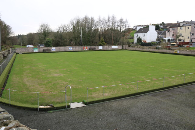
Bowling Green, Glenluce Viewed from School Road.
Bowling Green, Glenluce
Viewed from School Road.
Glenluce Bowling Club Viewed from School Road.
Glenluce Bowling Club
Viewed from School Road.
Show me another place!

Barlockhart Fell is located at Grid Ref: NX2056 (Lat: 54.873968, Lng: -4.7993131)

Unitary Authority: Dumfries and Galloway

Police Authority: Dumfries and Galloway

What 3 Words

///grief.sheepish.outgrown. Near Stranraer, Dumfries & Galloway

Related Wikis

Old Luce

Old Luce is a civil parish in Dumfries and Galloway, Scotland. It lies in the Machars peninsula, in the traditional county of Wigtownshire. The parish...

Glenluce

Glenluce (Scottish Gaelic: Clachan Ghlinn Lus) is a small village in the parish of Old Luce in Wigtownshire, Scotland.It contains a village shop,a caravan...

Glenluce railway station

Glenluce station was a station open in 1862 on the former Port Road that was constructed on the Portpatrick and Wigtownshire Joint Railway. It served the...

Castle of Park

The Castle of Park is a 16th-century L-plan tower house near Glenluce, in the historic county of Wigtownshire in Dumfries and Galloway, Scotland. It...

Nearby Amenities

Located within 500m of 54.873968,-4.7993131
Power: pole
Lat/Long: 54.8704496/-4.7960217
Power: pole
Lat/Long: 54.8708642/-4.7972537
Power: pole
Lat/Long: 54.8712631/-4.7984456
Power: pole
Lat/Long: 54.8716364/-4.7995361
Power: pole
Lat/Long: 54.8720049/-4.8006541
Power: pole
Lat/Long: 54.8723745/-4.8017593
Power: pole
Lat/Long: 54.8727274/-4.8028096
Power: pole
Lat/Long: 54.8731443/-4.8040502
Power: pole
Lat/Long: 54.874021/-4.8043587
Power: pole
Lat/Long: 54.8748162/-4.804587
Power: pole
Lat/Long: 54.8755859/-4.8048342
Power: pole
Lat/Long: 54.8762826/-4.8050794
Power: pole
Lat/Long: 54.8768468/-4.8053118
Power: pole
Lat/Long: 54.8711986/-4.7952249
Power: pole
Lat/Long: 54.8718869/-4.7944832
Power: pole
Lat/Long: 54.87276/-4.7939781
Power: pole
Lat/Long: 54.8735091/-4.7935089
Power: pole
Lat/Long: 54.8742557/-4.7930313
Power: pole
Lat/Long: 54.8749816/-4.792541
Power: pole
Lat/Long: 54.8755652/-4.7920359
Power: pole
Lat/Long: 54.872197/-4.8032704
Power: pole
Lat/Long: 54.8724645/-4.8030358
Power: pole
Lat/Long: 54.8732999/-4.8025983
Power: pole
Lat/Long: 54.8739249/-4.8023891
Power: pole
Lat/Long: 54.874528/-4.8021672
Man Made: mast
Tower Type: communication
Lat/Long: 54.8750156/-4.8012976
The data included in this document is from www.openstreetmap.org. The data is made available under ODbL.

Have you been to Barlockhart Fell?

Leave your review of Barlockhart Fell below (or comments, questions and feedback).