Am Bodach

Hill, Mountain in Argyllshire

Scotland

Am Bodach

Glen Coe car park With orientation and information point.
Glen Coe car park Credit: Chris Morgan

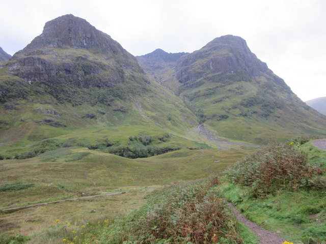
Am Bodach is a prominent hill located in Argyllshire, Scotland. Situated in the southern part of the county, it forms part of the Mamores range, which is renowned for its stunning natural beauty and challenging hikes. The hill stands at an impressive height of 1,034 meters (3,392 feet), making it one of the prominent peaks in the area.

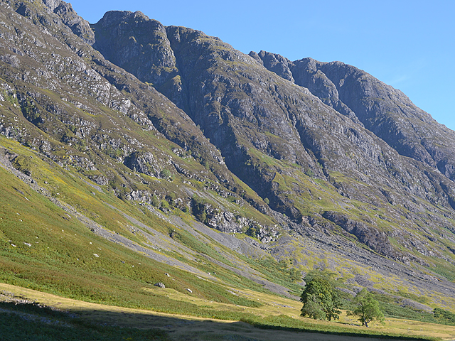
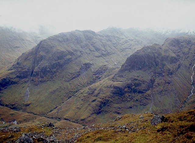
Am Bodach is characterized by its distinctive pyramid-shaped summit, which offers breathtaking panoramic views of the surrounding landscape. On a clear day, visitors can enjoy vistas of Loch Leven, Loch Linnhe, and the nearby peaks of the Mamores range. The hill is surrounded by rugged terrain, with steep slopes and rocky outcrops, making it a popular destination for experienced hikers and mountaineers.

The ascent of Am Bodach is typically approached from the Kinlochleven side, where a well-defined path leads climbers up the mountain. The hike is considered challenging, with sections of scrambling required near the summit. However, the rewarding views and sense of accomplishment make it a worthwhile endeavor for outdoor enthusiasts.

The hill is also known for its rich biodiversity, with a variety of plant and animal species thriving in its diverse habitats. Visitors may spot native wildlife such as red deer, mountain hares, and golden eagles during their ascent.

Overall, Am Bodach offers a thrilling outdoor experience for those seeking adventure and natural beauty. Its imposing presence, stunning views, and challenging terrain make it a popular destination for hillwalkers and mountaineers in Argyllshire.

If you have any feedback on the listing, please let us know in the comments section below.

Am Bodach Images

Images are sourced within 2km of 56.677921/-4.9914355 or Grid Reference NN1658. Thanks to Geograph Open Source API. All images are credited.

Glen Coe car park With orientation and information point.
Glen Coe car park
With orientation and information point.
Looking towards Three Sisters at head of Glen Coe
The Three Sisters of Glencoe This small path is the start of the walk to the Three Sisters of Glencoe.
The Three Sisters of Glencoe
This small path is the start of the walk to the Three Sisters of Glencoe.
Pass of Glencoe
Pass of Glencoe
The Three Sisters, Glencoe On the south of the pass.
The Three Sisters, Glencoe
On the south of the pass.
Towards the top of Glen Coe looking east The Old Military Road clearly still visible below
Towards the top of Glen Coe looking east
The Old Military Road clearly still visible below
The north wall of Glencoe As the southern side of the great Aonach Eagach ridge is sometimes and aptly referred to.
The north wall of Glencoe
As the southern side of the great Aonach Eagach ridge is sometimes and aptly referred to.
Meeting of the Three Waters The name the Ordnance Survey have given to the symmetrical confluence of the streams Allt Doire-bheith and Allt Coire Gabhail with the River Coe. The Allt Coire Gabhai is hidden to the right as is the arm of the River Coe lower left. Upper left is the River Coe and the small stream upper right is the Allt Doire-bheith. On a map (and presumably from the air) the confluence resembles the Scottish Saltire.
Meeting of the Three Waters
The name the Ordnance Survey have given to the symmetrical confluence of the streams Allt Doire-bheith and Allt Coire Gabhail with the River Coe. The Allt Coire Gabhai is hidden to the right as is the arm of the River Coe lower left. Upper left is the River Coe and the small stream upper right is the Allt Doire-bheith. On a map (and presumably from the air) the confluence resembles the Scottish Saltire.
What would Percy Unna have made of this? The Dalness Estate was given to the National Trust for Scotland in 1937 by the Scottish Mountaineering Council from monies raised substantially by its President, Percy Unna (1878 - 1950). In doing so he formulated Unna's Rules, which were supposed to ensure the estate was to remain undeveloped. In particular he said "that the hills should not be made easier or safer to climb" and "that ... paths should not be extended or improved".

So what would he have made of these galvanised steel posts and cable complete with red reflectors on the descent down to the wooden footbridge bridge crossing the River Coe?
What would Percy Unna have made of this?
The Dalness Estate was given to the National Trust for Scotland in 1937 by the Scottish Mountaineering Council from monies raised substantially by its President, Percy Unna (1878 - 1950). In doing so he formulated Unna's Rules, which were supposed to ensure the estate was to remain undeveloped. In particular he said "that the hills should not be made easier or safer to climb" and "that ... paths should not be extended or improved". So what would he have made of these galvanised steel posts and cable complete with red reflectors on the descent down to the wooden footbridge bridge crossing the River Coe?
What would Percy Unna have made of this? The Dalness Estate was given to the National Trust for Scotland in 1937 by the Scottish Mountaineering Council from monies raised substantially by its President, Percy Unna (1878 - 1950). In doing so he formulated Unna's Rules, which were supposed to ensure the estate was to remain undeveloped. In particular he said "that the hills should not be made easier or safer to climb" and "that ... paths should not be extended or improved".

So what would he have made of these galvanised steel handrail on the descent down to the wooden footbridge bridge crossing the River Coe?
What would Percy Unna have made of this?
The Dalness Estate was given to the National Trust for Scotland in 1937 by the Scottish Mountaineering Council from monies raised substantially by its President, Percy Unna (1878 - 1950). In doing so he formulated Unna's Rules, which were supposed to ensure the estate was to remain undeveloped. In particular he said "that the hills should not be made easier or safer to climb" and "that ... paths should not be extended or improved". So what would he have made of these galvanised steel handrail on the descent down to the wooden footbridge bridge crossing the River Coe?
The old road up Glen Coe Before the modern A82 was built.
The old road up Glen Coe
Before the modern A82 was built.
Retaining wall to the old road up Glen Coe
View from Coire nan Lochan A view towards the A82 running through the Pass of Glencoe. The image was taken from a track leading to Coire nan Lochan, used for access to Bidean nam Bian.
View from Coire nan Lochan
A view towards the A82 running through the Pass of Glencoe. The image was taken from a track leading to Coire nan Lochan, used for access to Bidean nam Bian.
Pass of Glen Coe Looking over the River Coe from a viewpoint on the A82.
Pass of Glen Coe
Looking over the River Coe from a viewpoint on the A82.
Pass of Glen Coe Looking along the Pass of Glen Coe forming the route of the A82.
Pass of Glen Coe
Looking along the Pass of Glen Coe forming the route of the A82.
Glen Coe Looking along the Pass of Glen Coe with the River Coe running in the base of the valley.
Glen Coe
Looking along the Pass of Glen Coe with the River Coe running in the base of the valley.
Glen Coe & River Coe A wider perspective (and change in season) from <a href="https://www.geograph.org.uk/photo/4203863">NN1556 : Glen Coe below Achtroichtan</a>
Glen Coe & River Coe
A wider perspective (and change in season) from NN1556 : Glen Coe below Achtroichtan
Ascent of Am Bodach, Aonach Eagach Sisters of Glencoe across the glen.
Ascent of Am Bodach, Aonach Eagach
Sisters of Glencoe across the glen.
Show me another place!

Am Bodach is located at Grid Ref: NN1658 (Lat: 56.677921, Lng: -4.9914355)

Unitary Authority: Highland

Police Authority: Highlands and Islands

What 3 Words

///changed.reactions.hampers. Near Glencoe, Highland

Related Wikis

Glen Coe

Glen Coe (Scottish Gaelic: Gleann Comhann pronounced [klan̪ˠˈkʰo.ən̪ˠ]) is a glen of volcanic origins, in the Highlands of Scotland. It lies in the north...

Meeting of Three Waters

Meeting of Three Waters is a waterfall of Scotland.The waterfall is situated at the foot of the Three Sisters of Glen Coe - a popular hiking and skiing...

Coire Gabhail

Coire Gabhail (Corrie of the Bounty, or The Hollow of Capture) is a high level glen in the Bidean nam Bian mountain massif to the south of Glen Coe, Highland...

Aonach Eagach

The Aonach Eagach (Scottish Gaelic for 'notched ridge') is a large mountain ridge in the Scottish Highlands, marking the northern edge of Glen Coe. It...

Loch Achtriochtan

Loch Achtriochtan or Loch Trychardan is a small shallow freshwater loch located to the east of Glencoe village in Lochaber in the Scottish Highlands. It...

Kinlochleven

Kinlochleven () (Scottish Gaelic: Ceann Loch Lìobhann) is a village located in Lochaber, in the Scottish Highlands and lies at the eastern end of Loch...

Clachaig Inn

The Clachaig Inn is a hotel and pub in Glen Coe, Lochaber, Highland, Scotland. It is popular with walkers and climbers who come to visit the surrounding...

Pap of Glencoe

The Pap of Glencoe (Scottish Gaelic: Sgorr na Cìche) is a mountain on the northern side of Glen Coe, in the Highlands of Scotland. It lies at the western...

Nearby Amenities

Located within 500m of 56.677921,-4.9914355
Am Bodach
Corbett: no
Donald: no
Ele: 943
Graham: no
Munro: no
Natural: peak
Source: survey
Lat/Long: 56.677795/-4.9913941
The Chancellor
Place: locality
Lat/Long: 56.6788632/-4.9974069
The data included in this document is from www.openstreetmap.org. The data is made available under ODbL.

Have you been to Am Bodach?

Leave your review of Am Bodach below (or comments, questions and feedback).