An Leth-Chreag

Hill, Mountain in Ross-shire

Scotland

An Leth-Chreag

Boulders at summit area of Sròn Garbh Sròn Garbh is a peak along the east ridge of the Munro, Carn Eighe.
Beyond its bouldery summit is Sgùrr na Lapaich, one of two mountains of that name in this area.
Boulders at summit area of Sròn Garbh Credit: Trevor Littlewood

An Leth-Chreag is a prominent hill/mountain located in Ross-shire, Scotland. It is situated in the northwest part of the country, near the village of Achnasheen and just south of Loch a' Chroisg. An Leth-Chreag stands at an elevation of approximately 650 meters (2,133 feet) and is part of the Torridon Hills range.

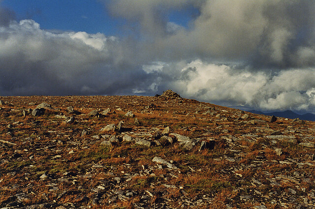
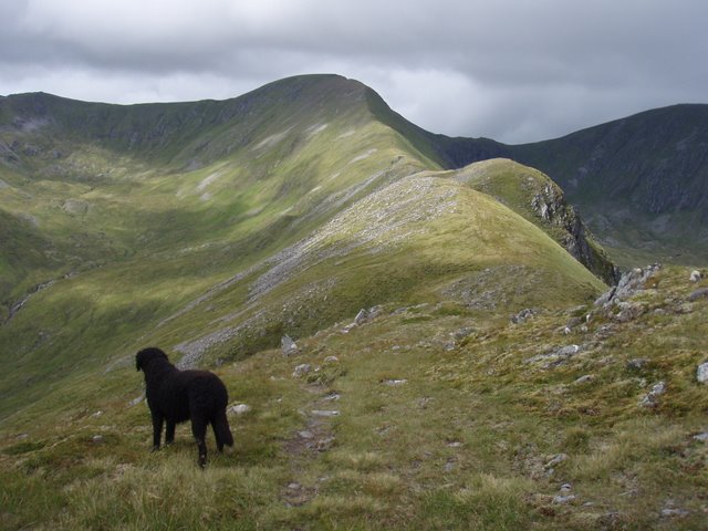
The hill/mountain is characterized by its rugged and rocky terrain, typical of the Torridon Hills. Its slopes are covered with heather and moss, interspersed with scattered boulders, making it a challenging and rewarding destination for hikers and climbers. The summit of An Leth-Chreag offers breathtaking panoramic views of the surrounding landscape, including the nearby loch and the vast wilderness of the Highlands.

Access to An Leth-Chreag is possible from various starting points, with the most common approach being from the A890 road near Achnasheen. The ascent can be demanding, with steep sections and loose scree, requiring a moderate level of fitness and navigation skills.

The hill/mountain is part of a designated nature reserve, known for its rich biodiversity. The area supports a variety of plant and animal species, including deer, mountain hares, and various bird species. It is also home to rare alpine plants that thrive in the harsh mountain environment.

In summary, An Leth-Chreag is a challenging and picturesque hill/mountain located in Ross-shire, Scotland. With its rugged terrain and stunning views, it attracts outdoor enthusiasts seeking adventure and natural beauty.

If you have any feedback on the listing, please let us know in the comments section below.

An Leth-Chreag Images

Images are sourced within 2km of 57.295882/-5.0655166 or Grid Reference NH1526. Thanks to Geograph Open Source API. All images are credited.

Boulders at summit area of Sròn Garbh Sròn Garbh is a peak along the east ridge of the Munro, Carn Eighe.
Beyond its bouldery summit is Sgùrr na Lapaich, one of two mountains of that name in this area.
Boulders at summit area of Sròn Garbh
Sròn Garbh is a peak along the east ridge of the Munro, Carn Eighe. Beyond its bouldery summit is Sgùrr na Lapaich, one of two mountains of that name in this area.
Col with ridge rising to An Leth-chreag The ridge rising from the col in shadow crosses the intermediate peak, An Leth-chreag and continues to the distant mountain, Tom a' Chòinnich. The camera location is Sròn Garbh which is an outlying, subsidiary top of  Carn Eighe.
Col with ridge rising to An Leth-chreag
The ridge rising from the col in shadow crosses the intermediate peak, An Leth-chreag and continues to the distant mountain, Tom a' Chòinnich. The camera location is Sròn Garbh which is an outlying, subsidiary top of Carn Eighe.
Loch a' Gharbh-bhealaich Loch a' Gharbh-bhealaich lies to the south of the col between two mountain tops, Sròn Garbh and An Leth-chreag, and immediately below the steep eastern face of the first of those two.
Sgùrr na Lapaich is the distant peak.
Loch a' Gharbh-bhealaich
Loch a' Gharbh-bhealaich lies to the south of the col between two mountain tops, Sròn Garbh and An Leth-chreag, and immediately below the steep eastern face of the first of those two. Sgùrr na Lapaich is the distant peak.
Southeastern slopes of Tom a’ Choinnich
Summit area of Tom a’ Choinnich
Bealach Toll Easa
Bealach Toll Easa
Pinnacle ridge between Stob a' Choire Dhomhain & Stob Coire Dhomhnuill These rock outcrops are the most cahallenging part of the ridge between Carn Eighe and Tom a' Choinich but there is a path which weaves around the pinaacles. It was unfortunate that the cloud had descended onto the whole of this ridge for our walk.
Pinnacle ridge between Stob a' Choire Dhomhain & Stob Coire Dhomhnuill
These rock outcrops are the most cahallenging part of the ridge between Carn Eighe and Tom a' Choinich but there is a path which weaves around the pinaacles. It was unfortunate that the cloud had descended onto the whole of this ridge for our walk.
Loch a' Choire Dhomhain Seen from Stob a' Choire Dhomhain. Tom a' Chòinich is the mountain beyond.
Loch a' Choire Dhomhain
Seen from Stob a' Choire Dhomhain. Tom a' Chòinich is the mountain beyond.
The north east ridge of Stob a' Choire Dhòmhain With Sgùrr na Lapaich in the distance.
The north east ridge of Stob a' Choire Dhòmhain
With Sgùrr na Lapaich in the distance.
Stob Coire Domhnuill from the west The pinnacles on the right of the picture must be bypassed, but this is fairly easy.
Stob Coire Domhnuill from the west
The pinnacles on the right of the picture must be bypassed, but this is fairly easy.
Loch a' Choire Dhomhain Seen from Stob Coire Domhnuill. Sgùrr na Lapaich is the distant mountain.
Loch a' Choire Dhomhain
Seen from Stob Coire Domhnuill. Sgùrr na Lapaich is the distant mountain.
View towards Sgùrr na Lapaich From near the edge of the gently sloping area south of the Garbh Bealach. Unsure of my route, I went over the edge and followed the stream down on nastily steep ground, and was relieved to find a horizontal deer track contouring along the slopes; this is probably the "path" shown on the map. A better route would have been to approach it from further east.
View towards Sgùrr na Lapaich
From near the edge of the gently sloping area south of the Garbh Bealach. Unsure of my route, I went over the edge and followed the stream down on nastily steep ground, and was relieved to find a horizontal deer track contouring along the slopes; this is probably the "path" shown on the map. A better route would have been to approach it from further east.
An Alpine feel to the Southeast ridge of Tom a' Choinich
Bealach Toll Easa
Bealach Toll Easa
Summit of Tom a' Chòinich
View to the head of Gleann nam Fiadh from Tom a' Chòinich With the Affric giants of Màm Sodhail and Carn Eige forming the horizon.
View to the head of Gleann nam Fiadh from Tom a' Chòinich
With the Affric giants of Màm Sodhail and Carn Eige forming the horizon.
The summit of Tom a' Chòinich Seen from the west. There is little hint from this direction of the dramatic drop off the eastern side.
The summit of Tom a' Chòinich
Seen from the west. There is little hint from this direction of the dramatic drop off the eastern side.
Stream flowing down from An Leth-chreag
Show me another place!

An Leth-Chreag is located at Grid Ref: NH1526 (Lat: 57.295882, Lng: -5.0655166)

Unitary Authority: Highland

Police Authority: Highlands and Islands

What 3 Words

///standing.breakfast.hinders. Near Cannich, Highland

Nearby Locations

An Leth-Chreag

Related Wikis

Tom a' Chòinich

Tom a' Chòinich (Scottish Gaelic: An Tom Còinnich) is a mountain in the Northwest Highlands of Scotland. It is a Munro with a height of 1,112 metres (3...

Càrn Eighe

Carn Eighe (Scottish Gaelic: Càrn Èite) is a mountain in the Northwest Highlands of Scotland. Rising to 1,183 metres (3,881 ft) above sea level, it is...

Mam Sodhail

Mam Sodhail, or Màm Sabhail in Gaelic (meaning "rounded mountain of barns"), sometimes anglicised "Mam Soul", is a mountain with a height of 1,181 metres...

Beinn Fhionnlaidh (Mullardoch)

Beinn Fhionnlaidh is a mountain in the Highlands of Scotland. It is situated on the south side of Loch Mullardoch, at the end of Glen Cannich, about 60...

Nearby Amenities

Located within 500m of 57.295882,-5.0655166
Tom a' Choinich Beag
Ele: 1032
Natural: peak
Wikidata: Q13131941
Lat/Long: 57.2989643/-5.0595046
An Leth-chreag
Ele: 1051
Natural: peak
Wikidata: Q13131945
Lat/Long: 57.2957865/-5.0658082
The data included in this document is from www.openstreetmap.org. The data is made available under ODbL.

Have you been to An Leth-Chreag?

Leave your review of An Leth-Chreag below (or comments, questions and feedback).