Bazard Hill

Hill, Mountain in Wigtownshire

Scotland

Bazard Hill

Looking Over The Main Water of Luce Dalnigap Farm on the other side.
Looking Over The Main Water of Luce Credit: Jon Alexander

Bazard Hill is a prominent hill located in the region of Wigtownshire, Scotland. Rising to an elevation of approximately 402 meters (1,319 feet), it offers breathtaking panoramic views of the surrounding landscape. The hill is situated near the village of Kirkcowan, about 8 kilometers (5 miles) to the south of Wigtown.

Bazard Hill is part of the Galloway Hills range, which is renowned for its natural beauty and diverse wildlife. The hill itself is characterized by its gentle slopes and rocky outcrops, covered in heather and grasses. Its distinct shape and prominent position make it a recognizable landmark in the area.

Hikers and outdoor enthusiasts are drawn to Bazard Hill for its scenic trails and opportunities for exploration. The ascent to the summit is relatively moderate, making it accessible to people of various fitness levels. From the top, visitors can enjoy sweeping views of the surrounding countryside, including the rolling hills, farmland, and the distant coastline.

The hill is also home to a variety of flora and fauna, adding to its natural appeal. It is not uncommon to spot native bird species, such as buzzards and red kites, soaring overhead. Additionally, the area is known for its diverse plant life, including heather, bilberry, and various wildflowers.

Overall, Bazard Hill offers an ideal setting for nature lovers and outdoor enthusiasts seeking a picturesque and rewarding experience in the heart of Wigtownshire.

If you have any feedback on the listing, please let us know in the comments section below.

Bazard Hill Images

Images are sourced within 2km of 54.990711/-4.9012821 or Grid Reference NX1470. Thanks to Geograph Open Source API. All images are credited.
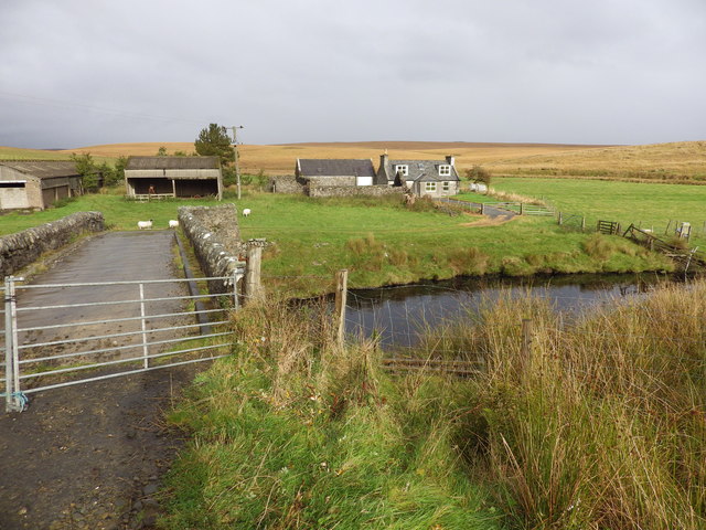
Looking Over The Main Water of Luce Dalnigap Farm on the other side.
Looking Over The Main Water of Luce
Dalnigap Farm on the other side.
Moorland off the New Luce to Penwhirn road
Penwhirn Filter Station Established in 1955 (although the buildings in view are newer than that) in conjunction with the Penwhirn Reservoir to supply water to the Stranraer district.
Penwhirn Filter Station
Established in 1955 (although the buildings in view are newer than that) in conjunction with the Penwhirn Reservoir to supply water to the Stranraer district.
Main Water of Luce Defunct bridge was shown as open on the 1995 Landranger map.
Main Water of Luce
Defunct bridge was shown as open on the 1995 Landranger map.
High Mark, near Stranraer This former farmhouse is now a holiday cottage.
High Mark, near Stranraer
This former farmhouse is now a holiday cottage.
Dalnigap Farm, near Stranraer
Penwhirn Reservoir Constructed in the 1950s to supply the Stranraer district with drinking water. Extensive forestry plantations extend from the northern shore.
Penwhirn Reservoir
Constructed in the 1950s to supply the Stranraer district with drinking water. Extensive forestry plantations extend from the northern shore.
Moorland road from New Luce to Penwhirn
Wash water holding tanks at Penwhirn Part of the installation below Penwhirn Reservoir to supply the Stranraer district with drinking water.
Wash water holding tanks at Penwhirn
Part of the installation below Penwhirn Reservoir to supply the Stranraer district with drinking water.
Bridge over Penwhirn Burn Just below Penwhirn Reservoir. The road to the right follows the Water of Luce to terminate at Lagafater Lodge [<a href="https://www.geograph.org.uk/gridref/NX1376">NX1376</a>].
Bridge over Penwhirn Burn
Just below Penwhirn Reservoir. The road to the right follows the Water of Luce to terminate at Lagafater Lodge [NX1376].
Monumental architecture at Penwhirn Filter Station Built in 1955 to provide the Stranraer district with drinking water.
Monumental architecture at Penwhirn Filter Station
Built in 1955 to provide the Stranraer district with drinking water.
Old roadside quarry near Pularyan
Excavations at Pularyan Not too sure what is going on here.
Excavations at Pularyan
Not too sure what is going on here.
Forest road with brussels sprouts Lying on the side of this forest track was a scattering of brussels sprouts. Their reason for being there may be connected to the well hidden deer shooting platform just visible to the right of centre - presumably they are deer bait.
Forest road with brussels sprouts
Lying on the side of this forest track was a scattering of brussels sprouts. Their reason for being there may be connected to the well hidden deer shooting platform just visible to the right of centre - presumably they are deer bait.
Lichen fruiting body Lots of these colourful stalks were growing in patches in the middle of the road.
Lichen fruiting body
Lots of these colourful stalks were growing in patches in the middle of the road.
High Mark The place name "Mark" can either mean a march (or boundary), or can be derived from "merkland", being the value (one merk) of the property, paid to the feudal superior. The farm name Half Mark is a variation.
High Mark
The place name "Mark" can either mean a march (or boundary), or can be derived from "merkland", being the value (one merk) of the property, paid to the feudal superior. The farm name Half Mark is a variation.
Kilfeddar Wood A shelter belt separating the moorland from the better grazing land further downhill around Kilfeddar Farm, the wood provides some protection from the northwesterly winds.  The adjacent area of moor is named on the map as Goat Bught Knowes - the hillocks of the goat pen.
Kilfeddar Wood
A shelter belt separating the moorland from the better grazing land further downhill around Kilfeddar Farm, the wood provides some protection from the northwesterly winds. The adjacent area of moor is named on the map as Goat Bught Knowes - the hillocks of the goat pen.
Open moorland east of the Main Water of Luce The low hill partly lit in a patch of sunlight is called Altaggart (allt sagairt - the priest's burn)
Open moorland east of the Main Water of Luce
The low hill partly lit in a patch of sunlight is called Altaggart (allt sagairt - the priest's burn)
Show me another place!

Bazard Hill is located at Grid Ref: NX1470 (Lat: 54.990711, Lng: -4.9012821)

Unitary Authority: Dumfries and Galloway

Police Authority: Dumfries and Galloway

What 3 Words

///chilling.wire.statement. Near Cairnryan, Dumfries & Galloway

Nearby Locations

Bazard Hill

Related Wikis

Loups of Dalnigap

Loups of Dalnigap is a waterfall of Scotland. It sits below Dalnigap House, in the South of the Lagafater Estate. == See also == Waterfalls of Scotland...

Penwhirn Reservoir

Penwhirn Reservoir, is a reservoir in Dumfries and Galloway, Scotland, approximately 3.5 miles (6 km) east of Cairnryan. The reservoir was built in the...

Glenwhilly railway station

Glenwhilly railway station served the area of Glenwhilly, Dumfries and Galloway, Scotland from 1887 to 1965 on the Girvan and Portpatrick Junction Railway...

Inch, Dumfries and Galloway

Inch is a civil parish in Dumfries and Galloway, southwest Scotland. It lies on the shore of Loch Ryan, in the traditional county of Wigtownshire.The...

Nearby Amenities

Located within 500m of 54.990711,-4.9012821
Bazard Hill
Place: locality
Source: OSODSV
Lat/Long: 54.9890433/-4.9017759
The data included in this document is from www.openstreetmap.org. The data is made available under ODbL.

Have you been to Bazard Hill?

Leave your review of Bazard Hill below (or comments, questions and feedback).