Carn Goedog

Hill, Mountain in Pembrokeshire

Wales

Carn Goedog

Cerrigmarchogion rock outcrops A line of rock outcrops of non-spotted dolerite in Pembrokeshire <span class="nowrap"><a title="https://www.megalithic.co.uk/article.php?sid=35338" rel="nofollow ugc noopener" href="https://www.megalithic.co.uk/article.php?sid=35338">Link</a><img style="margin-left:2px;" alt="External link" title="External link - shift click to open in new window" src="https://s1.geograph.org.uk/img/external.png" width="10" height="10"/></span>
Cerrigmarchogion rock outcrops Credit: Sandy Gerrard

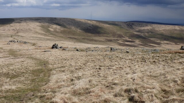
Carn Goedog is a prominent hill located in the county of Pembrokeshire, Wales. Situated in the westernmost part of the country, this hill is a part of the Preseli Hills range, renowned for its rugged beauty and historical significance. Rising to a height of approximately 370 meters (1,214 feet), Carn Goedog offers stunning panoramic views of the surrounding countryside.

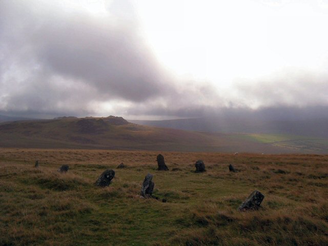
The hill is characterized by its distinctive rocky outcrops, which are made up of a bluestone known as dolerite. These bluestones have played a significant role in British history, as they were believed to have been used in the construction of Stonehenge, a prehistoric monument located in Wiltshire, England. Recent archaeological excavations have confirmed that Carn Goedog was indeed one of the quarries where these bluestones were extracted from, making it an important site for researchers and history enthusiasts alike.

Aside from its historical significance, Carn Goedog is also a popular destination for outdoor enthusiasts and hikers. The hill offers several walking trails, ranging from leisurely strolls to more challenging hikes, allowing visitors to explore its diverse flora and fauna. The surrounding area is also home to a variety of wildlife, including red kites, buzzards, and the elusive peregrine falcon.

Overall, Carn Goedog is a fascinating and picturesque hill in Pembrokeshire, offering not only breathtaking views but also a glimpse into the ancient past of Britain. Whether one is interested in history, nature, or simply seeking a peaceful retreat, this hill is a must-visit destination for anyone exploring the region.

If you have any feedback on the listing, please let us know in the comments section below.

Carn Goedog Images

Images are sourced within 2km of 51.965339/-4.7251904 or Grid Reference SN1233. Thanks to Geograph Open Source API. All images are credited.

Cerrigmarchogion rock outcrops A line of rock outcrops of non-spotted dolerite in Pembrokeshire <span class="nowrap"><a title="https://www.megalithic.co.uk/article.php?sid=35338" rel="nofollow ugc noopener" href="https://www.megalithic.co.uk/article.php?sid=35338">Link</a><img style="margin-left:2px;" alt="External link" title="External link - shift click to open in new window" src="https://s1.geograph.org.uk/img/external.png" width="10" height="10"/></span>
Cerrigmarchogion rock outcrops
A line of rock outcrops of non-spotted dolerite in Pembrokeshire LinkExternal link
Ordnance Survey Cut Mark This OS cut mark can be found on the gatepost NE side of the track. It marks a point 908.7ft above mean sea level.
Ordnance Survey Cut Mark
This OS cut mark can be found on the gatepost NE side of the track. It marks a point 908.7ft above mean sea level.
Ordnance Survey Cut Mark This OS cut mark can be found on the gatepost NE side of the track. It marks a point 887.9ft above mean sea level.
Ordnance Survey Cut Mark
This OS cut mark can be found on the gatepost NE side of the track. It marks a point 887.9ft above mean sea level.
Carn Menyn Cairn or Coetan Arthur A circular disturbed cairn 15m in diameter by 1.5m high. The capstone is 2.8m by 2.5m.
Carn Menyn Cairn or Coetan Arthur
A circular disturbed cairn 15m in diameter by 1.5m high. The capstone is 2.8m by 2.5m.
Carn Ddafad Las
Carn Ddafad Las
Remains of an old sheepfold Sheepfold in the lee of a rocky outcrop. Llethrmawr forestry beyond.
Remains of an old sheepfold
Sheepfold in the lee of a rocky outcrop. Llethrmawr forestry beyond.
Rocky outcrop near Carn Gyfrwy
Rocky outcrop in the Preseli hills
Skies and rocks - the Preseli landscape
Carn Gyfrwy
Carn Gyfrwy
A bed of bilberries An afternoon rest on a bed of bilberries below Carn Menyn.
A bed of bilberries
An afternoon rest on a bed of bilberries below Carn Menyn.
Preseli skies The sky mattered to the prehistoric people who lived and worshipped on these hills. 

Carn Menyn near left; Carn Sian and Carn Bica on the horizon.
Preseli skies
The sky mattered to the prehistoric people who lived and worshipped on these hills. Carn Menyn near left; Carn Sian and Carn Bica on the horizon.
Carn Menyn Viewed from my resting place among the bilberries.
Carn Menyn
Viewed from my resting place among the bilberries.
Cairn near Carn Gwr
Cairn near Carn Gwr
Carn Menyn Viewed from a northerly direction.
Carn Menyn
Viewed from a northerly direction.
Unnamed carn between Carn Gwr and Carn Breseb
The pinnacle of Carn Breseb
From Carn Breseb to Carn Alw Iron Age enclosure complex.

Remains of tumbled stone walls connecting natural outcrops, define a roughly triangular enclosure, about 66m north-south by 38m, backing onto the precipitous crags of Carn Alw on the east, & fronted by broad, carefully delimited zone of 'chevaux-de-frise' on the south-west & west (Mytum & Webster 1989): this prominently defined & sited enclosure appears to be the focus for an extensive complex of enclosures & associated features (cairns/clearance features & structures, rectlinear & circular/subcircular), extending about 800m north-west to south-east by 500m overall (Nprn308732, 308737: Drewett 1987).
From Carn Breseb to Carn Alw
Iron Age enclosure complex. Remains of tumbled stone walls connecting natural outcrops, define a roughly triangular enclosure, about 66m north-south by 38m, backing onto the precipitous crags of Carn Alw on the east, & fronted by broad, carefully delimited zone of 'chevaux-de-frise' on the south-west & west (Mytum & Webster 1989): this prominently defined & sited enclosure appears to be the focus for an extensive complex of enclosures & associated features (cairns/clearance features & structures, rectlinear & circular/subcircular), extending about 800m north-west to south-east by 500m overall (Nprn308732, 308737: Drewett 1987).
Show me another place!

Carn Goedog is located at Grid Ref: SN1233 (Lat: 51.965339, Lng: -4.7251904)

Unitary Authority: Pembrokeshire

Police Authority: Dyfed Powys

What 3 Words

///driven.liberated.fired. Near Crymych, Pembrokeshire

Nearby Locations

Carn Goedog

Related Wikis

Bedd Arthur

Bedd Arthur ("Arthur's Grave") is a possibly Neolithic hengiform monument megalithic site in the Preseli Hills in the Welsh county of Pembrokeshire. Thirteen...

Carn Menyn

Carn Menyn is a grouping of craggy rock outcrops or tors in the Preseli Hills in the Welsh county of Pembrokeshire. == Name and location == The name means...

Penbanc

Penbanc is a 19th-century thatched Pembrokeshire longhouse (tŷ hir in Welsh) about 1.5 kilometres (0.9 miles) northwest of the hamlet of Brynberian in...

Crosswell

Crosswell (Welsh: Ffynnon-groes) is a hamlet on the B4329 road in the community of Eglwyswrw, Pembrokeshire, Wales, in the parish of Meline. It is 7 miles...

Nearby Amenities

Located within 500m of 51.965339,-4.7251904
Carn Goedog
Natural: peak
Note: Possible source of Stonehenge bluestones.
Lat/Long: 51.9654757/-4.7252854
The data included in this document is from www.openstreetmap.org. The data is made available under ODbL.

Have you been to Carn Goedog?

Leave your review of Carn Goedog below (or comments, questions and feedback).