Braid Hill

Hill, Mountain in Ayrshire

Scotland

Braid Hill

Looking Over The Main Water of Luce Dalnigap Farm on the other side.
Looking Over The Main Water of Luce Credit: Jon Alexander

Braid Hill is a prominent landmark located in Ayrshire, Scotland. Standing at an elevation of approximately 285 meters (935 feet), it is classified as a hill rather than a mountain. The hill is situated near the town of Irvine, about 30 kilometers (19 miles) southwest of Glasgow.

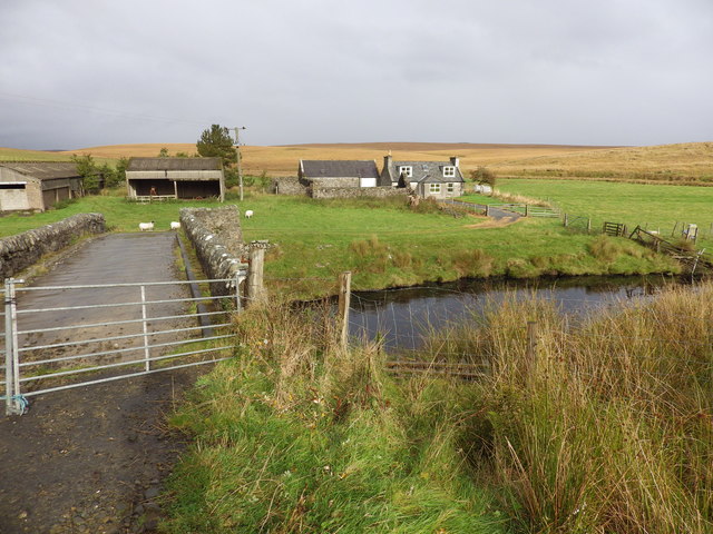
Braid Hill is renowned for its picturesque beauty and is a popular destination for nature lovers and hikers alike. The hill offers breathtaking panoramic views of the surrounding countryside, including the nearby Firth of Clyde and the Isle of Arran. On clear days, it is even possible to catch a glimpse of the Ailsa Craig, a distinctive rocky island in the Firth of Clyde.

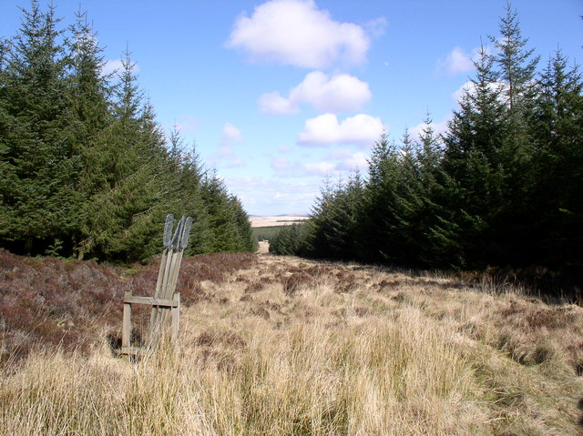
The hill is covered in lush greenery, with a mix of grasslands, heather, and scattered trees. It is home to a diverse range of wildlife, including various bird species, rabbits, and foxes. The flora and fauna on Braid Hill are protected, making it an important conservation area.

A network of well-maintained footpaths and trails allows visitors to explore the hill and enjoy its natural beauty. These paths cater to a range of abilities, from gentle strolls to more challenging hikes. Braid Hill attracts a steady stream of visitors throughout the year, with many people appreciating the tranquility and peacefulness it offers.

Overall, Braid Hill is a captivating destination that provides a unique opportunity to escape the hustle and bustle of everyday life and immerse oneself in the stunning Scottish countryside.

If you have any feedback on the listing, please let us know in the comments section below.

Braid Hill Images

Images are sourced within 2km of 55.005696/-4.9369007 or Grid Reference NX1271. Thanks to Geograph Open Source API. All images are credited.

Looking Over The Main Water of Luce Dalnigap Farm on the other side.
Looking Over The Main Water of Luce
Dalnigap Farm on the other side.
High Mark, near Stranraer This former farmhouse is now a holiday cottage.
High Mark, near Stranraer
This former farmhouse is now a holiday cottage.
Dalnigap Farm, near Stranraer
Sheepfold at Laganabeastie The notice on this small bridge reads 'Private Road. No vehicles beyond this point'
Sheepfold at Laganabeastie
The notice on this small bridge reads 'Private Road. No vehicles beyond this point'
Stone Bridge, Laganabeastie The bridge appears to have been restored recently.
Stone Bridge, Laganabeastie
The bridge appears to have been restored recently.
Sheepfold at Laganabeastie Part of extensive stone walls to do with sheep. In the background by the trees is Barnvannoch farm.
Sheepfold at Laganabeastie
Part of extensive stone walls to do with sheep. In the background by the trees is Barnvannoch farm.
Forest road with brussels sprouts Lying on the side of this forest track was a scattering of brussels sprouts. Their reason for being there may be connected to the well hidden deer shooting platform just visible to the right of centre - presumably they are deer bait.
Forest road with brussels sprouts
Lying on the side of this forest track was a scattering of brussels sprouts. Their reason for being there may be connected to the well hidden deer shooting platform just visible to the right of centre - presumably they are deer bait.
Forestry north of Penwhirn Extensive blanket conifer plantations stretching to the horizon cover the moors to the north of Penwhirn reservoir.
Forestry north of Penwhirn
Extensive blanket conifer plantations stretching to the horizon cover the moors to the north of Penwhirn reservoir.
Lichen fruiting body Lots of these colourful stalks were growing in patches in the middle of the road.
Lichen fruiting body
Lots of these colourful stalks were growing in patches in the middle of the road.
Esker near Shennas The snaking ridge is an esker, a cast of a water channel formed within a glacier by deposited sediment . This one is a few hundred yards long and originates to the north of Shennas farm, which actually sits on it. It continues as the green lump to the lower right hand side of the picture.
Esker near Shennas
The snaking ridge is an esker, a cast of a water channel formed within a glacier by deposited sediment . This one is a few hundred yards long and originates to the north of Shennas farm, which actually sits on it. It continues as the green lump to the lower right hand side of the picture.
Moorland near Barnvannoch Looking southeast over the course of the Bungsie Burn towards Grey Hill.
Moorland near Barnvannoch
Looking southeast over the course of the Bungsie Burn towards Grey Hill.
The Laganabeastie Burn Laganabeastie means either the hollow of the snake, or of the beast.
The Laganabeastie Burn
Laganabeastie means either the hollow of the snake, or of the beast.
High Mark The place name "Mark" can either mean a march (or boundary), or can be derived from "merkland", being the value (one merk) of the property, paid to the feudal superior. The farm name Half Mark is a variation.
High Mark
The place name "Mark" can either mean a march (or boundary), or can be derived from "merkland", being the value (one merk) of the property, paid to the feudal superior. The farm name Half Mark is a variation.
Moorland Wood Very small lonely wood with sheep fold
Moorland Wood
Very small lonely wood with sheep fold
Pinwhiskie Hill Lovely name for a small hill
Pinwhiskie Hill
Lovely name for a small hill
Forest Burn Unnamed burn flows towards and joins the Penwhirn burn.
Forest Burn
Unnamed burn flows towards and joins the Penwhirn burn.
Forest Firebreak With its supply of beaters.
Forest Firebreak
With its supply of beaters.
Laganabeastie Hill Open Moorland
Laganabeastie Hill
Open Moorland
Show me another place!

Braid Hill is located at Grid Ref: NX1271 (Lat: 55.005696, Lng: -4.9369007)

Unitary Authority: Dumfries and Galloway

Police Authority: Dumfries and Galloway

What 3 Words

///grow.craft.homecare. Near Cairnryan, Dumfries & Galloway

Nearby Locations

Braid Hill

Related Wikis

Loups of Dalnigap

Loups of Dalnigap is a waterfall of Scotland. It sits below Dalnigap House, in the South of the Lagafater Estate. == See also == Waterfalls of Scotland...

Penwhirn Reservoir

Penwhirn Reservoir, is a reservoir in Dumfries and Galloway, Scotland, approximately 3.5 miles (6 km) east of Cairnryan. The reservoir was built in the...

The Lagafater Estate

Lagafater is a 7000-acre (2832.8 ha) former sporting estate near New Luce in Dumfries and Galloway, Scotland. Since 1910 it has been in the family of its...

Glenwhilly railway station

Glenwhilly railway station served the area of Glenwhilly, Dumfries and Galloway, Scotland from 1887 to 1965 on the Girvan and Portpatrick Junction Railway...

Nearby Amenities

Located within 500m of 55.005696,-4.9369007
Power: pole
Lat/Long: 55.0049341/-4.929558
Power: pole
Lat/Long: 55.0056518/-4.9303245
Power: pole
Lat/Long: 55.0062971/-4.9310134
Power: pole
Lat/Long: 55.006984/-4.9317469
Power: pole
Lat/Long: 55.0075033/-4.9323014
Power: pole
Lat/Long: 55.0079475/-4.931832
Power: pole
Lat/Long: 55.0084699/-4.9312799
Barrier: cattle_grid
Lat/Long: 55.0032751/-4.9302903
The data included in this document is from www.openstreetmap.org. The data is made available under ODbL.

Have you been to Braid Hill?

Leave your review of Braid Hill below (or comments, questions and feedback).