An Cabar

Hill, Mountain in Ross-shire

Scotland

An Cabar

North-west ridge of Meall a'Chaorainn Looking to Slioch on the left.
North-west ridge of Meall a'Chaorainn Credit: Alan Reid

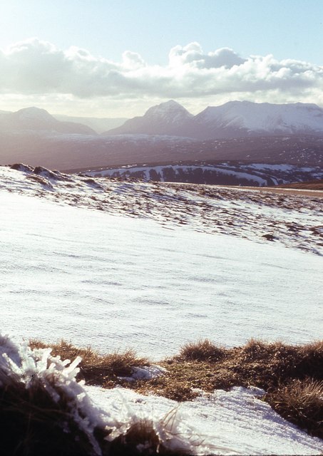
An Cabar is a prominent hill located in Ross-shire, Scotland. It sits within the wider range of hills known as the Fannichs, which are part of the Northwest Highlands. The hill stands at an elevation of 946 meters (3,104 feet) and is a popular destination for hikers and mountaineers.

An Cabar is known for its distinctive shape and rugged terrain. It is characterized by steep slopes and rocky outcrops, providing a challenging but rewarding climb for experienced adventurers. The hill is surrounded by picturesque landscapes, offering stunning views of the surrounding countryside, including nearby lochs and other mountains.

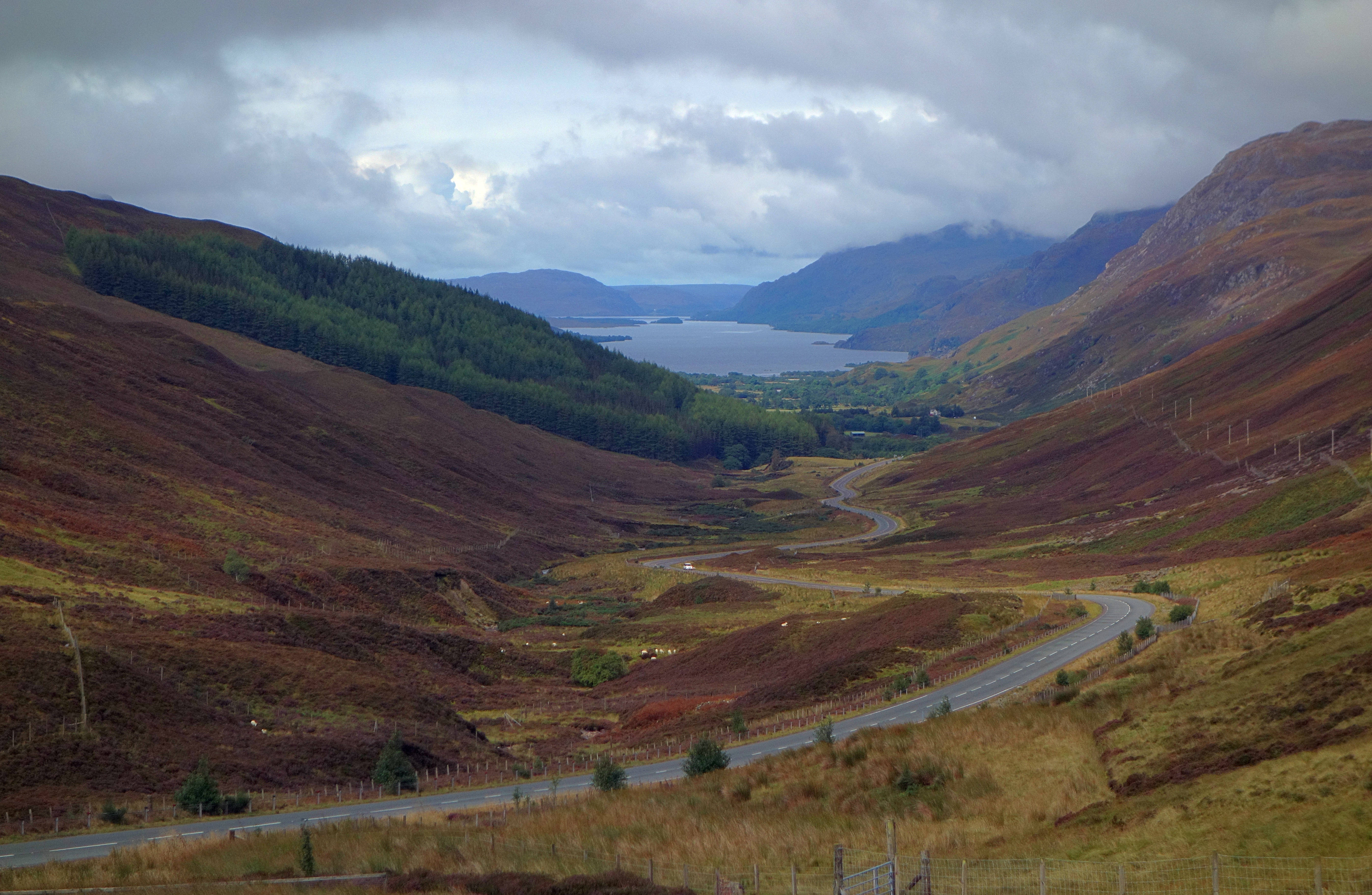
The ascent of An Cabar can be approached from various directions, with the most popular route starting from the car park at the base of the hill. The path initially meanders through a dense forest before emerging onto open moorland. From there, the climb becomes steeper as hikers make their way up the hillside, navigating rocky sections and sometimes encountering scrambling sections.

Reaching the summit of An Cabar rewards climbers with breathtaking panoramic views of the surrounding wilderness. On clear days, it is possible to see as far as the neighboring Ben Wyvis and Ben Nevis mountain ranges. The descent can be made via the same route or via alternative trails, providing opportunities for circular walks.

An Cabar offers a challenging and rewarding outdoor experience for those seeking to explore the natural beauty of the Scottish Highlands. Its unique features and stunning views make it a popular destination for hillwalkers and nature enthusiasts.

If you have any feedback on the listing, please let us know in the comments section below.

An Cabar Images

Images are sourced within 2km of 57.593912/-5.166551 or Grid Reference NH1060. Thanks to Geograph Open Source API. All images are credited.

North-west ridge of Meall a'Chaorainn Looking to Slioch on the left.
North-west ridge of Meall a'Chaorainn
Looking to Slioch on the left.
Meall a' Chaorainn snowscape Looking towards Torridon mountains.
Meall a' Chaorainn snowscape
Looking towards Torridon mountains.
Waterfall, Feadan Duchairidh A tributary burn, runs down a waterfall on the slopes of Meall a'Chaoruinn. The lower slopes of the hill are covered in deep heather, the glen of Feadan Duchairidh is mostly planted with conifers like Sitka Spruce.
Waterfall, Feadan Duchairidh
A tributary burn, runs down a waterfall on the slopes of Meall a'Chaoruinn. The lower slopes of the hill are covered in deep heather, the glen of Feadan Duchairidh is mostly planted with conifers like Sitka Spruce.
Feadan Duchairidh The path up the glen gives access for stalkers and walkers to the hills and moors around Loch Fannich.
Feadan Duchairidh
The path up the glen gives access for stalkers and walkers to the hills and moors around Loch Fannich.
The burn in Feadan Duchairidh The Allt Duchairidh carves a steep sided valley near the top of Feadan Duchairidh. One section on the far side has been too steep to hold onto its covering of peat and heather, which has been washed down into the burn.
The burn in Feadan Duchairidh
The Allt Duchairidh carves a steep sided valley near the top of Feadan Duchairidh. One section on the far side has been too steep to hold onto its covering of peat and heather, which has been washed down into the burn.
The upper reaches of the Allt Duchairidh
Path towards Loch Fannich The path becomes less distinct as it climbs out of Feadan Duchairidh to head around the western foot of Fionn Bheinn towards Loch Fannich.
Path towards Loch Fannich
The path becomes less distinct as it climbs out of Feadan Duchairidh to head around the western foot of Fionn Bheinn towards Loch Fannich.
Near the source of the Allt Duchairidh Just south of the watershed between Strath Chrombaill and Strath Bran.
Near the source of the Allt Duchairidh
Just south of the watershed between Strath Chrombaill and Strath Bran.
Soft ground north of An Cabar The sort of stuff to avoid putting a leg into.
Soft ground north of An Cabar
The sort of stuff to avoid putting a leg into.
An Cabar Looking up the north east slopes of An Cabar from the top of Feadan Duchairidh.
An Cabar
Looking up the north east slopes of An Cabar from the top of Feadan Duchairidh.
Loch a' Chroisg With Sgùrr a' Ghlas Leathaid visible in the distance.
Loch a' Chroisg
With Sgùrr a' Ghlas Leathaid visible in the distance.
The A832 along Loch a' Chroisg A new road giving a fast approach to the west. Maybe though it lacks a bit of the magic of the old single-track road, which weaved its way in and out along the shores of the loch.
The A832 along Loch a' Chroisg
A new road giving a fast approach to the west. Maybe though it lacks a bit of the magic of the old single-track road, which weaved its way in and out along the shores of the loch.
Road (A832) beside Loch a' Chroisg Looking eastward.
Road (A832) beside Loch a' Chroisg
Looking eastward.
Fence-lined road (A832) beside Loch a' Chroisg Looking westward.
Fence-lined road (A832) beside Loch a' Chroisg
Looking westward.
Badavanich Badavanich is a small house to the north of the A832 alongside Loch a' Chroisg.
The image was made in April 1990; Ian S. has an image from October 2014 which shows it after improvement - <a title="https://www.geograph.org.uk/photo/4215773" href="https://www.geograph.org.uk/photo/4215773">Link</a> .
Badavanich
Badavanich is a small house to the north of the A832 alongside Loch a' Chroisg. The image was made in April 1990; Ian S. has an image from October 2014 which shows it after improvement - Link .
Loch a' Chroisg
Loch a' Chroisg
A832 The A832 runs 127 miles from the Black Isle to Braemore Junction <a href="https://www.geograph.org.uk/photo/7232275">NH2077 : Braemore Junction</a>.
<span class="nowrap"><a title="https://www.sabre-roads.org.uk/wiki/index.php?title=A832" rel="nofollow ugc noopener" href="https://www.sabre-roads.org.uk/wiki/index.php?title=A832">Link</a><img style="margin-left:2px;" alt="External link" title="External link - shift click to open in new window" src="https://s1.geograph.org.uk/img/external.png" width="10" height="10"/></span>
A832
The A832 runs 127 miles from the Black Isle to Braemore Junction NH2077 : Braemore Junction. LinkExternal link
Show me another place!

An Cabar is located at Grid Ref: NH1060 (Lat: 57.593912, Lng: -5.166551)

Unitary Authority: Highland

Police Authority: Highlands and Islands

What 3 Words

///clocked.expose.invoices. Near Achnasheen, Highland

Nearby Locations

An Cabar

Related Wikis

Fionn Bheinn

Fionn Bheinn is a mountain located south of Loch Fannich in the northwestern Scottish Highlands. It has a height of 933 m (3061 ft) and is listed as a...

Glen Docherty

Glen Docherty (Scottish Gaelic: Gleann Dochartaich) is a glen in Wester Ross in Scotland, between Loch Maree and Kinlochewe to the west and Loch a'Chroisg...

Ledgowan Forest

Ledgowan Forest is a deer forest in the Northwest Highlands of Scotland. It stands in Wester Ross to the southwest of Achnasheen. Ledgowan Forest is the...

Achnasheen railway station

Achnasheen railway station is a remote railway station on the Kyle of Lochalsh Line, serving the village of Achnasheen in the north of Scotland. The station...

Nearby Amenities

Located within 500m of 57.593912,-5.166551
An Cabar
Natural: peak
Lat/Long: 57.5937813/-5.1667071
The data included in this document is from www.openstreetmap.org. The data is made available under ODbL.

Have you been to An Cabar?

Leave your review of An Cabar below (or comments, questions and feedback).