Càrn an Uillt Ghiuthais

Hill, Mountain in Ross-shire

Scotland

Càrn an Uillt Ghiuthais

HEP works in the valley Fionn Bheinn in the background.
HEP works in the valley Credit: Ibn Musa

Càrn an Uillt Ghiuthais, located in Ross-shire, Scotland, is a prominent hill/mountain that stands at an elevation of 895 meters (2,936 feet). It is part of the extensive mountain range known as the Northwest Highlands, which is renowned for its stunning natural beauty and rugged terrain.

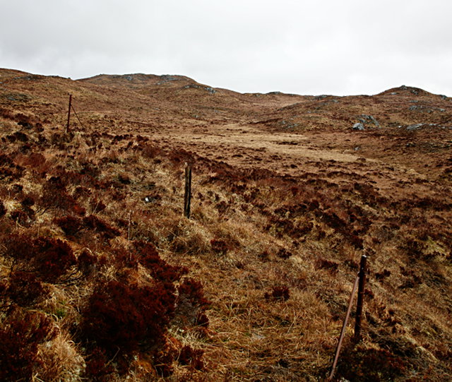
Càrn an Uillt Ghiuthais is situated within the Glen Affric National Nature Reserve, an area that is celebrated for its diverse ecosystems and rich biodiversity. The hill/mountain itself is characterized by its steep slopes and rocky outcrops, offering a challenging climb for experienced hikers and mountaineers. Its distinctive shape and commanding presence make it a prominent landmark in the region.

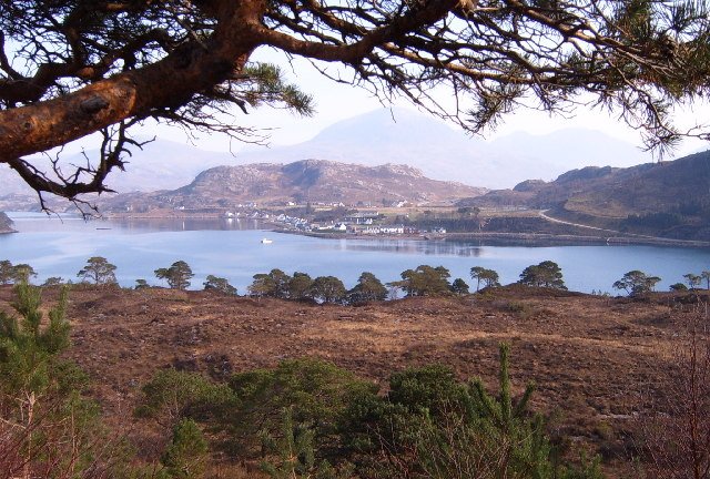
The summit of Càrn an Uillt Ghiuthais offers breathtaking panoramic views of the surrounding countryside, with vistas extending across the vast expanse of Glen Affric and its picturesque lochs. On clear days, it is possible to see as far as the iconic peaks of the Cairngorms National Park to the east, and the Isle of Skye to the west.

The hill/mountain is also home to a variety of wildlife, including red deer, golden eagles, and ptarmigan. It provides a habitat for numerous plant species, such as the rare dwarf birch and the vibrant purple saxifrage.

Càrn an Uillt Ghiuthais is a popular destination for outdoor enthusiasts seeking to immerse themselves in the stunning natural landscapes of the Scottish Highlands. Its challenging ascent, breathtaking views, and rich biodiversity make it a must-visit location for those seeking adventure and a connection with nature.

If you have any feedback on the listing, please let us know in the comments section below.

Càrn an Uillt Ghiuthais Images

Images are sourced within 2km of 57.633123/-5.2540565 or Grid Reference NH0565. Thanks to Geograph Open Source API. All images are credited.

HEP works in the valley Fionn Bheinn in the background.
HEP works in the valley
Fionn Bheinn in the background.
Un-named lochan on south slope of Beinn a' Mhùinidh There's plenty of steepness on Beinn a' Mhùinidh but much of the south side descends relatively gently over convoluted slopes with a number of lochans, of which this is one.
Beinn Eighe is the complex distant mountain at the left side of the image.
Un-named lochan on south slope of Beinn a' Mhùinidh
There's plenty of steepness on Beinn a' Mhùinidh but much of the south side descends relatively gently over convoluted slopes with a number of lochans, of which this is one. Beinn Eighe is the complex distant mountain at the left side of the image.
View north of the Heights of Kinlochewe With Fionn Bheinn poking up in the distance.
View north of the Heights of Kinlochewe
With Fionn Bheinn poking up in the distance.
Boulder strewn slopes East of Allt na h-Innse Drisich.  This area of moorland between Incheril and Heights of Kinlochewe is grazed by sheep.
Boulder strewn slopes
East of Allt na h-Innse Drisich. This area of moorland between Incheril and Heights of Kinlochewe is grazed by sheep.
Old fence This fence fell into disrepair long ago; further down the hill a new deer fence delimits Letterewe Estate native woodland regeneration.
Old fence
This fence fell into disrepair long ago; further down the hill a new deer fence delimits Letterewe Estate native woodland regeneration.
Deer fence The deer fence bounds a large area of native regeneration.
Deer fence
The deer fence bounds a large area of native regeneration.
Loch an Uillt-ghiubhais One of many small lochans scattered to the east of Beinn a' Mhùinidh.
Loch an Uillt-ghiubhais
One of many small lochans scattered to the east of Beinn a' Mhùinidh.
Small lochan The summit of Slioch, behind, looks easily accessible, but it's actually separated by the deep cut of Gleann Bianasdail.
Small lochan
The summit of Slioch, behind, looks easily accessible, but it's actually separated by the deep cut of Gleann Bianasdail.
Boggy catchment The sodden ground feeds Allt an Sgriòdain Ruaidh, and then Loch Chùilean Dubha.
Boggy catchment
The sodden ground feeds Allt an Sgriòdain Ruaidh, and then Loch Chùilean Dubha.
Bridge over the Abhainn Gleann na Muice
Looking up Gleann na Muice from the Heights of Kinlochewe
Derelict cottage
Derelict cottage
Derelict house at Heights of Kinlochewe
Bothy, Heights of Kinlochewe
Young plantation, Garbh Leathad
Track in Gleann na Muice The Caledonian pine trees on the hillside were planted in 2004
Track in Gleann na Muice
The Caledonian pine trees on the hillside were planted in 2004
Track in Gleann na Muice The track goes through the native woodland that was planted in 2004
Track in Gleann na Muice
The track goes through the native woodland that was planted in 2004
Gate at start of track to Gleann na Muice The gate and fence protect the native woodland that was planted in 2004. The notice reads

LETTEREWE ESTATE
The native woodland is centred on Abhainn Gleann na Muice and lies within an important part of the Loch Maree catchment. This riparian woodland was planted during 2004 using native Caledonian pine (local provenance) and a variety of mixed native broadleaves including Downy birch, Sessile oak, Willow, Alder, Rowan and Aspen. Broadleaves have been targeted along the edges of water courses to achieve maximum benefits regarding wild fish populations.
The use of deer fencing is seen as a relatively short-term measure to help establish this native woodland. However, the medium term objective is to remove all fencing and allow open access to the woodland. The trees establishment will help extend native woodland cover towards the much valued remnants of ancient Caledonian pinewood in the Loch Maree area and in time it is hoped will have their own high associated biodiversity value.
Gate at start of track to Gleann na Muice
The gate and fence protect the native woodland that was planted in 2004. The notice reads LETTEREWE ESTATE The native woodland is centred on Abhainn Gleann na Muice and lies within an important part of the Loch Maree catchment. This riparian woodland was planted during 2004 using native Caledonian pine (local provenance) and a variety of mixed native broadleaves including Downy birch, Sessile oak, Willow, Alder, Rowan and Aspen. Broadleaves have been targeted along the edges of water courses to achieve maximum benefits regarding wild fish populations. The use of deer fencing is seen as a relatively short-term measure to help establish this native woodland. However, the medium term objective is to remove all fencing and allow open access to the woodland. The trees establishment will help extend native woodland cover towards the much valued remnants of ancient Caledonian pinewood in the Loch Maree area and in time it is hoped will have their own high associated biodiversity value.
Show me another place!

Càrn an Uillt Ghiuthais is located at Grid Ref: NH0565 (Lat: 57.633123, Lng: -5.2540565)

Unitary Authority: Highland

Police Authority: Highlands and Islands

What 3 Words

///acrobats.surprised.himself. Near Kinlochewe, Highland

Related Wikis

Anancaun

Anancaun (Scottish Gaelic: Àth nan Ceann) is a small hamlet located in Ross-shire, Scotland, within the Scottish council area of Highland. == References ==

Wester Ross

Wester Ross (Scottish Gaelic: Ros an Iar) is an area of the Northwest Highlands of Scotland in the council area of Highland. The area is loosely defined...

Kinlochewe

Kinlochewe (Scottish Gaelic: Ceann Loch Iù or Iùbh) is a village in Wester Ross in the Northwest Highlands of Scotland. It is in the parish of Gairloch...

Cape Wrath Trail

Cape Wrath Trail is a hiking route that runs through the Scottish Highlands and along the west coast of Scotland. It is approximately 200 miles (321 km...

Nearby Amenities

Located within 500m of 57.633123,-5.2540565
Carn an Uillt-ghiubhais
Natural: peak
Note: position estimated
Lat/Long: 57.6334447/-5.2540183
The data included in this document is from www.openstreetmap.org. The data is made available under ODbL.

Have you been to Càrn an Uillt Ghiuthais?

Leave your review of Càrn an Uillt Ghiuthais below (or comments, questions and feedback).