Creag a' Chaorainn

Hill, Mountain in Ross-shire

Scotland

Creag a' Chaorainn

Inspecting Bearnais Bothy's shed
Inspecting Bearnais Bothy's shed Credit: Alan Reid

Creag a' Chaorainn is a prominent hill located in Ross-shire, Scotland. It lies within the stunning Scottish Highlands, about 12 kilometers southeast of the town of Garve. With an elevation of 1,050 meters, it is classified as a Munro, which means it is one of the many mountains in Scotland that surpasses the height of 3,000 feet.

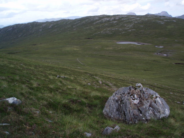
The hill is known for its distinctive shape, with a prominent cone-shaped summit that offers breathtaking panoramic views of the surrounding landscape. Its slopes are covered in heather, grasses, and scattered rocks, giving it a rugged and wild appearance.

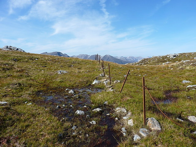
Creag a' Chaorainn is a popular destination for hikers and climbers due to its accessibility and rewarding views. There are several routes to reach the summit, varying in difficulty. The most common approach is from the northeast, starting at the Strathconon Glen and following a well-defined path that gradually ascends the hill.

Along the way, hikers can admire the diverse flora and fauna that inhabit the area. Golden eagles, red deer, and mountain hares are often spotted in the vicinity. The hill is also home to several smaller lochs, adding to the picturesque scenery.

Creag a' Chaorainn is an excellent choice for those seeking a challenging outdoor adventure or simply wishing to immerse themselves in the raw beauty of the Scottish Highlands. With its stunning vistas and rich natural surroundings, this mountain is a must-visit for outdoor enthusiasts and nature lovers alike.

If you have any feedback on the listing, please let us know in the comments section below.

Creag a' Chaorainn Images

Images are sourced within 2km of 57.440251/-5.3213287 or Grid Reference NH0043. Thanks to Geograph Open Source API. All images are credited.

Inspecting Bearnais Bothy's shed
Lonely shieling Shielings were moorland summer grazings for cattle.  Shieling huts (often also referred to as shielings) were dwellings located within the shieling.  They were usually occupied from May until the “flitting” in September.  In early May the men of a village would go onto the moor to check and repair the shieling huts.  They would be joined by the women and children for one night before the men returned to the village to tend to crops or to travel away for summer work such as fishing.  The women and children would spend the summer at the shielings tending the cattle and making cheese and butter, some of which was for immediate use but most was salted to preserve it for the winter.  Peat cutting for fuel would also be done.  Evenings would be spent making music and story telling.  Visits were made between the shielings of different villages.

The shieling huts were made from materials available in the immediate vicinity.  They usually had walls made of stone or turf, turf roofs and compacted earth or clay floors.  In coastal areas and on the islands rafters would be made from locally collected driftwood.  Usually there would be a single doorway, facing away from the prevailing wind (although some shieling huts have two doors opposite each other), and often no windows.  Furniture built into shieling huts included stone or turf beds covered with heather, turf seats and cupboards and niches built into the stone wall, often one above the door.  Other furniture would be carried out onto the moor for the season.  In places where the practice of using shielings continued into the 20th century, shieling huts can be found which are constructed making more extensive use of timber than in the traditional type, along with other materials such as tin and bitumen.  There are also examples of buses and caravans used as shieling huts.

The Clearances and ongoing changes in agricultural methods meant that the shieling tradition had generally ended by the close of the nineteenth century.  In places it continued for longer and, particularly on Lewis, some shieling huts are still used today during the peat cutting season and as summer retreats.

The remains of shieling huts can be seen as

changes in vegetation: <a href="https://www.geograph.org.uk/photo/1962348">ND1340 : Shieling site by the Allt a' Cheracher</a> ;
shieling mounds where successive shieling huts have been built on the same site: <a href="https://www.geograph.org.uk/photo/5238987">NB5059 : Shieling mounds by the Abhainn Dhail, Isle of Lewis</a> ;
footings: <a href="https://www.geograph.org.uk/photo/5027765">NB5357 : Shieling footings beside the Feadan Mòr, Isle of Lewis</a> ; and
more substantial remains: <a href="https://www.geograph.org.uk/photo/5238993">NB3040 : Shieling above Gleann Leitir, Isle of Lewis</a> .

Examples of modern shielings are shown at:

<a href="https://www.geograph.org.uk/photo/5238999">NB5458 : Shieling, Airigh A' Bhealaich, Isle of Lewis</a> and <a href="https://www.geograph.org.uk/photo/5048077">NB5458 : Disused shieling, Airigh A' Bhealaich, Isle of Lewis</a> .
Lonely shieling
Shielings were moorland summer grazings for cattle. Shieling huts (often also referred to as shielings) were dwellings located within the shieling. They were usually occupied from May until the “flitting” in September. In early May the men of a village would go onto the moor to check and repair the shieling huts. They would be joined by the women and children for one night before the men returned to the village to tend to crops or to travel away for summer work such as fishing. The women and children would spend the summer at the shielings tending the cattle and making cheese and butter, some of which was for immediate use but most was salted to preserve it for the winter. Peat cutting for fuel would also be done. Evenings would be spent making music and story telling. Visits were made between the shielings of different villages. The shieling huts were made from materials available in the immediate vicinity. They usually had walls made of stone or turf, turf roofs and compacted earth or clay floors. In coastal areas and on the islands rafters would be made from locally collected driftwood. Usually there would be a single doorway, facing away from the prevailing wind (although some shieling huts have two doors opposite each other), and often no windows. Furniture built into shieling huts included stone or turf beds covered with heather, turf seats and cupboards and niches built into the stone wall, often one above the door. Other furniture would be carried out onto the moor for the season. In places where the practice of using shielings continued into the 20th century, shieling huts can be found which are constructed making more extensive use of timber than in the traditional type, along with other materials such as tin and bitumen. There are also examples of buses and caravans used as shieling huts. The Clearances and ongoing changes in agricultural methods meant that the shieling tradition had generally ended by the close of the nineteenth century. In places it continued for longer and, particularly on Lewis, some shieling huts are still used today during the peat cutting season and as summer retreats. The remains of shieling huts can be seen as changes in vegetation: ND1340 : Shieling site by the Allt a' Cheracher ; shieling mounds where successive shieling huts have been built on the same site: NB5059 : Shieling mounds by the Abhainn Dhail, Isle of Lewis ; footings: NB5357 : Shieling footings beside the Feadan Mòr, Isle of Lewis ; and more substantial remains: NB3040 : Shieling above Gleann Leitir, Isle of Lewis . Examples of modern shielings are shown at: NB5458 : Shieling, Airigh A' Bhealaich, Isle of Lewis and NB5458 : Disused shieling, Airigh A' Bhealaich, Isle of Lewis .
Slightly subterranean stream The burn disappears briefly under the peat.
Slightly subterranean stream
The burn disappears briefly under the peat.
Bearnais A deserted glen.
Bearnais
A deserted glen.
Bearnais Bearnais bothy is maintained by the Mountain Bothies Association.  In the background is Loch Bhearnais.
Bearnais
Bearnais bothy is maintained by the Mountain Bothies Association. In the background is Loch Bhearnais.
Grass and Rock Above 2000 feet on western slopes of Corbett Sgurr na Feartaig.
Grass and Rock
Above 2000 feet on western slopes of Corbett Sgurr na Feartaig.
Bearneas Bothy & Bealach Bearneas
View from Bearneas bothy in morning View down to Abhainn Bhearnais from bothy, with startled visitor.
View from Bearneas bothy in morning
View down to Abhainn Bhearnais from bothy, with startled visitor.
Abhainn Bhearnais Deer grazing in the morning (until they saw me).
Abhainn Bhearnais
Deer grazing in the morning (until they saw me).
Loch an Laoigh From the path over to Achnashellach.
Loch an Laoigh
From the path over to Achnashellach.
Bearnais Bothy in 1978 A good spot from which to explore the remoter hills between Glen Carron and Loch Monar. The bothy was restored in the early 1970's as a memorial to Eric Beard, a well-known character in the outdoor world with many long walks, runs and climbs accomplished. He was killed in a road accident, aged 38. A plaque in the bothy reads:

“Bearnais Bothy”
Restored with money
provided by friends of
Eric Beard 1931 – 1969
Known to all as
“Beardie”

On my visit in 1978 there were several well-known names in the bothy visitors' book including Nat Allen (Rock & Ice Club), Chris Brasher, Hamish Brown, John Hinde. Also a French couple in July 1977 touring on horseback from Newtonmore with 3 ponies and a 6-month-old baby!
Bearnais Bothy in 1978
A good spot from which to explore the remoter hills between Glen Carron and Loch Monar. The bothy was restored in the early 1970's as a memorial to Eric Beard, a well-known character in the outdoor world with many long walks, runs and climbs accomplished. He was killed in a road accident, aged 38. A plaque in the bothy reads: “Bearnais Bothy” Restored with money provided by friends of Eric Beard 1931 – 1969 Known to all as “Beardie” On my visit in 1978 there were several well-known names in the bothy visitors' book including Nat Allen (Rock & Ice Club), Chris Brasher, Hamish Brown, John Hinde. Also a French couple in July 1977 touring on horseback from Newtonmore with 3 ponies and a 6-month-old baby!
Interior of the Bearnais bothy Wood burning stove in the Bearnais bothy, a fine access point for climbing Bidein a' Choire Sheasgaich and Lurg Mhor.
Interior of the Bearnais bothy
Wood burning stove in the Bearnais bothy, a fine access point for climbing Bidein a' Choire Sheasgaich and Lurg Mhor.
Sleeping platform in the Bearnais bothy The Bearnais bothy, maintained by the Mountain Bothies Association, is fairly small, allowing two to sleep on the platform and a few more on the floor.
Sleeping platform in the Bearnais bothy
The Bearnais bothy, maintained by the Mountain Bothies Association, is fairly small, allowing two to sleep on the platform and a few more on the floor.
Heather hillside Typical south-west Ross scenery!
Heather hillside
Typical south-west Ross scenery!
On the path from Bearnais to Achintee The path links <a href="https://www.geograph.org.uk/photo/9586">NG9441 : Achintee</a> and <a href="https://www.geograph.org.uk/photo/14370">NH0243 : Bearnais</a>
On the path from Bearnais to Achintee
Bearneas Bothy and Bealach Bearneas Taken during Challenge 09. Sgurr na Feartaig to the left.
Bearneas Bothy and Bealach Bearneas
Taken during Challenge 09. Sgurr na Feartaig to the left.
Dilapidated fence line on Bride nan Eagan The fence crosses the ridge that connects Creag a' Chaorainn to the Corbett of Sgurr na Feartaig, but has long since fallen into disrepair. Hills of the Coulin Forest around Glen Torridon peep over the crest of this ridge.
Dilapidated fence line on Bride nan Eagan
The fence crosses the ridge that connects Creag a' Chaorainn to the Corbett of Sgurr na Feartaig, but has long since fallen into disrepair. Hills of the Coulin Forest around Glen Torridon peep over the crest of this ridge.
Lochan on Eagan The summit area of this hill, which lies at around 680-690m, consists mainly of scattered lochans and rock exposures. It would be a confusing place in clag.
Lochan on Eagan
The summit area of this hill, which lies at around 680-690m, consists mainly of scattered lochans and rock exposures. It would be a confusing place in clag.
Show me another place!

Creag a' Chaorainn is located at Grid Ref: NH0043 (Lat: 57.440251, Lng: -5.3213287)

Unitary Authority: Highland

Police Authority: Highlands and Islands

What 3 Words

///scripted.sober.nature. Near Lochcarron, Highland

Nearby Locations

Creag a' Chaorainn

Related Wikis

Balnacra

Balnacra (Scottish Gaelic: Beul-àtha na Crà) is a village in Strathcarron, Ross-Shire, Scotland, roughly seven miles from the village of Lochcarron. It...

Achnashellach

Achnashellach (Gaelic: Achadh nan Seileach) is an area in Wester Ross in the Highlands of Scotland, and within the Highland council area. It is at the...

Loch Dùghaill

Loch Dùghaill (also anglicised as Loch Doule or Loch Doughaill) is a freshwater tidal loch on the River Carron in Wester Ross, Scotland. The A890 road...

Achnashellach Forest

Achnashellach Forest (Scottish Gaelic: Ach nan Seileach field of the willows) is a large area of the Scottish Highlands lying between Glen Carron and Loch...

Have you been to Creag a' Chaorainn?

Leave your review of Creag a' Chaorainn below (or comments, questions and feedback).