An Cnap
Hill, Mountain in Argyllshire
Scotland
An Cnap

An Cnap is a prominent hill located in Argyllshire, Scotland. Standing at an elevation of 606 meters (1,988 feet), it is classified as a Corbett, a term used to describe a Scottish hill between 2,500 and 3,000 feet in height.
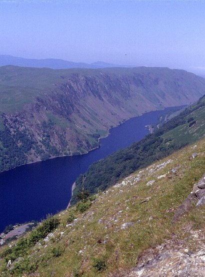
Situated in the southeastern part of the Argyll and Bute council area, An Cnap offers breathtaking panoramic views of the surrounding landscape. The hill is characterized by its distinctive conical shape and its steep slopes covered in heather and grasses, which provide a vibrant display of colors during the summer months.
The ascent of An Cnap is typically approached from the south, starting from the small village of Taynuilt. Hikers can follow a well-defined path that gradually ascends through open moorland, passing through rocky outcrops and crossing several small streams. As the climb progresses, the terrain becomes steeper, requiring more effort and concentration.
Reaching the summit of An Cnap rewards hikers with stunning vistas across Loch Etive and the surrounding mountain ranges. On clear days, it is possible to spot the peaks of Ben Cruachan and Ben Starav in the distance, adding to the allure of this picturesque location.
An Cnap is a popular destination for outdoor enthusiasts, attracting hikers, nature lovers, and photographers alike. Its accessibility and relatively moderate difficulty make it an ideal choice for those seeking a rewarding outdoor experience in the Scottish Highlands.
If you have any feedback on the listing, please let us know in the comments section below.
An Cnap Images
Images are sourced within 2km of 56.316667/-5.2364158 or Grid Reference NM9918. Thanks to Geograph Open Source API. All images are credited.


An Cnap is located at Grid Ref: NM9918 (Lat: 56.316667, Lng: -5.2364158)
Unitary Authority: Argyll and Bute
Police Authority: Argyll and West Dunbartonshire
What 3 Words
///parkland.nearing.data. Near Inveraray, Argyll & Bute
Nearby Locations
Related Wikis
Battle of Red Ford
The Battle of Red Ford or Battle of the String of Lorne was a battle in 1294 or else after September 1296 between Clan Campbell and Clan MacDougall in...

Loch Awe
Loch Awe (Scottish Gaelic: Loch Obha; also sometimes anglicised as Lochawe, Lochaw, or Lochow) is a large body of freshwater in Argyll and Bute, Scottish...

Beochlich
Beochlich (the Living Stone) is the name of a hydro electric project (taken from the burn of the same name) to the south-east of Loch Awe, and 9 km north...
Annat, Argyll
Annat (Scottish Gaelic: An Annaid) is a village at the head of Upper Loch Torridon in Argyll and Bute, Scotland. == References ==
Have you been to An Cnap?
Leave your review of An Cnap below (or comments, questions and feedback).