Cairnbowie Hill

Hill, Mountain in Wigtownshire

Scotland

Cairnbowie Hill

North Cairn Farm Kirkcolm The view of North Cairn farmhouse, over the hill behind are views of the Northern Ireland coastline.
North Cairn Farm Kirkcolm Credit: Bill Allen

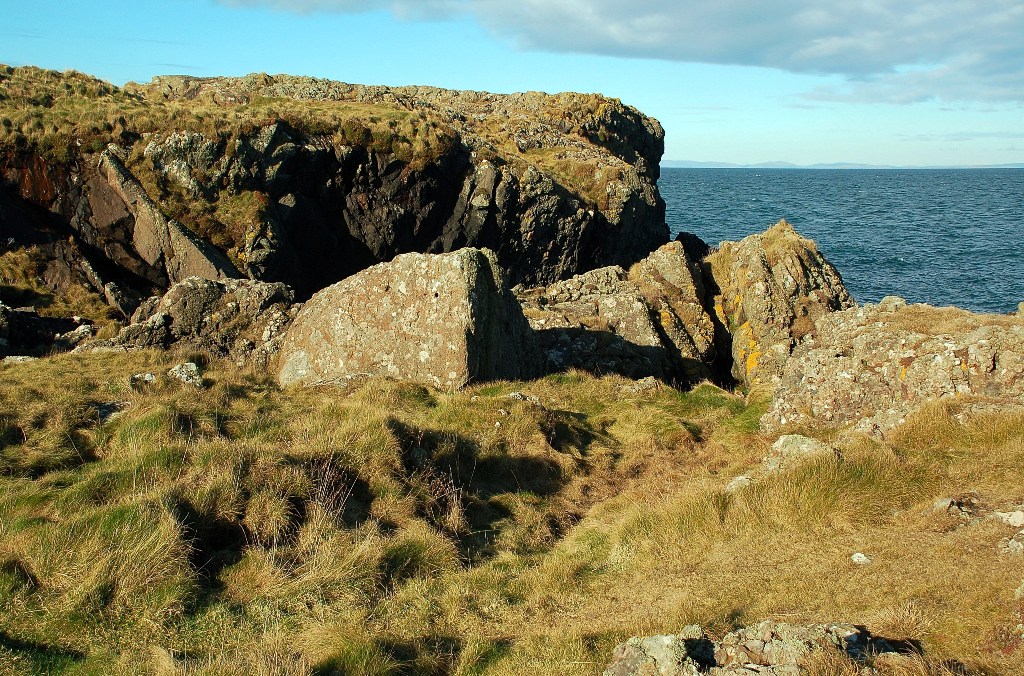
Cairnbowie Hill is a prominent hill located in Wigtownshire, Scotland. It stands at an elevation of approximately 350 meters (1,148 feet) above sea level, making it a notable feature in the area's landscape. The hill is situated near the town of Stranraer, providing a scenic backdrop to the surrounding countryside.

The summit of Cairnbowie Hill offers breathtaking views of Wigtownshire and the Irish Sea. On clear days, visitors can enjoy panoramic vistas that stretch across the rolling hills, farmland, and coastal areas. The hill is often frequented by hikers and nature enthusiasts who are drawn to its natural beauty and peaceful atmosphere.

Cairnbowie Hill is characterized by its distinctive shape, with a gently sloping ascent leading to a rounded peak. The terrain is mainly composed of grassy slopes and heather-covered moorland, which provides a habitat for a variety of flora and fauna. It is not uncommon to spot grazing sheep or other wildlife while exploring the area.

For those interested in history, Cairnbowie Hill is also home to several ancient remains. There are remnants of prehistoric settlements and burial sites scattered across the hill, offering a glimpse into the region's rich past.

Overall, Cairnbowie Hill is a picturesque and historically significant landmark in Wigtownshire. Its accessibility, stunning views, and historical significance make it a popular destination for both locals and visitors alike.

If you have any feedback on the listing, please let us know in the comments section below.

Cairnbowie Hill Images

Images are sourced within 2km of 54.985009/-5.1453211 or Grid Reference NW9870. Thanks to Geograph Open Source API. All images are credited.

North Cairn Farm Kirkcolm The view of North Cairn farmhouse, over the hill behind are views of the Northern Ireland coastline.
North Cairn Farm Kirkcolm
The view of North Cairn farmhouse, over the hill behind are views of the Northern Ireland coastline.
Damhouse Farm, The Rhins
Pigs and Arks Barnhills Farm.
Pigs and Arks
Barnhills Farm.
Knockneen Farm, The Rhins
Kirkbryde, The Rhins
Cairnside Farm, The Rhins Ireland on the horizon.
Cairnside Farm, The Rhins
Ireland on the horizon.
Cairnside Farm, The Rhins Kintyre on the horizon.
Cairnside Farm, The Rhins
Kintyre on the horizon.
North Cairn Farm, The Rhins
Remains of Corsewall Castle Picturesque 15th century ruin.
Remains of Corsewall Castle
Picturesque 15th century ruin.
Shoreline Grazing at Port Gavillan The cattle had access to the shoreline at the end of the farm track.  Some were grazing on the grass, but others were out among the Genoch Rocks.
Shoreline Grazing at Port Gavillan
The cattle had access to the shoreline at the end of the farm track. Some were grazing on the grass, but others were out among the Genoch Rocks.
Marshland View at Braid Port Looking across the marshland from the higher ground.  There are two types of marsh here - the area of reeds, and the salt-marsh behind it.
Marshland View at Braid Port
Looking across the marshland from the higher ground. There are two types of marsh here - the area of reeds, and the salt-marsh behind it.
Parking - Just For You A privately-provided parking and picnic space near the disused North Cairn Farm.
Parking - Just For You
A privately-provided parking and picnic space near the disused North Cairn Farm.
Shoreline View at Braid Port Looking towards Genoch Rocks, in the next square.  The Kintyre Peninsula is visible on the skyline.
Shoreline View at Braid Port
Looking towards Genoch Rocks, in the next square. The Kintyre Peninsula is visible on the skyline.
At Braid Port The rocky shoreline at Braid Port, viewed at low tide on a fine February afternoon.
At Braid Port
The rocky shoreline at Braid Port, viewed at low tide on a fine February afternoon.
North Cairn Chain Home Radar Station The shoreline here has a number of war-time buildings, belonging to a Chain Home radar site.  This building, which is now falling apart, may have been the receiver block.  The command bunker on the left, which is shown on the Landranger map, is still intact.
North Cairn Chain Home Radar Station
The shoreline here has a number of war-time buildings, belonging to a Chain Home radar site. This building, which is now falling apart, may have been the receiver block. The command bunker on the left, which is shown on the Landranger map, is still intact.
War-Time Radar Station at North Cairn The shoreline here has a number of war-time buildings, belonging to the North Cairn "Chain Home" radar station.  "Chain Home" was the code name for the ring of radar stations which protected Britain during the Second World War.  This photo shows one of the power houses, which is still largely intact.  To see the station at Saligo Bay, on Islay, see <a href="https://www.geograph.org.uk/photo/15341">NR2166 : Former WW2 Bunker</a>.
War-Time Radar Station at North Cairn
The shoreline here has a number of war-time buildings, belonging to the North Cairn "Chain Home" radar station. "Chain Home" was the code name for the ring of radar stations which protected Britain during the Second World War. This photo shows one of the power houses, which is still largely intact. To see the station at Saligo Bay, on Islay, see NR2166 : Former WW2 Bunker.
Modern Standing Stones? When I approached this area, I wondered if these were ancient standing stones. A closer look showed that they are concrete blocks, which formerly supported a radio tower with radar fixed on the top.  This site was part of the "Chain Home" network of radar stations which protected Britain during the Second World War.  To see a similar site in southern England, see <a href="https://www.geograph.org.uk/photo/307064">TQ9623 : Chain Home radar station, Rye</a>.
Modern Standing Stones?
When I approached this area, I wondered if these were ancient standing stones. A closer look showed that they are concrete blocks, which formerly supported a radio tower with radar fixed on the top. This site was part of the "Chain Home" network of radar stations which protected Britain during the Second World War. To see a similar site in southern England, see TQ9623 : Chain Home radar station, Rye.
Draining the Marsh The land immediately in from Braid Port is low-lying and marshy.  This fairly new ditch was allowing water to drain freely towards the sea.
Draining the Marsh
The land immediately in from Braid Port is low-lying and marshy. This fairly new ditch was allowing water to drain freely towards the sea.
Show me another place!

Cairnbowie Hill is located at Grid Ref: NW9870 (Lat: 54.985009, Lng: -5.1453211)

Unitary Authority: Dumfries and Galloway

Police Authority: Dumfries and Galloway

What 3 Words

///masterpiece.pace.immunity. Near Cairnryan, Dumfries & Galloway

Related Wikis

Ervie

Ervie is a small village in Dumfries and Galloway, Scotland, in the Rhins of Galloway, just outside Stranraer.

Corsewall Point

Corsewall Point, or Corsill Point, is a headland at the northern end of the Rhins of Galloway in Scotland. A lighthouse, Corsewall Lighthouse, was placed...

Kirkcolm

Kirkcolm (Scots: Kirkcoam) is a village and civil parish on the northern tip of the Rhinns of Galloway peninsula, south-west Scotland. It is in Dumfries...

RAF Wig Bay

Royal Air Force Wig Bay, or more simply RAF Wig Bay, is a former Royal Air Force station near Stranraer, Dumfries and Galloway, Scotland The following...

Nearby Amenities

Located within 500m of 54.985009,-5.1453211
Power: pole
Lat/Long: 54.9829301/-5.1395953
Power: pole
Lat/Long: 54.9826869/-5.1406413
Power: pole
Lat/Long: 54.9824499/-5.141682
Power: pole
Lat/Long: 54.9820928/-5.1432109
Power: pole
Lat/Long: 54.9817788/-5.1446539
Power: pole
Lat/Long: 54.9814402/-5.1461667
Power: pole
Lat/Long: 54.9811601/-5.1473898
Power: pole
Lat/Long: 54.987378/-5.1415316
Power: pole
Lat/Long: 54.9870117/-5.1424448
Power: pole
Lat/Long: 54.9865618/-5.1435623
Power: pole
Lat/Long: 54.9861307/-5.1446563
Power: pole
Lat/Long: 54.9856808/-5.1458043
Power: pole
Lat/Long: 54.9853279/-5.1466611
Power: pole
Lat/Long: 54.984055/-5.1386511
Power: pole
Lat/Long: 54.9847716/-5.1392685
Power: pole
Lat/Long: 54.9855273/-5.139954
Power: pole
Lat/Long: 54.9861105/-5.1404306
Power: pole
Lat/Long: 54.9867544/-5.1409799
Power: pole
Lat/Long: 54.987735/-5.1418767
Power: pole
Lat/Long: 54.9881014/-5.141487
Power: pole
Lat/Long: 54.9884475/-5.1411865
Power: pole
Lat/Long: 54.9888139/-5.1411795
Power: pole
Lat/Long: 54.9820559/-5.1411302
Power: pole
Lat/Long: 54.9815951/-5.1404188
The data included in this document is from www.openstreetmap.org. The data is made available under ODbL.

Have you been to Cairnbowie Hill?

Leave your review of Cairnbowie Hill below (or comments, questions and feedback).