Cairn Hill

Hill, Mountain in Wigtownshire

Scotland

Cairn Hill

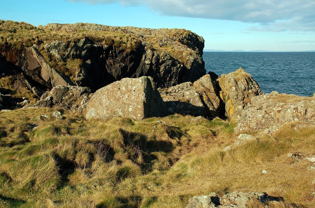
Craig Laggan or the Ebbstone An emergent rock, the remains of a sea stack, 1.85 km away from the viewpoint.
Craig Laggan or the Ebbstone Credit: M J Richardson

Cairn Hill is a prominent hill located in Wigtownshire, a historic county in southwestern Scotland. Standing at an elevation of 662 meters (2,172 feet), it is one of the highest points in the area and offers breathtaking views of the surrounding countryside.

Situated in the Galloway Hills, Cairn Hill is part of a range of hills that form the backbone of the region. Its distinctive shape, characterized by a rounded summit and steep slopes, is a result of glacial activity during the last ice age. The hill is predominantly composed of granite, which gives it a rugged and weathered appearance.

Cairn Hill is a popular destination for outdoor enthusiasts, attracting hikers and mountain climbers from near and far. Several well-marked trails provide access to the summit, offering a variety of difficulty levels to cater to different skill levels. Along the way, visitors can appreciate the diverse flora and fauna that thrive in the hill's varied habitats.

The area surrounding Cairn Hill is also rich in history and heritage. The nearby village of Wigtown, known as Scotland's National Book Town, is home to numerous bookshops and hosts an annual book festival. Additionally, the hill is in close proximity to the Galloway Forest Park, a designated Dark Sky Park renowned for its stargazing opportunities.

Whether you are seeking a challenging hike, stunning vistas, or a glimpse into Scotland's cultural heritage, a visit to Cairn Hill in Wigtownshire is sure to leave a lasting impression.

If you have any feedback on the listing, please let us know in the comments section below.

Cairn Hill Images

Images are sourced within 2km of 54.98278/-5.1684564 or Grid Reference NW9769. Thanks to Geograph Open Source API. All images are credited.

Craig Laggan or the Ebbstone An emergent rock, the remains of a sea stack, 1.85 km away from the viewpoint.
Craig Laggan or the Ebbstone
An emergent rock, the remains of a sea stack, 1.85 km away from the viewpoint.
North Cairn Farm Kirkcolm The view of North Cairn farmhouse, over the hill behind are views of the Northern Ireland coastline.
North Cairn Farm Kirkcolm
The view of North Cairn farmhouse, over the hill behind are views of the Northern Ireland coastline.
Knockneen Farm, The Rhins
Cairnside Farm, The Rhins Ireland on the horizon.
Cairnside Farm, The Rhins
Ireland on the horizon.
Cairnside Farm, The Rhins Kintyre on the horizon.
Cairnside Farm, The Rhins
Kintyre on the horizon.
North Cairn Farm, The Rhins
Shoreline Grazing at Port Gavillan The cattle had access to the shoreline at the end of the farm track.  Some were grazing on the grass, but others were out among the Genoch Rocks.
Shoreline Grazing at Port Gavillan
The cattle had access to the shoreline at the end of the farm track. Some were grazing on the grass, but others were out among the Genoch Rocks.
Marshland View at Braid Port Looking across the marshland from the higher ground.  There are two types of marsh here - the area of reeds, and the salt-marsh behind it.
Marshland View at Braid Port
Looking across the marshland from the higher ground. There are two types of marsh here - the area of reeds, and the salt-marsh behind it.
Genoch Rocks Looking out across the rocks at low tide.  The concrete steps in the foreground have come from nearby old war-time buildings.
Genoch Rocks
Looking out across the rocks at low tide. The concrete steps in the foreground have come from nearby old war-time buildings.
Genoch Rocks at Low Tide Viewed on a fine February afternoon with the tide well out. Cattle were grazing on the shoreline grass, with some seen out on the rocks.
Genoch Rocks at Low Tide
Viewed on a fine February afternoon with the tide well out. Cattle were grazing on the shoreline grass, with some seen out on the rocks.
On Genoch Rocks Genoch rocks at low tide on a fine February afternoon.  Far-off Ailsa Craig is visible on the skyline, on the right.
On Genoch Rocks
Genoch rocks at low tide on a fine February afternoon. Far-off Ailsa Craig is visible on the skyline, on the right.
Parking - Just For You A privately-provided parking and picnic space near the disused North Cairn Farm.
Parking - Just For You
A privately-provided parking and picnic space near the disused North Cairn Farm.
Shoreline View at Braid Port Looking towards Genoch Rocks, in the next square.  The Kintyre Peninsula is visible on the skyline.
Shoreline View at Braid Port
Looking towards Genoch Rocks, in the next square. The Kintyre Peninsula is visible on the skyline.
At Braid Port The rocky shoreline at Braid Port, viewed at low tide on a fine February afternoon.
At Braid Port
The rocky shoreline at Braid Port, viewed at low tide on a fine February afternoon.
North Cairn Chain Home Radar Station The shoreline here has a number of war-time buildings, belonging to a Chain Home radar site.  This building, which is now falling apart, may have been the receiver block.  The command bunker on the left, which is shown on the Landranger map, is still intact.
North Cairn Chain Home Radar Station
The shoreline here has a number of war-time buildings, belonging to a Chain Home radar site. This building, which is now falling apart, may have been the receiver block. The command bunker on the left, which is shown on the Landranger map, is still intact.
War-Time Radar Station at North Cairn The shoreline here has a number of war-time buildings, belonging to the North Cairn "Chain Home" radar station.  "Chain Home" was the code name for the ring of radar stations which protected Britain during the Second World War.  This photo shows one of the power houses, which is still largely intact.  To see the station at Saligo Bay, on Islay, see <a href="https://www.geograph.org.uk/photo/15341">NR2166 : Former WW2 Bunker</a>.
War-Time Radar Station at North Cairn
The shoreline here has a number of war-time buildings, belonging to the North Cairn "Chain Home" radar station. "Chain Home" was the code name for the ring of radar stations which protected Britain during the Second World War. This photo shows one of the power houses, which is still largely intact. To see the station at Saligo Bay, on Islay, see NR2166 : Former WW2 Bunker.
Modern Standing Stones? When I approached this area, I wondered if these were ancient standing stones. A closer look showed that they are concrete blocks, which formerly supported a radio tower with radar fixed on the top.  This site was part of the "Chain Home" network of radar stations which protected Britain during the Second World War.  To see a similar site in southern England, see <a href="https://www.geograph.org.uk/photo/307064">TQ9623 : Chain Home radar station, Rye</a>.
Modern Standing Stones?
When I approached this area, I wondered if these were ancient standing stones. A closer look showed that they are concrete blocks, which formerly supported a radio tower with radar fixed on the top. This site was part of the "Chain Home" network of radar stations which protected Britain during the Second World War. To see a similar site in southern England, see TQ9623 : Chain Home radar station, Rye.
Shore View at Braid Port Looking towards Oust Rocks from the rocky shore at Braid Port on a fine February afternoon.  Arran and Ailsa Craig are visible on the skyline.
Shore View at Braid Port
Looking towards Oust Rocks from the rocky shore at Braid Port on a fine February afternoon. Arran and Ailsa Craig are visible on the skyline.
Show me another place!

Cairn Hill is located at Grid Ref: NW9769 (Lat: 54.98278, Lng: -5.1684564)

Unitary Authority: Dumfries and Galloway

Police Authority: Dumfries and Galloway

What 3 Words

///enough.downhill.abacus. Near Cairnryan, Dumfries & Galloway

Nearby Locations

Cairn Hill

Related Wikis

Corsewall Point

Corsewall Point, or Corsill Point, is a headland on the northwest coast of Wigtownshire, Kirkcolm near Stranraer, Dumfries and Galloway, Scotland. A lighthouse...

Ervie

Ervie is a small village in Dumfries and Galloway, Scotland, in the Rhins of Galloway, just outside Stranraer.

Kirkcolm

Kirkcolm (Scots: Kirkcoam) is a village and civil parish on the northern tip of the Rhinns of Galloway peninsula, south-west Scotland. It is in Dumfries...

RAF Wig Bay

Royal Air Force Wig Bay, or more simply RAF Wig Bay, is a former Royal Air Force station near Stranraer, Dumfries and Galloway, Scotland The following...

Galdenoch Castle

Galdenoch Castle is a tower house near the Scottish village of Leswalt in the Council Area Dumfries and Galloway . The ruin is listed as a Scheduled Monument...

Leswalt

Leswalt (Scottish Gaelic: Lios Uillt) is a village and civil parish in Dumfries and Galloway, south-west Scotland. It lies between Portpatrick and Stranraer...

Loch Ryan

Loch Ryan (Scottish Gaelic: Loch Rìoghaine, pronounced [l̪ˠɔx ˈrˠiː.ɛɲə]) is a Scottish sea loch that acts as an important natural harbour for shipping...

Cairnryan Harbour

Cairnryan Harbour is a roll-on ferry terminal on Loch Ryan in south west Scotland north of Stranraer. In World War II it was developed as an emergency...

Nearby Amenities

Located within 500m of 54.98278,-5.1684564
Place: farm
Lat/Long: 54.9856348/-5.1646473
Place: farm
Lat/Long: 54.9790473/-5.1711704
Power: pole
Lat/Long: 54.979412/-5.1698157
Power: pole
Lat/Long: 54.9788529/-5.1684588
Power: pole
Lat/Long: 54.979408/-5.1699824
Power: pole
Lat/Long: 54.9795077/-5.169325
Power: pole
Lat/Long: 54.9796747/-5.1685409
Power: pole
Lat/Long: 54.9798/-5.1679188
Power: pole
Lat/Long: 54.9799347/-5.1672333
Power: pole
Lat/Long: 54.9800681/-5.1666229
Power: pole
Lat/Long: 54.9802109/-5.1659374
Power: pole
Lat/Long: 54.9802998/-5.1652754
The data included in this document is from www.openstreetmap.org. The data is made available under ODbL.

Have you been to Cairn Hill?

Leave your review of Cairn Hill below (or comments, questions and feedback).